TopoQuest Logo
Do you find TopoQuest useful?
Help keep TopoQuest running and adding new maps/features by donating!
Bitcoin:  19c7KJd3qBynnjoSw5npx9KScwjBe4ifkT
Litecoin:  LXs6TkuXGGXo1vDsWCkWVdjQX94eUKd6ui
Home View Maps Find Maps Find Places Resources & Links


Winston-Salem East, North Carolina Topographic Map

USGS Map Title: Winston-Salem East, NC
USGS Map MRC: 36080A2
DRG (GeoTIFF) Download: o36080a2.tif


Neighboring USGS Topographic Map Quads:


  Rural Hall, NC  
36080B3
 

  Walkertown, NC  
36080B2
 

  Belews Creek, NC  
36080B1
 

  Winston-Salem West, NC  
36080A3
 

  Winston-Salem East, NC  
36080A2
 

  Kernersville, NC  
36080A1
 

  Welcome, NC  
35080H3
 

  Midway, NC  
35080H2
 

  High Point West, NC  
35080H1


Map MRC Location:

N37°
W81°
N37°
W80°
H8 H7 H6 H5 H4 H3 H2 H1
G8 G7 G6 G5 G4 G3 G2 G1
F8 F7 F6 F5 F4 F3 F2 F1
E8 E7 E6 E5 E4 E3 E2 E1
D8 D7 D6 D5 D4 D3 D2 D1
C8 C7 C6 C5 C4 C3 C2 C1
B8 B7 B6 B5 B4 B3 B2 B1
A8 A7 A6 A5 A4 A3 A2 A1
N36°
W81°
N36°
W80°

Winston-Salem East, NC USGS 1:24K Topographic Map Preview:
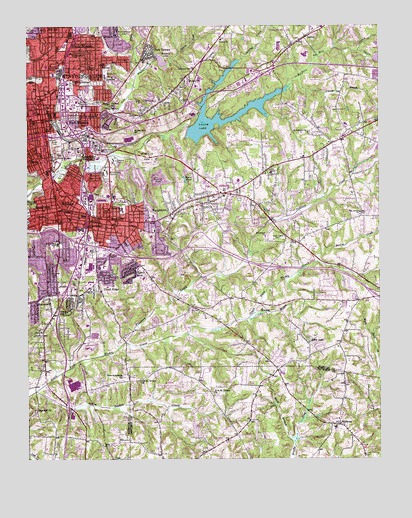
Winston-Salem East, NC USGS Topographic Map
Click on map above to begin viewing in our Map Viewer.

This topographic map contains these locations and features:
Feature Name Type Latitude Longitude GNIS ID View Map
ArcadiaPopulated PlaceN36.0710°W80.2459°1018840View Map
Ashley SchoolSchoolN36.1179°W80.2137°1007056View Map
Atkins High SchoolSchoolN36.1101°W80.2223°980350View Map
Bellevue CemeteryCemeteryN36.0618°W80.2295°980957View Map
Benton Convention CenterBuildingN36.0999°W80.2473°1984481View Map
Blevins Airport (historical)AirportN36.0982°W80.1456°998029View Map
Blum ParkParkN36.1207°W80.2381°1007382View Map
Bowman-Gray StadiumParkN36.0826°W80.2223°981775View Map
Boys SchoolSchoolN36.0899°W80.2342°1007050View Map
Brushy ForkStreamN36.0874°W80.2212°982066View Map
Brushy Fork BranchStreamN36.1179°W80.1962°982067View Map
Brushy Fork SchoolSchoolN36.0949°W80.2120°982069View Map
Buck BranchStreamN36.0046°W80.1553°982096View Map
Center City Post OfficePost OfficeN36.0962°W80.2461°2766603View Map
Central ParkParkN36.0832°W80.2398°982965View Map
Central Park PoolParkN36.0837°W80.2362°1007044View Map
Charleston (historical)LocaleN36.0590°W80.2114°1007034View Map
CityviewPopulated PlaceN36.1018°W80.2048°1019679View Map
Cityview SchoolSchoolN36.1132°W80.1912°983203View Map
Civitan ParkParkN36.0846°W80.2270°1007043View Map
Columbia HeightsPopulated PlaceN36.0904°W80.2275°983402View Map
Crews ChurchChurchN36.1212°W80.1809°983743View Map
Dreamland Park SchoolSchoolN36.1168°W80.2128°984329View Map
East Forsyth High SchoolSchoolN36.1168°W80.1506°1007041View Map
East WinstonPopulated PlaceN36.1004°W80.2289°1020095View Map
East Winston CenterLocaleN36.1012°W80.2314°1007383View Map
Eastok SchoolSchoolN36.0557°W80.2248°1007037View Map
Easton ViewPopulated PlaceN36.0562°W80.2098°984564View Map
Evergreen CemeteryCemeteryN36.1051°W80.2162°984878View Map
Fairview SchoolSchoolN36.1174°W80.2345°984934View Map
Fiddlers CreekStreamN36.0337°W80.2150°985061View Map
Fishers BranchStreamN36.1101°W80.1545°985108View Map
Forest ParkParkN36.0732°W80.2162°985287View Map
Forest Park Elementary SchoolSchoolN36.0718°W80.2153°1024824View Map
Forsyth County CourthouseBuildingN36.0982°W80.2442°1003848View Map
Forsyth County Emergency Medical ServicesBuildingN36.1010°W80.2351°2720548View Map
Forsyth County Sheriff's OfficeBuildingN36.0983°W80.2426°2769727View Map
Forsyth Vocational High SchoolSchoolN36.0621°W80.2389°1024860View Map
Four SeasonsPopulated PlaceN36.0565°W80.1553°1005534View Map
Fourteenth Street ParkParkN36.1121°W80.2198°985344View Map
Fourteenth Street SchoolSchoolN36.1124°W80.2223°985345View Map
Frazier CreekStreamN36.1112°W80.2106°985374View Map
Friedland ChurchChurchN36.0646°W80.1653°985412View Map
Glen High EstatesPopulated PlaceN36.0821°W80.1442°1005413View Map
Gray High SchoolSchoolN36.0743°W80.2375°985988View Map
GuthriePopulated PlaceN36.1215°W80.1512°986269View Map
Happy Hill ParkParkN36.0818°W80.2373°986377View Map
Hartman BranchStreamN36.0007°W80.2473°986471View Map
Hill SchoolSchoolN36.0662°W80.2048°1007039View Map
Hines LakeLakeN36.0347°W80.1499°986844View Map
Hiram H Ward Federal BuildingBuildingN36.0971°W80.2431°1848185View Map
Holly AcresPopulated PlaceN36.0037°W80.1789°1002060View Map
Hopewell ChurchChurchN36.0149°W80.2470°987056View Map
John Vogler HouseBuildingN36.0899°W80.2342°1007048View Map
Kerners Mill CreekStreamN36.0968°W80.1848°987931View Map
Konnoak Elementary SchoolSchoolN36.0510°W80.2470°1007035View Map
Lower Angel LakeReservoirN36.1168°W80.1281°1000110View Map
Lower Angel Lake DamDamN36.1168°W80.1281°1000111View Map
Lowery Mill CreekStreamN36.0990°W80.1881°989105View Map
Martin Mill CreekStreamN36.1246°W80.1645°989403View Map
Merriweather EstatesPopulated PlaceN36.0296°W80.1603°1005408View Map
Miksch Tobacco ShopBuildingN36.0899°W80.2342°1007055View Map
Morningside ManorPopulated PlaceN36.0771°W80.2031°1005412View Map
Mount Zion ChurchChurchN36.1096°W80.1920°990668View Map
Museum of Early Southern Decorative ArtsBuildingN36.0899°W80.2342°1007046View Map
Myers PondReservoirN36.0815°W80.1948°990823View Map
New Friendship Baptist ChurchChurchN36.0240°W80.2150°990967View Map
New Mount Vernon Methodist ChurchChurchN36.0193°W80.1845°991074View Map
Nichols LakeReservoirN36.0883°W80.1589°1000049View Map
Nichols Lake DamDamN36.0885°W80.1581°1000050View Map
North SchoolSchoolN36.1135°W80.2425°991271View Map
North WinstonPopulated PlaceN36.1199°W80.2339°991282View Map
Oak Grove ChurchChurchN36.0712°W80.1317°991391View Map
Oak Lawn ChurchChurchN36.0826°W80.1639°991424View Map
Oaklawn Memorial GardensCemeteryN36.0732°W80.1734°1007057View Map
Old Mount Vernon ChurchChurchN36.0226°W80.2100°991588View Map
Old SalemLocaleN36.0899°W80.2342°1007045View Map
Park TerracePopulated PlaceN36.1179°W80.2084°1021805View Map
Parkview Shopping CenterLocaleN36.0787°W80.1812°1007040View Map
Philo Middle SchoolSchoolN36.0537°W80.2484°1007036View Map
Piedmont Memorial GardensCemeteryN36.0524°W80.1414°1007381View Map
Piedmont QuarryBasinN36.0812°W80.2048°992168View Map
Reynolds Memorial HospitalHospitalN36.1029°W80.2317°1024257View Map
Reynolds ParkParkN36.0876°W80.2075°993259View Map
Rolling AcresPopulated PlaceN36.0082°W80.1839°1002101View Map
RosemontPopulated PlaceN36.0479°W80.2425°993709View Map
Saint Delight ChurchChurchN36.0943°W80.1500°993882View Map
SalemPopulated PlaceN36.0837°W80.2464°1022467View Map
Salem CemeteryCemeteryN36.0915°W80.2389°994158View Map
Salem CollegeSchoolN36.0876°W80.2403°994181View Map
Salem LakeReservoirN36.0984°W80.1763°1000064View Map
Salem Lake DamDamN36.0951°W80.1914°1000065View Map
Salem TavernBuildingN36.0904°W80.2342°1007047View Map
Samaritan Baptist ChurchChurchN36.0257°W80.1500°1956191View Map
Sawmill BranchStreamN36.0415°W80.1703°994393View Map
Sedge GardenPopulated PlaceN36.0887°W80.1389°1867439View Map
Sedge Garden SchoolSchoolN36.0957°W80.1356°994479View Map
ShalimarPopulated PlaceN36.0912°W80.1970°1005416View Map
Shultz Shoemaker ShopBuildingN36.0899°W80.2342°1007054View Map
Single Brothers HouseBuildingN36.0899°W80.2342°1007052View Map
Skyland ParkParkN36.1007°W80.2192°994892View Map
Skyland SchoolSchoolN36.1015°W80.2192°994893View Map
Skyview ParkPopulated PlaceN36.1012°W80.2103°1005417View Map
Smith CreekStreamN36.1174°W80.1323°994970View Map
Soakas CreekStreamN36.0199°W80.2467°995083View Map
South SidePopulated PlaceN36.0721°W80.2395°1022716View Map
South Winston StationLocaleN36.0674°W80.2284°995224View Map
Sprague Street ParkParkN36.0654°W80.2087°1007038View Map
SunnysidePopulated PlaceN36.0693°W80.2206°1022845View Map
Swaim CreekStreamN36.0571°W80.1473°995734View Map
Tar BranchStreamN36.0804°W80.2414°995847View Map
Township of BroadbayCivilN36.0307°W80.1912°1026675View Map
Union RidgePopulated PlaceN36.0518°W80.2250°1023044View Map
Vierling HouseBuildingN36.0899°W80.2342°1007053View Map
WallburgPopulated PlaceN36.0101°W80.1392°996726View Map
Wallburg Elementary SchoolSchoolN36.0104°W80.1431°1002120View Map
Wallburg Fire DepartmentBuildingN36.0075°W80.1341°2638575View Map
Wallburg Post OfficePost OfficeN36.0099°W80.1378°2774377View Map
Wallburg SchoolSchoolN36.0093°W80.1420°1007033View Map
Washington CemeteryCemeteryN36.0190°W80.1998°1007122View Map
Washington ParkParkN36.0735°W80.2481°996827View Map
WaughtownPopulated PlaceN36.0696°W80.2039°1023133View Map
Waughtown Post OfficePost OfficeN36.0699°W80.2064°2774119View Map
WBFJ-AM (Winston-Salem)TowerN36.1093°W80.2462°1018542View Map
WillowbendPopulated PlaceN36.1118°W80.1375°1005415View Map
Winkler BakeryBuildingN36.0899°W80.2342°1007051View Map
Winston - Salem Fire Department AB Bullard Fire Station 1BuildingN36.1021°W80.2485°2639628View Map
Winston - Salem Fire Department Lester E Ervin Fire Station 4BuildingN36.0947°W80.2282°1007049View Map
Winston - Salem Fire Department Palmer Lane South Fire Station 5BuildingN36.0496°W80.2293°2639627View Map
Winston - Salem Fire Department Parkview Fire Station 11BuildingN36.0762°W80.1857°2639620View Map
Winston - Salem Fire Department Station 17BuildingN36.1133°W80.1723°2639545View Map
Winston - Salem Police DepartmentBuildingN36.1041°W80.2482°2769695View Map
Winston LakeReservoirN36.1149°W80.2019°1000104View Map
Winston Lake DamDamN36.1151°W80.2031°1000105View Map
Winston Lake Golf CourseLocaleN36.1221°W80.1995°1002306View Map
Winston Salem Post OfficePost OfficeN36.1134°W80.2429°1024963View Map
Winston-SalemPopulated PlaceN36.0999°W80.2442°997498View Map
Winston-Salem Air Force Station (historical)MilitaryN36.0444°W80.1369°2090230View Map
Winston-Salem City HallBuildingN36.0951°W80.2428°1003847View Map
Winston-Salem State UniversitySchoolN36.0918°W80.2262°997499View Map
WoodbridgePopulated PlaceN36.0960°W80.1650°1005414View Map
Woodland SchoolSchoolN36.1087°W80.2328°997592View Map
WSMX-AM (Winston-Salem)TowerN36.1096°W80.2114°1018543View Map
WSNC-FM (Winston-Salem)TowerN36.0935°W80.2312°1018332View Map

Note: Coordinates in the location and feature list above are referenced to NAD83 datum.


Copyright (C) 2008-2024 Ryan Niemi / Sunset Dynamics ... All Rights Reserved