TopoQuest Logo
Do you find TopoQuest useful?
Help keep TopoQuest running and adding new maps/features by donating!
Bitcoin:  19c7KJd3qBynnjoSw5npx9KScwjBe4ifkT
Litecoin:  LXs6TkuXGGXo1vDsWCkWVdjQX94eUKd6ui
Home View Maps Find Maps Find Places Resources & Links


Worden, Oregon Topographic Map

USGS Map Title: Worden, OR
USGS Map MRC: 42121A7
DRG (GeoTIFF) Download: o42121a7.tif


Neighboring USGS Topographic Map Quads:


  Keno, OR  
42121B8
 

  Klamath Falls, OR  
42121B7
 

  Altamont, OR  
42121B6
 

  Hamaker Mountain, OR  
42121A8
 

  Worden, OR  
42121A7
 

  Lost River, OR  
42121A6
 

  Dorris, CA  
41121H8
 

  Sheepy Lake, CA  
41121H7
 

  Lower Klamath Lake, CA  
41121H6


Map MRC Location:

N43°
W122°
N43°
W121°
H8 H7 H6 H5 H4 H3 H2 H1
G8 G7 G6 G5 G4 G3 G2 G1
F8 F7 F6 F5 F4 F3 F2 F1
E8 E7 E6 E5 E4 E3 E2 E1
D8 D7 D6 D5 D4 D3 D2 D1
C8 C7 C6 C5 C4 C3 C2 C1
B8 B7 B6 B5 B4 B3 B2 B1
A8 A7 A6 A5 A4 A3 A2 A1
N42°
W122°
N42°
W121°

Worden, OR USGS 1:24K Topographic Map Preview:
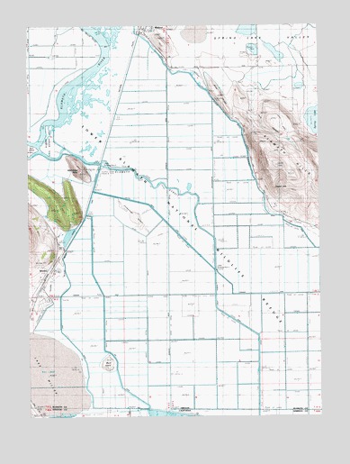
Worden, OR USGS Topographic Map
Click on map above to begin viewing in our Map Viewer.

This topographic map contains these locations and features:
Feature Name Type Latitude Longitude GNIS ID View Map
Ady (historical)LocaleN42.0790°W121.8456°1132509View Map
Ady CanalCanalN42.0329°W121.8436°1161246View Map
Big Hot SpringSpringN42.1151°W121.7872°1133074View Map
Captain JackSummitN42.0729°W121.7703°1136121View Map
Center CanalCanalN42.0549°W121.8075°1161308View Map
Furber MarshSwampN42.0902°W121.8543°1132510View Map
Gray RidgeRidgeN42.1021°W121.7931°1121348View Map
Holland (historical)LocaleN42.0790°W121.8456°1132508View Map
Jory CanyonValleyN42.1029°W121.7800°1122537View Map
Keno Rural Fire Protection District Station 2BuildingN42.0454°W121.8674°2576675View Map
Klamath Hills TrailheadLocaleN42.0608°W121.7542°2548756View Map
Klamath StraitCanalN42.0785°W121.8303°1161407View Map
Klamath Strait DrainCanalN42.0324°W121.7903°226642View Map
Lake MillerLakeN42.0112°W121.8693°234305View Map
North CanalCanalN42.0610°W121.7628°1124725View Map
Skull IslandSummitN42.0168°W121.8422°1161517View Map
Tulana FarmsLocaleN42.0379°W121.8675°1128281View Map
United States Bureau of Reclamation Pumping Plant ELocaleN42.0474°W121.7958°1163785View Map
United States Bureau of Reclamation Pumping Plant FLocaleN42.0782°W121.8447°1163786View Map
West CanalCanalN42.0235°W121.8567°1162439View Map
Wild Horse ButteSummitN42.0785°W121.8522°1129048View Map
WordenPopulated PlaceN42.0454°W121.8664°1136925View Map
Worden CemeteryCemeteryN42.0457°W121.8694°1132507View Map
Worden Post Office (historical)Post OfficeN42.0454°W121.8664°1166212View Map
Zuckerman IslandSummitN42.0640°W121.8303°1161606View Map

Note: Coordinates in the location and feature list above are referenced to NAD83 datum.


Copyright (C) 2008-2025 Ryan Niemi / Sunset Dynamics ... All Rights Reserved