TopoQuest Logo
Do you find TopoQuest useful?
Help keep TopoQuest running and adding new maps/features by donating!
Bitcoin:  19c7KJd3qBynnjoSw5npx9KScwjBe4ifkT
Litecoin:  LXs6TkuXGGXo1vDsWCkWVdjQX94eUKd6ui
Home View Maps Find Maps Find Places Resources & Links


Workman Creek, Colorado Topographic Map

USGS Map Title: Workman Creek, CO
USGS Map MRC: 37107F1
DRG (GeoTIFF) Download: o37107f1.tif


Neighboring USGS Topographic Map Quads:


  Hermit Lakes, CO  
37107G2
 

  Bristol Head, CO  
37107G1
 

  Creede, CO  
37106G8
 

  Little Squaw Creek, CO  
37107F2
 

  Workman Creek, CO  
37107F1
 

  Spar City, CO  
37106F8
 

  Cimarrona Peak, CO  
37107E2
 

  Palomino Mountain, CO  
37107E1
 

  South River Peak, CO  
37106E8


Map MRC Location:

N38°
W108°
N38°
W107°
H8 H7 H6 H5 H4 H3 H2 H1
G8 G7 G6 G5 G4 G3 G2 G1
F8 F7 F6 F5 F4 F3 F2 F1
E8 E7 E6 E5 E4 E3 E2 E1
D8 D7 D6 D5 D4 D3 D2 D1
C8 C7 C6 C5 C4 C3 C2 C1
B8 B7 B6 B5 B4 B3 B2 B1
A8 A7 A6 A5 A4 A3 A2 A1
N37°
W108°
N37°
W107°

Workman Creek, CO USGS 1:24K Topographic Map Preview:
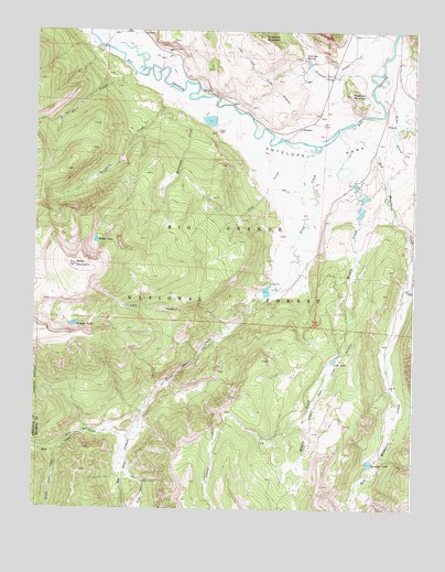
Workman Creek, CO USGS Topographic Map
Click on map above to begin viewing in our Map Viewer.

This topographic map contains these locations and features:
Feature Name Type Latitude Longitude GNIS ID View Map
Antelope MountainSummitN37.7486°W107.0503°187901View Map
Antelope ParkFlatN37.7114°W107.0359°187906View Map
Antelope SpringSpringN37.7433°W107.0375°187903View Map
Baldy LakeLakeN37.6951°W107.1050°187909View Map
Baldy MountainSummitN37.6886°W107.1117°187910View Map
Birdsie Warm SpringSpringN37.7281°W107.0545°1794690View Map
Cliff CreekStreamN37.7192°W107.0337°187913View Map
Copper CreekStreamN37.6581°W107.0803°187920View Map
Earl Mullens DamDamN37.7100°W107.0689°200602View Map
East Trout CreekStreamN37.6447°W107.0912°187919View Map
Fern CreekStreamN37.7386°W107.0928°187883View Map
Fern Greek TrailheadLocaleN37.7361°W107.1003°197049View Map
Hogback MountainSummitN37.7336°W107.0217°187904View Map
Ivy CreekStreamN37.6828°W107.0025°187915View Map
Jumper CreekStreamN37.6719°W107.0600°187912View Map
Jumper Creek DamDamN37.6733°W107.1139°199940View Map
Jumper Creek ReservoirReservoirN37.6732°W107.1120°199941View Map
Jumper LakeLakeN37.6731°W107.1120°187911View Map
Lime CreekStreamN37.7322°W107.0134°187905View Map
Love LakeReservoirN37.6640°W107.0263°187921View Map
Meadow Lake DamDamN37.7150°W107.0256°199630View Map
Meadow Lake ReservoirReservoirN37.7136°W107.0240°199631View Map
Middle CreekStreamN37.7081°W107.0095°187914View Map
Middle Creek Stock DrivewayTrailN37.6700°W107.0195°187916View Map
Middle Trout CreekStreamN37.6397°W107.1178°187917View Map
Red Mountain CreekStreamN37.7247°W107.0239°187907View Map
Rhodas ArchArchN37.6592°W107.0008°2677660View Map
Sowards Number 4 DamDamN37.7083°W107.0206°199640View Map
Sowards Reservoir Number 4ReservoirN37.7092°W107.0197°199641View Map
Streams LakeLakeN37.6373°W107.0142°187922View Map
Sulphur TunnelMineN37.6322°W107.0892°187918View Map
Trout CreekStreamN37.7247°W107.0248°187908View Map
West Trout CreekStreamN37.6447°W107.0912°187896View Map
Williams Creek LakeReservoirN37.7100°W107.0689°200603View Map
Woodfern CreekStreamN37.7353°W107.0812°187900View Map
Workman CreekStreamN37.7319°W107.0750°187902View Map

Note: Coordinates in the location and feature list above are referenced to NAD83 datum.


Copyright (C) 2008-2025 Ryan Niemi / Sunset Dynamics ... All Rights Reserved