TopoQuest Logo
Do you find TopoQuest useful?
Help keep TopoQuest running and adding new maps/features by donating!
Bitcoin:  19c7KJd3qBynnjoSw5npx9KScwjBe4ifkT
Litecoin:  LXs6TkuXGGXo1vDsWCkWVdjQX94eUKd6ui
Home View Maps Find Maps Find Places Resources & Links


Worley, Idaho Topographic Map

USGS Map Title: Worley, ID
USGS Map MRC: 47116D8
DRG (GeoTIFF) Download: o47116d8.tif


Neighboring USGS Topographic Map Quads:


  Mica Peak, WA  
47117E1
 

  Rockford Bay, ID  
47116E8
 

  Mica Bay, ID  
47116E7
 

  Setters, ID  
47117D1
 

  Worley, ID  
47116D8
 

  Harrison, ID  
47116D7
 

  Tekoa Mountain, WA  
47117C1
 

  Plummer, ID  
47116C8
 

  Chatcolet, ID  
47116C7


Map MRC Location:

N48°
W117°
N48°
W116°
H8 H7 H6 H5 H4 H3 H2 H1
G8 G7 G6 G5 G4 G3 G2 G1
F8 F7 F6 F5 F4 F3 F2 F1
E8 E7 E6 E5 E4 E3 E2 E1
D8 D7 D6 D5 D4 D3 D2 D1
C8 C7 C6 C5 C4 C3 C2 C1
B8 B7 B6 B5 B4 B3 B2 B1
A8 A7 A6 A5 A4 A3 A2 A1
N47°
W117°
N47°
W116°

Worley, ID USGS 1:24K Topographic Map Preview:
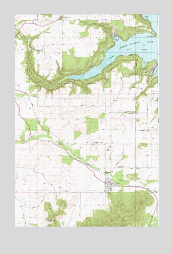
Worley, ID USGS Topographic Map
Click on map above to begin viewing in our Map Viewer.

This topographic map contains these locations and features:
Feature Name Type Latitude Longitude GNIS ID View Map
16 to 1 BayBayN47.4718°W116.8877°376017View Map
Alexander McDowell Rest AreaLocaleN47.4980°W116.9599°395047View Map
AmwacoLocaleN47.4763°W116.8988°395051View Map
Camp Four EchoesLocaleN47.4691°W116.9327°396509View Map
Cave BayBayN47.4674°W116.8757°383012View Map
City of WorleyCivilN47.4005°W116.9193°2412309View Map
Coeur d'Alene Indian CemeteryCemeteryN47.4101°W116.9110°395230View Map
Lake CreekStreamN47.4643°W116.9410°373446View Map
Lakeside Middle SchoolSchoolN47.4002°W116.9160°401543View Map
Mi?'o'lmkhw PointLocaleN47.4765°W116.8953°2081974View Map
MozartPopulated PlaceN47.4110°W116.9368°397939View Map
Rockford PointCapeN47.4880°W116.8794°374747View Map
Saint Michaels CemeteryCemeteryN47.4099°W116.9114°2019050View Map
Sun Up BayBayN47.4849°W116.9119°374049View Map
Warners MountainSummitN47.3796°W116.9671°399618View Map
Windy BayBayN47.4805°W116.9066°375965View Map
WorleyPopulated PlaceN47.4007°W116.9171°398386View Map
Worley CemeteryCemeteryN47.4200°W116.9174°375998View Map
Worley Elementary SchoolSchoolN47.4002°W116.9160°399668View Map
Worley Fire District Station 1BuildingN47.4011°W116.9207°2618960View Map
Worley Fire District Station 2BuildingN47.4962°W116.9494°2619131View Map
Worley Fire District Station 4BuildingN47.4890°W116.9136°2619135View Map
Worley Fire District Station 5BuildingN47.4673°W116.8828°2619049View Map
Worley MountainSummitN47.3893°W116.8924°399672View Map
Worley Post OfficePost OfficeN47.4015°W116.9210°2766855View Map

Note: Coordinates in the location and feature list above are referenced to NAD83 datum.


Copyright (C) 2008-2024 Ryan Niemi / Sunset Dynamics ... All Rights Reserved