TopoQuest Logo
Do you find TopoQuest useful?
Help keep TopoQuest running and adding new maps/features by donating!
Bitcoin:  19c7KJd3qBynnjoSw5npx9KScwjBe4ifkT
Litecoin:  LXs6TkuXGGXo1vDsWCkWVdjQX94eUKd6ui
Home View Maps Find Maps Find Places Resources & Links


Wrightsboro, Georgia Topographic Map

USGS Map Title: Wrightsboro, GA
USGS Map MRC: 33082E5
DRG (GeoTIFF) Download: o33082e5.tif


Neighboring USGS Topographic Map Quads:


  Washington East, GA  
33082F6
 

  Aonia, GA  
33082F5
 

  Woodlawn, GA  
33082F4
 

  Cadley, GA  
33082E6
 

  Wrightsboro, GA  
33082E5
 

  Winfield, GA  
33082E4
 

  Warrenton, GA  
33082D6
 

  Thomson West, GA  
33082D5
 

  Thomson East, GA  
33082D4


Map MRC Location:

N34°
W83°
N34°
W82°
H8 H7 H6 H5 H4 H3 H2 H1
G8 G7 G6 G5 G4 G3 G2 G1
F8 F7 F6 F5 F4 F3 F2 F1
E8 E7 E6 E5 E4 E3 E2 E1
D8 D7 D6 D5 D4 D3 D2 D1
C8 C7 C6 C5 C4 C3 C2 C1
B8 B7 B6 B5 B4 B3 B2 B1
A8 A7 A6 A5 A4 A3 A2 A1
N33°
W83°
N33°
W82°

Wrightsboro, GA USGS 1:24K Topographic Map Preview:
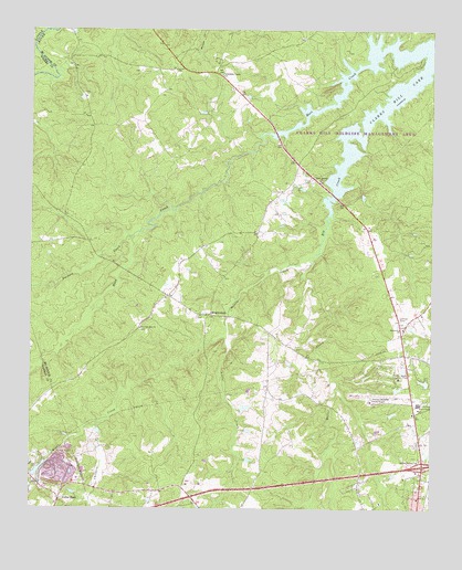
Wrightsboro, GA USGS Topographic Map
Click on map above to begin viewing in our Map Viewer.

This topographic map contains these locations and features:
Feature Name Type Latitude Longitude GNIS ID View Map
Anthony CrossroadsPopulated PlaceN33.5899°W82.5415°348744View Map
Belle Meade Country ClubLocaleN33.5340°W82.5096°344190View Map
Brinkley ChapelChurchN33.6135°W82.5651°311804View Map
Cedar RockPopulated PlaceN33.5026°W82.6154°331361View Map
Childers CreekStreamN33.5221°W82.6024°312638View Map
Columbia Mine (historical)Populated PlaceN33.6168°W82.5665°348752View Map
Exit 59CrossingN33.5112°W82.5024°1705037View Map
Factory CreekStreamN33.5710°W82.5932°355748View Map
Georgia State Patrol ThomsonBuildingN33.5250°W82.5074°2733718View Map
Green Branch ChurchChurchN33.5857°W82.5349°314824View Map
Hart CreekStreamN33.6207°W82.5026°356210View Map
Ivey CemeteryCemeteryN33.5051°W82.5837°348772View Map
Knox LakeReservoirN33.5332°W82.5020°339546View Map
Knox Lake DamDamN33.5335°W82.5015°339545View Map
Liberty Hill CemeteryCemeteryN33.5448°W82.5949°348775View Map
Liberty Hill Church (historical)ChurchN33.5449°W82.5946°348776View Map
Liberty Hill School (historical)SchoolN33.5454°W82.5943°348777View Map
Little CreekStreamN33.5443°W82.5637°317040View Map
Mattox CreekStreamN33.5657°W82.5365°356380View Map
McDuffie County Fire Department Station 2BuildingN33.5282°W82.5163°2604527View Map
Middle CreekStreamN33.5657°W82.5365°318068View Map
Moore CemeteryCemeteryN33.6085°W82.6085°348782View Map
New Zion Hill CemeteryCemeteryN33.5468°W82.5904°348786View Map
New Zion Hill ChurchChurchN33.5471°W82.5907°319564View Map
Pine Grove CemeteryCemeteryN33.5476°W82.5087°348801View Map
Pine Grove ChurchChurchN33.5471°W82.5085°320577View Map
Pleasant Grove CemeteryCemeteryN33.5437°W82.5473°348789View Map
Pleasant Grove ChurchChurchN33.5437°W82.5471°348792View Map
Rees-Wade-Short CemeteryCemeteryN33.5498°W82.5379°348805View Map
Savannah Valley Memorial GardenCemeteryN33.5171°W82.5040°348811View Map
Shaws BendBendN33.6224°W82.6221°348812View Map
Tatham Mines (historical)Populated PlaceN33.6229°W82.5399°348824View Map
Thomson DivisionCivilN33.5176°W82.5153°1936585View Map
Thomson-McDuffie County AirportAirportN33.5284°W82.5187°326833View Map
Three PointsPopulated PlaceN33.5315°W82.5507°348832View Map
Todds BranchStreamN33.5154°W82.5324°348833View Map
WrightsboroPopulated PlaceN33.5504°W82.5690°356652View Map
Wrightsboro CemeteryCemeteryN33.5501°W82.5721°348839View Map
Wrightsboro Methodist ChurchChurchN33.5504°W82.5721°348840View Map

Note: Coordinates in the location and feature list above are referenced to NAD83 datum.


Copyright (C) 2008-2025 Ryan Niemi / Sunset Dynamics ... All Rights Reserved