TopoQuest Logo
Do you find TopoQuest useful?
Help keep TopoQuest running and adding new maps/features by donating!
Bitcoin:  19c7KJd3qBynnjoSw5npx9KScwjBe4ifkT
Litecoin:  LXs6TkuXGGXo1vDsWCkWVdjQX94eUKd6ui
Home View Maps Find Maps Find Places Resources & Links


Cadley, Georgia Topographic Map

USGS Map Title: Cadley, GA
USGS Map MRC: 33082E6
DRG (GeoTIFF) Download: o33082e6.tif


Neighboring USGS Topographic Map Quads:


  Washington West, GA  
33082F7
 

  Washington East, GA  
33082F6
 

  Aonia, GA  
33082F5
 

  Sharon, GA  
33082E7
 

  Cadley, GA  
33082E6
 

  Wrightsboro, GA  
33082E5
 

  Sparta NE, GA  
33082D7
 

  Warrenton, GA  
33082D6
 

  Thomson West, GA  
33082D5


Map MRC Location:

N34°
W83°
N34°
W82°
H8 H7 H6 H5 H4 H3 H2 H1
G8 G7 G6 G5 G4 G3 G2 G1
F8 F7 F6 F5 F4 F3 F2 F1
E8 E7 E6 E5 E4 E3 E2 E1
D8 D7 D6 D5 D4 D3 D2 D1
C8 C7 C6 C5 C4 C3 C2 C1
B8 B7 B6 B5 B4 B3 B2 B1
A8 A7 A6 A5 A4 A3 A2 A1
N33°
W83°
N33°
W82°

Cadley, GA USGS 1:24K Topographic Map Preview:
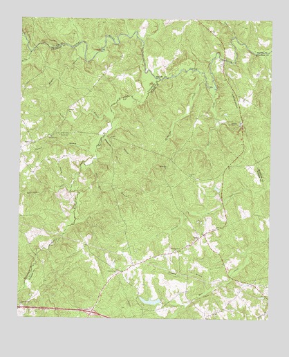
Cadley, GA USGS Topographic Map
Click on map above to begin viewing in our Map Viewer.

This topographic map contains these locations and features:
Feature Name Type Latitude Longitude GNIS ID View Map
Beaverdam CreekStreamN33.5543°W82.7237°311005View Map
Bull CreekStreamN33.5960°W82.6529°354905View Map
CadleyPopulated PlaceN33.5337°W82.6596°331304View Map
Camak DivisionCivilN33.5097°W82.6510°1936153View Map
Cedar CreekStreamN33.6182°W82.6432°312459View Map
Channel BranchStreamN33.5712°W82.7118°312558View Map
Cloud CemeteryCemeteryN33.5146°W82.6276°347679View Map
Dyers Mill (historical)LocaleN33.6085°W82.6490°348757View Map
Ebenezer Baptist Church (historical)ChurchN33.5199°W82.7004°347689View Map
Ebenezer CemeteryCemeteryN33.5196°W82.7004°313817View Map
Exit 57CrossingN33.5026°W82.7132°1705083View Map
Fountain CampgroundLocaleN33.5818°W82.6401°314306View Map
Friendship CemeteryCemeteryN33.5757°W82.7349°347621View Map
Friendship ChurchChurchN33.5751°W82.7357°355945View Map
Indian Hill ChurchChurchN33.5635°W82.6765°315905View Map
Mcbrayer Lake DamDamN33.5535°W82.6499°336412View Map
Morgan BranchStreamN33.6124°W82.7240°318453View Map
New Providence CemeteryCemeteryN33.5282°W82.6715°347739View Map
New Providence ChurchChurchN33.5287°W82.6718°319514View Map
North Prong Williams CreekStreamN33.5110°W82.7487°319667View Map
Ray DamDamN33.5085°W82.6799°336404View Map
Ray LakeReservoirN33.5074°W82.6835°336405View Map
Rays Chapel CemeteryCemeteryN33.5104°W82.7082°347749View Map
Raytown CemeteryCemeteryN33.5737°W82.7446°347640View Map
Raytown ChurchChurchN33.5737°W82.7440°321347View Map
Reedy CreekStreamN33.6110°W82.7446°321468View Map
Sardis BranchStreamN33.5862°W82.7046°322526View Map
Sardis CemeteryCemeteryN33.5865°W82.7257°347647View Map
Sardis ChurchChurchN33.5862°W82.7260°322547View Map
Shiloh CemeteryCemeteryN33.5376°W82.6515°347760View Map
Shiloh ChurchChurchN33.5379°W82.6510°322886View Map
Soapstone BranchStreamN33.5757°W82.7076°323207View Map
South Liberty Church CemeteryCemeteryN33.5765°W82.7307°323259View Map
Steep Hill BranchStreamN33.5640°W82.7140°323557View Map
Storks BendBendN33.6162°W82.6435°348819View Map
Tanyard BranchStreamN33.5121°W82.6551°323910View Map
ThigpenPopulated PlaceN33.5151°W82.6337°347771View Map
Whitesides CreekStreamN33.5987°W82.6574°325223View Map
Williams CreekStreamN33.5996°W82.6801°325352View Map
Williams Creek CemeteryCemeteryN33.5057°W82.7485°347782View Map
Williams Creek ChurchChurchN33.5060°W82.7485°325353View Map
Winn Oliver CemeteryCemeteryN33.5379°W82.6482°347786View Map
Woodruff BridgeBridgeN33.6085°W82.6485°348838View Map

Note: Coordinates in the location and feature list above are referenced to NAD83 datum.


Copyright (C) 2008-2025 Ryan Niemi / Sunset Dynamics ... All Rights Reserved