TopoQuest Logo
Do you find TopoQuest useful?
Help keep TopoQuest running and adding new maps/features by donating!
Bitcoin:  19c7KJd3qBynnjoSw5npx9KScwjBe4ifkT
Litecoin:  LXs6TkuXGGXo1vDsWCkWVdjQX94eUKd6ui
Home View Maps Find Maps Find Places Resources & Links


Wunpost, California Topographic Map

USGS Map Title: Wunpost, CA
USGS Map MRC: 35120H7
DRG (GeoTIFF) Download: o35120h7.tif


Neighboring USGS Topographic Map Quads:


  San Ardo, CA  
36120A8
 

  Pancho Rico Valley, CA  
36120A7
 

  Slack Canyon, CA  
36120A6
 

  Hames Valley, CA  
35120H8
 

  Wunpost, CA  
35120H7
 

  Valleton, CA  
35120H6
 

  Tierra Redonda Mountain, CA  
35120G8
 

  Bradley, CA  
35120G7
 

  San Miguel, CA  
35120G6


Map MRC Location:

N36°
W121°
N36°
W120°
H8 H7 H6 H5 H4 H3 H2 H1
G8 G7 G6 G5 G4 G3 G2 G1
F8 F7 F6 F5 F4 F3 F2 F1
E8 E7 E6 E5 E4 E3 E2 E1
D8 D7 D6 D5 D4 D3 D2 D1
C8 C7 C6 C5 C4 C3 C2 C1
B8 B7 B6 B5 B4 B3 B2 B1
A8 A7 A6 A5 A4 A3 A2 A1
N35°
W121°
N35°
W120°

Wunpost, CA USGS 1:24K Topographic Map Preview:
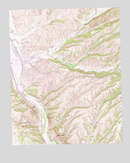
Wunpost, CA USGS Topographic Map
Click on map above to begin viewing in our Map Viewer.

This topographic map contains these locations and features:
Feature Name Type Latitude Longitude GNIS ID View Map
Deadman GulchValleyN35.9766°W120.8663°241324View Map
Dry GulchValleyN35.9872°W120.8321°241639View Map
Getty SidingLocaleN35.9719°W120.8746°242687View Map
Hames CreekStreamN35.8783°W120.8341°243138View Map
Lang CanyonValleyN35.9927°W120.7768°244578View Map
Lynch CanyonValleyN35.9819°W120.8527°245315View Map
Powell CanyonValleyN35.9619°W120.8338°247757View Map
Sarah CanyonValleyN35.8894°W120.8349°249153View Map
Sargent CanyonValleyN35.9508°W120.8630°249156View Map
Sargent CreekStreamN35.9511°W120.8632°249157View Map
Sargent School (historical)SchoolN35.9439°W120.7991°1670154View Map
Semas MountainSummitN35.8827°W120.8218°249262View Map
Sheep CanyonValleyN35.9461°W120.8021°249364View Map
Swain ValleyValleyN35.8922°W120.8388°250164View Map
Texaco-San Ardo HeliportAirportN35.9564°W120.8705°1653918View Map
Walker CanyonValleyN35.9752°W120.8016°251134View Map
WunpostPopulated PlaceN35.9311°W120.8632°1661712View Map

Note: Coordinates in the location and feature list above are referenced to NAD83 datum.


Copyright (C) 2008-2025 Ryan Niemi / Sunset Dynamics ... All Rights Reserved