TopoQuest Logo
Do you find TopoQuest useful?
Help keep TopoQuest running and adding new maps/features by donating!
Bitcoin:  19c7KJd3qBynnjoSw5npx9KScwjBe4ifkT
Litecoin:  LXs6TkuXGGXo1vDsWCkWVdjQX94eUKd6ui
Home View Maps Find Maps Find Places Resources & Links


Zelienople, Pennsylvania Topographic Map

USGS Map Title: Zelienople, PA
USGS Map MRC: 40080G2
DRG (GeoTIFF) Download: o40080g2.tif


Neighboring USGS Topographic Map Quads:


  New Castle South, PA  
40080H3
 

  Portersville, PA  
40080H2
 

  Prospect, PA  
40080H1
 

  Beaver Falls, PA  
40080G3
 

  Zelienople, PA  
40080G2
 

  Evans City, PA  
40080G1
 

  Beaver, PA  
40080F3
 

  Baden, PA  
40080F2
 

  Mars, PA  
40080F1


Map MRC Location:

N41°
W81°
N41°
W80°
H8 H7 H6 H5 H4 H3 H2 H1
G8 G7 G6 G5 G4 G3 G2 G1
F8 F7 F6 F5 F4 F3 F2 F1
E8 E7 E6 E5 E4 E3 E2 E1
D8 D7 D6 D5 D4 D3 D2 D1
C8 C7 C6 C5 C4 C3 C2 C1
B8 B7 B6 B5 B4 B3 B2 B1
A8 A7 A6 A5 A4 A3 A2 A1
N40°
W81°
N40°
W80°

Zelienople, PA USGS 1:24K Topographic Map Preview:
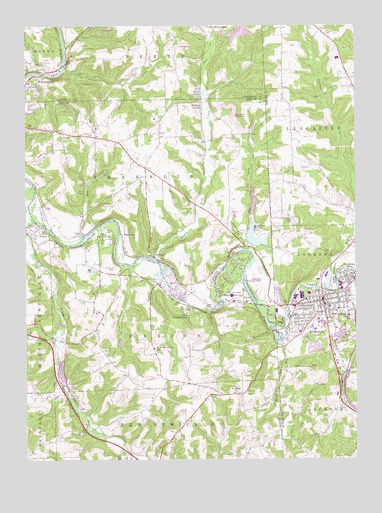
Zelienople, PA USGS Topographic Map
Click on map above to begin viewing in our Map Viewer.

This topographic map contains these locations and features:
Feature Name Type Latitude Longitude GNIS ID View Map
American SchoolSchoolN40.8442°W80.1689°1197713View Map
BarrisvillePopulated PlaceN40.7845°W80.2406°1197721View Map
Bates LakeLakeN40.8559°W80.1814°1168805View Map
Borough of HarmonyCivilN40.8014°W80.1251°1214994View Map
Borough of ZelienopleCivilN40.7886°W80.1428°1215007View Map
Brintons CornersPopulated PlaceN40.8528°W80.1820°1170269View Map
Brush CreekStreamN40.8192°W80.2470°1170439View Map
Buck RunStreamN40.8126°W80.1670°1170541View Map
Burns CemeteryCemeteryN40.7509°W80.1966°1170731View Map
Camp CarondowannaLocaleN40.7923°W80.1895°1170988View Map
Camp Kon-O-KweeLocaleN40.8156°W80.2181°1171044View Map
Camp RunStreamN40.8081°W80.2012°1171082View Map
Camp Run CemeteryCemeteryN40.8426°W80.1692°1171084View Map
CeliaPopulated PlaceN40.8151°W80.2287°1171409View Map
Connoquenessing Valley Elementary SchoolSchoolN40.7931°W80.1267°1172355View Map
Doe RunStreamN40.8101°W80.1667°1173339View Map
FombellPopulated PlaceN40.8095°W80.2017°1174937View Map
Franklin Township Police DepartmentBuildingN40.8350°W80.2050°2780491View Map
Franklin Township Volunteer Fire Department Station 70 - 2BuildingN40.8350°W80.2052°2645781View Map
Furnace SchoolSchoolN40.8128°W80.1678°1197715View Map
Glade RunStreamN40.7887°W80.1509°1175655View Map
GoehringPopulated PlaceN40.8151°W80.2131°1175775View Map
HarmonyPopulated PlaceN40.8015°W80.1273°1176545View Map
Harmony Emergency Medical ServicesBuildingN40.8084°W80.1299°2719534View Map
Harmony Volunteer Fire Company Station 23BuildingN40.8022°W80.1273°2645346View Map
Hartzell SchoolSchoolN40.7870°W80.2023°1197719View Map
HazenPopulated PlaceN40.8167°W80.2451°1176716View Map
Hazen RunStreamN40.8140°W80.2281°1176718View Map
Hereford Manor LakeReservoirN40.8116°W80.1621°1176868View Map
LillyvillePopulated PlaceN40.8442°W80.2365°1179342View Map
Lillyville Church of God CemeteryCemeteryN40.8396°W80.2341°2776016View Map
Lillyville Lutheran CemeteryCemeteryN40.8438°W80.2262°2776017View Map
Lower Hereford Manor DamDamN40.8117°W80.1648°1195053View Map
Marion Township Police DepartmentBuildingN40.7809°W80.2007°2780582View Map
Mellons SchoolSchoolN40.7612°W80.2267°1197718View Map
Muntz RunStreamN40.7837°W80.1526°1182100View Map
North East Beaver County SchoolSchoolN40.7823°W80.2009°1182571View Map
Old FurnacePopulated PlaceN40.7953°W80.1701°1213306View Map
Pine Valley Bible CampLocaleN40.8141°W80.2474°2431789View Map
Pyles MillsPopulated PlaceN40.8745°W80.1773°1204453View Map
Saint Johns Burrys Church CemeteryCemeteryN40.7694°W80.1718°2776029View Map
Saint Johns ChurchChurchN40.7695°W80.1709°1186141View Map
Schiever SchoolSchoolN40.8356°W80.1417°1197714View Map
Scholars RunStreamN40.7992°W80.1348°1187096View Map
Teets SchoolSchoolN40.7562°W80.1626°1197717View Map
Tollgate SchoolSchoolN40.7740°W80.1289°1197716View Map
Township of FranklinCivilN40.8310°W80.2060°1215872View Map
Township of MarionCivilN40.7892°W80.2031°1215878View Map
Wurtemburg CemeteryCemeteryN40.8634°W80.2444°1191817View Map
ZelienoplePopulated PlaceN40.7945°W80.1367°1191943View Map
Zelienople Borough Police DepartmentBuildingN40.7958°W80.1379°2777131View Map
Zelienople Borough Volunteer Fire Department Station 22BuildingN40.7866°W80.1441°2644892View Map
Zelienople Municipal AirportAirportN40.7977°W80.1613°1194105View Map
Zelienople Post OfficePost OfficeN40.7929°W80.1368°2779977View Map

Note: Coordinates in the location and feature list above are referenced to NAD83 datum.


Copyright (C) 2008-2025 Ryan Niemi / Sunset Dynamics ... All Rights Reserved