TopoQuest Logo
Do you find TopoQuest useful?
Help keep TopoQuest running and adding new maps/features by donating!
Bitcoin:  19c7KJd3qBynnjoSw5npx9KScwjBe4ifkT
Litecoin:  LXs6TkuXGGXo1vDsWCkWVdjQX94eUKd6ui
Home View Maps Find Maps Find Places Resources & Links


Zenobia Peak, Colorado Topographic Map

USGS Map Title: Zenobia Peak, CO
USGS Map MRC: 40108E7
DRG (GeoTIFF) Download: o40108e7.tif


Neighboring USGS Topographic Map Quads:


  Canyon of Lodore North, CO  
40108F8
 

  Jack Springs, CO  
40108F7
 

  Vermillion Mesa, CO  
40108F6
 

  Canyon of Lodore South, CO  
40108E8
 

  Zenobia Peak, CO  
40108E7
 

  Greystone, CO  
40108E6
 

  Hells Canyon, CO  
40108D8
 

  Tanks Peak, CO  
40108D7
 

  Haystack Rock, CO  
40108D6


Map MRC Location:

N41°
W109°
N41°
W108°
H8 H7 H6 H5 H4 H3 H2 H1
G8 G7 G6 G5 G4 G3 G2 G1
F8 F7 F6 F5 F4 F3 F2 F1
E8 E7 E6 E5 E4 E3 E2 E1
D8 D7 D6 D5 D4 D3 D2 D1
C8 C7 C6 C5 C4 C3 C2 C1
B8 B7 B6 B5 B4 B3 B2 B1
A8 A7 A6 A5 A4 A3 A2 A1
N40°
W109°
N40°
W108°

Zenobia Peak, CO USGS 1:24K Topographic Map Preview:
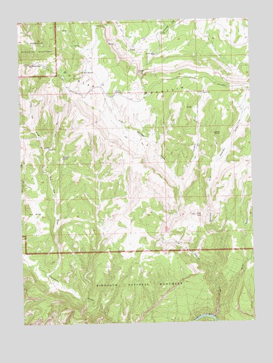
Zenobia Peak, CO USGS Topographic Map
Click on map above to begin viewing in our Map Viewer.

This topographic map contains these locations and features:
Feature Name Type Latitude Longitude GNIS ID View Map
Ant HillsRangeN40.5486°W108.8729°201952View Map
Big Joe DrawValleyN40.5201°W108.8616°170651View Map
Browns CabinLocaleN40.5725°W108.8604°170644View Map
Buck DrawValleyN40.5060°W108.7704°170655View Map
Chicken SpringsSpringN40.5955°W108.8240°170648View Map
Cove DamDamN40.6233°W108.7807°200002View Map
Cove ReservoirReservoirN40.6233°W108.7807°200003View Map
Currant Springs RanchLocaleN40.6111°W108.8021°170649View Map
Douglas Mountain MineMineN40.5658°W108.7543°1683125View Map
Five SpringSpringN40.6039°W108.8406°170650View Map
Five Springs DrawValleyN40.5019°W108.7732°170642View Map
Hillside SpringSpringN40.5689°W108.8530°170643View Map
Holland DrawValleyN40.5582°W108.7894°170646View Map
Little Joe DrawValleyN40.5720°W108.8622°170652View Map
Paint Iron MineMineN40.5661°W108.7518°1683126View Map
Peterson DrawValleyN40.5219°W108.7748°170640View Map
Peterson ValleyValleyN40.5666°W108.7692°170656View Map
Queen Anne and Black Sioux MineMineN40.5880°W108.8679°1683127View Map
Redfern SpringSpringN40.5777°W108.7707°170645View Map
Reds KnobSummitN40.5444°W108.7812°170641View Map
Tisdels PlaceLocaleN40.5947°W108.7768°170647View Map
Zenobia PeakSummitN40.6069°W108.8701°170653View Map

Note: Coordinates in the location and feature list above are referenced to NAD83 datum.


Copyright (C) 2008-2025 Ryan Niemi / Sunset Dynamics ... All Rights Reserved