TopoQuest Logo
Do you find TopoQuest useful?
Help keep TopoQuest running and adding new maps/features by donating!
Bitcoin:  19c7KJd3qBynnjoSw5npx9KScwjBe4ifkT
Litecoin:  LXs6TkuXGGXo1vDsWCkWVdjQX94eUKd6ui
Home View Maps Find Maps Find Places Resources & Links


Brace Flat, Idaho Topographic Map

USGS Map Title: Brace Flat, ID
USGS Map MRC: 42116C6
DRG (GeoTIFF) Download: o42116c6.tif


Neighboring USGS Topographic Map Quads:


  Smith Creek, ID  
42116D7
 

  Castro Table, ID  
42116D6
 

  Dickshooter Reservoir, ID  
42116D5
 

  Red Basin, ID  
42116C7
 

  Brace Flat, ID  
42116C6
 

  Dickshooter Ridge, ID  
42116C5
 

  Grassy Ridge, ID  
42116B7
 

  Piute Basin West, ID  
42116B6
 

  Piute Basin East, ID  
42116B5


Map MRC Location:

N43°
W117°
N43°
W116°
H8 H7 H6 H5 H4 H3 H2 H1
G8 G7 G6 G5 G4 G3 G2 G1
F8 F7 F6 F5 F4 F3 F2 F1
E8 E7 E6 E5 E4 E3 E2 E1
D8 D7 D6 D5 D4 D3 D2 D1
C8 C7 C6 C5 C4 C3 C2 C1
B8 B7 B6 B5 B4 B3 B2 B1
A8 A7 A6 A5 A4 A3 A2 A1
N42°
W117°
N42°
W116°

Brace Flat, ID USGS 1:24K Topographic Map Preview:
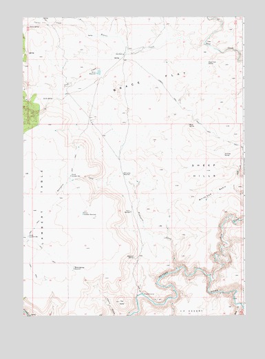
Brace Flat, ID USGS Topographic Map
Click on map above to begin viewing in our Map Viewer.

This topographic map contains these locations and features:
Feature Name Type Latitude Longitude GNIS ID View Map
Antelope SpringSpringN42.3172°W116.6366°371268View Map
Beaver CreekStreamN42.3646°W116.6476°371418View Map
Brace DamDamN42.3532°W116.7076°398692View Map
Brace FlatFlatN42.3457°W116.6757°371677View Map
Brace RanchLocaleN42.3596°W116.6943°371678View Map
Brace ReservoirReservoirN42.3518°W116.7073°397476View Map
Carter CreekStreamN42.3668°W116.7048°371900View Map
Carter SpringSpringN42.3714°W116.7465°371901View Map
Center Lambert ReservoirReservoirN42.2928°W116.7163°371950View Map
Deep CreekStreamN42.2646°W116.6435°399851View Map
Deep Creek SpringSpringN42.3556°W116.6455°372354View Map
Kettle SpringSpringN42.3408°W116.7331°373402View Map
North Lambert ReservoirReservoirN42.3087°W116.7233°374220View Map
Piute CreekStreamN42.2546°W116.6276°374429View Map
Porcupine CreekStreamN42.2688°W116.6632°374500View Map
Porcupine ReservoirReservoirN42.3094°W116.6938°374503View Map
Rickard CrossingPopulated PlaceN42.2588°W116.6826°397099View Map
Ryegrass SpringSpringN42.2746°W116.6877°374823View Map
Sheep HillsRangeN42.3107°W116.6460°374987View Map
Sheep SpringSpringN42.3298°W116.6563°374992View Map
South Lambert ReservoirReservoirN42.2833°W116.7470°375165View Map
The DomeSummitN42.2557°W116.6962°375465View Map
Trap CreekStreamN42.3607°W116.6907°375572View Map
Twin SpringsSpringN42.2935°W116.6896°375642View Map
Twin Springs RanchLocaleN42.2943°W116.6882°399236View Map
Warm Springs ReservoirReservoirN42.2697°W116.7214°375744View Map
White Cow BasinBasinN42.3016°W116.6410°375859View Map

Note: Coordinates in the location and feature list above are referenced to NAD83 datum.


Copyright (C) 2008-2024 Ryan Niemi / Sunset Dynamics ... All Rights Reserved