TopoQuest Logo
Do you find TopoQuest useful?
Help keep TopoQuest running and adding new maps/features by donating!
Bitcoin:  19c7KJd3qBynnjoSw5npx9KScwjBe4ifkT
Litecoin:  LXs6TkuXGGXo1vDsWCkWVdjQX94eUKd6ui
Home View Maps Find Maps Find Places Resources & Links


Bradfordsville NE, Kentucky Topographic Map

USGS Map Title: Bradfordsville NE, KY
USGS Map MRC: 37085D1
DRG (GeoTIFF) Download: o37085d1.tif


Neighboring USGS Topographic Map Quads:


  Lebanon East, KY  
37085E2
 

  Gravel Switch, KY  
37085E1
 

  Parksville, KY  
37084E8
 

  Bradfordsville, KY  
37085D2
 

  Bradfordsville NE, KY  
37085D1
 

  Ellisburg, KY  
37084D8
 

  Mannsville, KY  
37085C2
 

  Clementsville, KY  
37085C1
 

  Liberty, KY  
37084C8


Map MRC Location:

N38°
W86°
N38°
W85°
H8 H7 H6 H5 H4 H3 H2 H1
G8 G7 G6 G5 G4 G3 G2 G1
F8 F7 F6 F5 F4 F3 F2 F1
E8 E7 E6 E5 E4 E3 E2 E1
D8 D7 D6 D5 D4 D3 D2 D1
C8 C7 C6 C5 C4 C3 C2 C1
B8 B7 B6 B5 B4 B3 B2 B1
A8 A7 A6 A5 A4 A3 A2 A1
N37°
W86°
N37°
W85°

Bradfordsville NE, KY USGS 1:24K Topographic Map Preview:
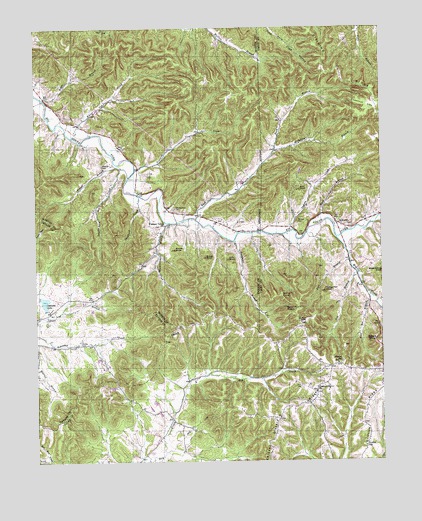
Bradfordsville NE, KY USGS Topographic Map
Click on map above to begin viewing in our Map Viewer.

This topographic map contains these locations and features:
Feature Name Type Latitude Longitude GNIS ID View Map
Atwood SchoolSchoolN37.4034°W85.0161°486132View Map
Bald KnobSummitN37.4534°W85.0286°486271View Map
Bald Knob GraveyardCemeteryN37.4533°W85.0287°2568322View Map
Bradfordsville DivisionCivilN37.4754°W85.1204°1936885View Map
Buck BranchStreamN37.4440°W85.0250°488189View Map
Button KnobSummitN37.4153°W85.0291°517328View Map
Button Knob Lookout TowerTowerN37.4149°W85.0293°2568343View Map
Button RidgeRidgeN37.4153°W85.0273°2742271View Map
Chestnut FlatFlatN37.4770°W85.0047°489425View Map
Chestnut Grove Church (historical)ChurchN37.3950°W85.0241°489438View Map
Cox BranchStreamN37.4295°W85.0086°490214View Map
Drye GraveyardCemeteryN37.4432°W85.0103°2568371View Map
Ellis GapGapN37.4250°W85.0956°2742654View Map
Ellis KnobSummitN37.4337°W85.0544°491718View Map
Evans KnobSummitN37.4340°W85.0625°491838View Map
Fort BranchStreamN37.4331°W85.0113°492352View Map
Griffith RidgeRidgeN37.3881°W85.0063°493390View Map
Griffith SchoolSchoolN37.3792°W85.0066°493391View Map
Hale HollowValleyN37.4998°W85.0395°493555View Map
Hazel PointRidgeN37.4187°W85.0358°507351View Map
Indian CreekStreamN37.4420°W85.0316°494920View Map
JacktownPopulated PlaceN37.4440°W85.0155°508329View Map
Malone CemeteryCemeteryN37.4440°W85.0300°497474View Map
Martin CreekStreamN37.4398°W85.0161°497615View Map
McAnelly BranchStreamN37.4648°W85.0372°497763View Map
McFarland SchoolSchoolN37.3906°W85.0266°497853View Map
Needmore BranchStreamN37.4390°W85.0522°499221View Map
Oakland LakeReservoirN37.4213°W85.1219°499746View Map
Peavy CemeteryCemeteryN37.3965°W85.0294°500494View Map
Peck Post Office (historical)Post OfficeN37.3901°W85.0864°2568445View Map
Pine Grove (historical)Populated PlaceN37.3842°W85.0698°2742276View Map
Pine Grove Baptist Church CemeteryCemeteryN37.3850°W85.0688°2568452View Map
Pine Grove SchoolSchoolN37.3853°W85.0702°500690View Map
Pleasant Valley ChurchChurchN37.4434°W85.0777°500932View Map
Rakes BranchStreamN37.4798°W85.1216°501538View Map
Round KnobSummitN37.4362°W85.0738°502404View Map
Rush BranchStreamN37.4451°W85.0661°502477View Map
Rush Branch (historical)Populated PlaceN37.4484°W85.0651°2566891View Map
Rush Branch Post Office (historical)Post OfficeN37.4456°W85.0660°2566892View Map
Scuffle CreekStreamN37.4609°W85.0947°503126View Map
Seths KnobSummitN37.4212°W85.0400°507350View Map
Shepherd CreekStreamN37.4520°W85.0866°503347View Map
Shreve CemeteryCemeteryN37.4092°W85.1091°503465View Map
South Fork Church (historical)ChurchN37.4702°W85.1044°2566904View Map
Stacy FallsFallsN37.4140°W85.0352°507320View Map
Steele KnobSummitN37.4101°W85.0030°504310View Map
Traverse CreekStreamN37.4598°W85.0883°505473View Map
Turkey Pen KnobSummitN37.4242°W85.0200°505621View Map
Wayman CemeteryCemeteryN37.4609°W85.1005°506310View Map
Weatherford CemeteryCemeteryN37.4484°W85.0741°506314View Map
Wess Post Office (historical)Post OfficeN37.4023°W85.0187°2568501View Map
Whippoorwill (historical)Populated PlaceN37.4277°W85.0794°2547940View Map
Whippoorwill BranchStreamN37.4445°W85.0772°506552View Map
White Oak CreekStreamN37.4690°W85.1116°506611View Map
Wolf Pen BranchStreamN37.4231°W85.0044°507019View Map
Yowell BranchStreamN37.4606°W85.0947°507261View Map

Note: Coordinates in the location and feature list above are referenced to NAD83 datum.


Copyright (C) 2008-2024 Ryan Niemi / Sunset Dynamics ... All Rights Reserved