TopoQuest Logo
Do you find TopoQuest useful?
Help keep TopoQuest running and adding new maps/features by donating!
Bitcoin:  19c7KJd3qBynnjoSw5npx9KScwjBe4ifkT
Litecoin:  LXs6TkuXGGXo1vDsWCkWVdjQX94eUKd6ui
Home View Maps Find Maps Find Places Resources & Links


Breckenridge Mountain, California Topographic Map

USGS Map Title: Breckenridge Mountain, CA
USGS Map MRC: 35118D5
DRG (GeoTIFF) Download: o35118d5.tif


Neighboring USGS Topographic Map Quads:


  Democrat Hot Springs, CA  
35118E6
 

  Miracle Hot Springs, CA  
35118E5
 

  Lake Isabella South, CA  
35118E4
 

  Mount Adelaide, CA  
35118D6
 

  Breckenridge Mountain, CA  
35118D5
 

  Piute Peak, CA  
35118D4
 

  Bena, CA  
35118C6
 

  Oiler Peak, CA  
35118C5
 

  Loraine, CA  
35118C4


Map MRC Location:

N36°
W119°
N36°
W118°
H8 H7 H6 H5 H4 H3 H2 H1
G8 G7 G6 G5 G4 G3 G2 G1
F8 F7 F6 F5 F4 F3 F2 F1
E8 E7 E6 E5 E4 E3 E2 E1
D8 D7 D6 D5 D4 D3 D2 D1
C8 C7 C6 C5 C4 C3 C2 C1
B8 B7 B6 B5 B4 B3 B2 B1
A8 A7 A6 A5 A4 A3 A2 A1
N35°
W119°
N35°
W118°

Breckenridge Mountain, CA USGS 1:24K Topographic Map Preview:
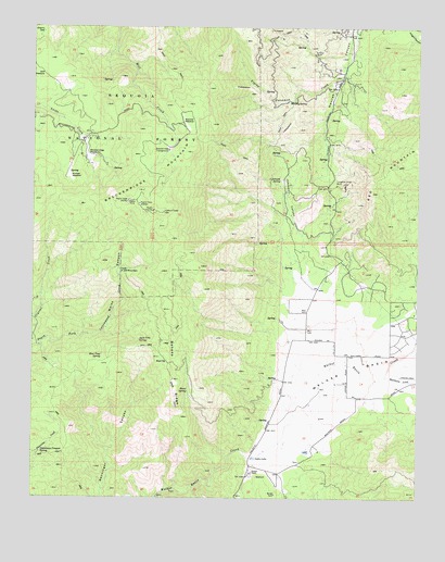
Breckenridge Mountain, CA USGS Topographic Map
Click on map above to begin viewing in our Map Viewer.

This topographic map contains these locations and features:
Feature Name Type Latitude Longitude GNIS ID View Map
Agua Fria SpringSpringN35.4169°W118.5913°269443View Map
Banada RidgeRidgeN35.4086°W118.5809°269661View Map
Barrel SpringSpringN35.4763°W118.5912°1653172View Map
Bear Trap SpringSpringN35.4131°W118.6034°269757View Map
BreckenridgeLocaleN35.4680°W118.6073°275103View Map
Breckenridge CampgroundLocaleN35.4675°W118.5829°270012View Map
Breckenridge Fire TowerLocaleN35.4508°W118.5837°1653173View Map
Breckenridge LodgeBuildingN35.4661°W118.6106°1653174View Map
Breckenridge MeadowsFlatN35.4661°W118.6090°270013View Map
Breckenridge MeadowsFlatN35.4663°W118.6056°1652936View Map
Breckenridge MountainSummitN35.4511°W118.5843°270014View Map
Breckenridge Mountain LookoutLocaleN35.4477°W118.6087°275119View Map
Bull FlatFlatN35.4108°W118.5837°270076View Map
Cherry GapGapN35.4991°W118.6229°270404View Map
Deer SpringsSpringN35.4477°W118.6087°275120View Map
Dutchman Prospect SpringSpringN35.3873°W118.6228°270954View Map
Flying Dutchman CreekStreamN35.4863°W118.5268°271163View Map
Flying S Ranch AirportAirportN35.4083°W118.5036°1653301View Map
Golf MeadowFlatN35.4872°W118.6223°271349View Map
Hole in the MountainSummitN35.4350°W118.5981°1660755View Map
Home SpringSpringN35.4034°W118.5754°271611View Map
Johns RanchLocaleN35.4011°W118.5206°275115View Map
Johnson CanyonValleyN35.4475°W118.5415°271802View Map
Johnson SpringSpringN35.4595°W118.5458°271811View Map
Julia LakeReservoirN35.3855°W118.5538°244164View Map
KBAK-TV (Bakersfield)TowerN35.4530°W118.5912°1663151View Map
KERO-TV (Bakersfield)TowerN35.4538°W118.5945°1663150View Map
Knox RanchLocaleN35.4855°W118.5279°1652938View Map
Lazells RanchLocaleN35.4925°W118.5231°1652939View Map
Lightner RanchLocaleN35.3891°W118.5354°275118View Map
Metoe SpringSpringN35.4758°W118.5904°275102View Map
Munzer MeadowFlatN35.4602°W118.6143°272603View Map
Murphy SpringSpringN35.4804°W118.5426°272606View Map
Rancheria CreekStreamN35.4075°W118.5115°273187View Map
Rankin RanchLocaleN35.3819°W118.5545°273205View Map
Shead RanchLocaleN35.4525°W118.5293°1653178View Map
Shead RanchLocaleN35.4525°W118.5237°1652937View Map
Squirrel MeadowFlatN35.4744°W118.5779°273884View Map
Tungsten Chief MillLocaleN35.4122°W118.5312°1652935View Map
Tungsten Chief Mill (historical)LocaleN35.4291°W118.5306°1653179View Map
Tungsten Chief MineMineN35.4583°W118.5281°274222View Map
Walker BasinBasinN35.4097°W118.5223°274366View Map
Walker Basin School (historical)SchoolN35.4127°W118.5240°1839147View Map
Weiss CanyonValleyN35.4191°W118.6031°274410View Map
Williams RanchLocaleN35.4205°W118.5284°1652934View Map

Note: Coordinates in the location and feature list above are referenced to NAD83 datum.


Copyright (C) 2008-2025 Ryan Niemi / Sunset Dynamics ... All Rights Reserved