TopoQuest Logo
Do you find TopoQuest useful?
Help keep TopoQuest running and adding new maps/features by donating!
Bitcoin:  19c7KJd3qBynnjoSw5npx9KScwjBe4ifkT
Litecoin:  LXs6TkuXGGXo1vDsWCkWVdjQX94eUKd6ui
Home View Maps Find Maps Find Places Resources & Links


Bridgeport, Alabama Topographic Map

USGS Map Title: Bridgeport, AL
USGS Map MRC: 34085H6
DRG (GeoTIFF) Download: o34085h6.tif


Neighboring USGS Topographic Map Quads:


  Orme, TN  
35085A7
 

  South Pittsburg, TN  
35085A6
 

  Sequatchie, TN  
35085A5
 

  Doran Cove, AL  
34085H7
 

  Bridgeport, AL  
34085H6
 

  New Home, GA  
34085H5
 

  Stevenson, AL  
34085G7
 

  Flat Rock, AL  
34085G6
 

  Trenton, GA  
34085G5


Map MRC Location:

N35°
W86°
N35°
W85°
H8 H7 H6 H5 H4 H3 H2 H1
G8 G7 G6 G5 G4 G3 G2 G1
F8 F7 F6 F5 F4 F3 F2 F1
E8 E7 E6 E5 E4 E3 E2 E1
D8 D7 D6 D5 D4 D3 D2 D1
C8 C7 C6 C5 C4 C3 C2 C1
B8 B7 B6 B5 B4 B3 B2 B1
A8 A7 A6 A5 A4 A3 A2 A1
N34°
W86°
N34°
W85°

Bridgeport, AL USGS 1:24K Topographic Map Preview:
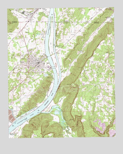
Bridgeport, AL USGS Topographic Map
Click on map above to begin viewing in our Map Viewer.

This topographic map contains these locations and features:
Feature Name Type Latitude Longitude GNIS ID View Map
Abbott CemeteryCemeteryN34.9412°W85.7341°112884View Map
Barton PointCapeN34.9265°W85.6750°113533View Map
Battery HillPopulated PlaceN34.9529°W85.7083°113574View Map
Beene CemeteryCemeteryN34.9976°W85.7175°1276878View Map
Big Culvert CreekStreamN34.9620°W85.6944°114273View Map
Blue HoleLakeN34.9937°W85.7147°1277761View Map
BridgeportPopulated PlaceN34.9476°W85.7144°114905View Map
Bridgeport Baptist ChurchChurchN34.9465°W85.7169°139107View Map
Bridgeport BarBarN34.9570°W85.6944°139108View Map
Bridgeport Community ParkParkN34.9406°W85.7061°139109View Map
Bridgeport Elementary SchoolSchoolN34.9401°W85.7206°139110View Map
Bridgeport High SchoolSchoolN34.9437°W85.7147°139111View Map
Bridgeport Police DepartmentBuildingN34.9487°W85.7135°2752037View Map
Bridgeport Post OfficePost OfficeN34.9402°W85.7268°2770174View Map
Bridgeport United Methodist ChurchChurchN34.9479°W85.7152°139112View Map
Bridgeport Volunteer Fire DepartmentBuildingN34.9485°W85.7156°2682972View Map
BryantPopulated PlaceN34.9437°W85.6322°115080View Map
Bryant ChurchChurchN34.9395°W85.6591°115087View Map
Bryant Community CenterLocaleN34.9473°W85.6525°115088View Map
Bryant GapGapN34.9423°W85.6622°115090View Map
Bryant Junior High SchoolSchoolN34.9387°W85.6272°139116View Map
Bryant Post OfficePost OfficeN34.9351°W85.6272°2770175View Map
Bryant TabernacleChurchN34.9204°W85.6366°115095View Map
City of BridgeportCivilN34.9495°W85.7243°2403924View Map
Concord ChurchChurchN34.9242°W85.7269°116502View Map
Concord School (historical)SchoolN34.9237°W85.7272°139141View Map
Copenhagen (historical)Populated PlaceN34.9842°W85.7250°139143View Map
Cresent Hill SchoolSchoolN34.9204°W85.6633°139146View Map
Crooked BranchStreamN34.8795°W85.7494°157927View Map
Ebenezer CemeteryCemeteryN34.9373°W85.6252°117816View Map
First Baptist ChurchChurchN34.9559°W85.7189°139164View Map
First Baptist Church of BridgeportChurchN34.9467°W85.7214°139165View Map
Gibson CoveValleyN34.9059°W85.6936°157965View Map
Glendale ChurchChurchN34.9140°W85.6377°119036View Map
Glover CreekStreamN34.9373°W85.6880°119057View Map
Graham BranchStreamN34.9995°W85.6486°119210View Map
Graham CemeteryCemeteryN34.9954°W85.6452°1285797View Map
Gray CemeteryCemeteryN34.8895°W85.6966°119293View Map
Gray SpringSpringN34.8892°W85.6931°119298View Map
Gross BranchStreamN34.8904°W85.6886°119438View Map
Harris ChapelChurchN34.9579°W85.6650°119801View Map
Hembrees BarBarN34.9173°W85.7000°139184View Map
Hembrees Landing (historical)LocaleN34.9173°W85.6950°139185View Map
Hicks PointCapeN34.8929°W85.6730°120042View Map
Hogjaw RidgeRidgeN34.9692°W85.6661°120207View Map
Hogjaw RidgeRidgeN34.9904°W85.6411°1288005View Map
Hogjaw ValleyValleyN34.9363°W85.6834°120208View Map
Horn BranchStreamN34.9034°W85.7458°120396View Map
Indian Hill Farm AirportAirportN34.9914°W85.6503°1301292View Map
Irondale BranchStreamN34.9637°W85.7289°120703View Map
Irondale Volunteer Fire DepartmentBuildingN34.9988°W85.7370°2654586View Map
Island BarBarN34.9398°W85.6889°139191View Map
Island Creek Ferry (historical)CrossingN34.9012°W85.7161°139192View Map
James CemeteryCemeteryN34.9742°W85.6619°120805View Map
Jones CreekStreamN34.9726°W85.7055°112858View Map
King CoveValleyN34.9712°W85.7490°121220View Map
Kirkpatrick CemeteryCemeteryN34.9729°W85.7344°121256View Map
Lary CreekStreamN34.9170°W85.6508°121402View Map
Lively CreekStreamN34.8762°W85.6369°152128View Map
Long Hollow BranchStreamN34.9742°W85.6941°122011View Map
Long IslandIslandN34.9615°W85.6991°152148View Map
Long IslandPopulated PlaceN34.9737°W85.6711°154472View Map
Long IslandIslandN34.9887°W85.6969°1291979View Map
Long Island CoveValleyN34.8990°W85.7139°122014View Map
Long Island CreekStreamN34.8990°W85.7139°152149View Map
Long Island School (historical)SchoolN34.9734°W85.6644°148782View Map
Loyd CemeteryCemeteryN34.9462°W85.7400°122095View Map
McDaniel Chapel (historical)ChurchN34.9959°W85.6372°1310061View Map
McDaniel-Moore CemeteryCemeteryN34.9956°W85.6375°1293245View Map
Moore Chapel (historical)ChurchN34.8792°W85.6861°139221View Map
Moore Chapel CemeteryCemeteryN34.8779°W85.6852°123007View Map
Moore CrossingLocaleN34.9981°W85.6397°1315535View Map
Mount Perron Church (historical)ChurchN34.9551°W85.6308°139225View Map
Mountain View ChurchChurchN34.9023°W85.6297°123535View Map
Patton HollowValleyN34.9929°W85.7364°1296980View Map
Poplar Spring BranchStreamN34.9906°W85.7014°1298227View Map
Porter BluffCliffN34.9592°W85.6480°125178View Map
Potato Hill CemeteryCemeteryN34.9031°W85.6300°125204View Map
Reese FerryCrossingN34.9256°W85.6939°114906View Map
Reese Ferry LandingLocaleN34.9242°W85.6911°139257View Map
Rexton PointCapeN34.9865°W85.7486°125577View Map
Rhodes GulfValleyN34.8801°W85.6725°125586View Map
Richard CityPopulated PlaceN34.9942°W85.7250°1299326View Map
Richard City Church of ChristChurchN34.9945°W85.7216°1317601View Map
Richard City Cumberland Presbyterian ChurchChurchN34.9945°W85.7211°1650847View Map
Richard City First Baptist ChurchChurchN34.9940°W85.7230°1643741View Map
Richard City Industrial ParkLocaleN34.9959°W85.7314°1310083View Map
Richard Hardy Memorial SchoolSchoolN34.9954°W85.7205°1317602View Map
Richards CemeteryCemeteryN34.9912°W85.7364°1299328View Map
Rock Spring Post Office (historical)Post OfficeN34.9312°W85.7491°166089View Map
Sally Lourey ReservationParkN34.9820°W85.7305°126260View Map
Straightway CemeteryCemeteryN34.9565°W85.6294°127452View Map
Straightway ChurchChurchN34.9515°W85.6336°127453View Map
Tennessee River Institute (historical)SchoolN34.9456°W85.7200°139300View Map
Tri - Community Volunteer Fire Department Bryant StationBuildingN34.9151°W85.6388°2683366View Map
Tri - Community Volunteer Fire Department Bryant Station 2BuildingN34.9217°W85.6382°2683356View Map
Upper BarBarN34.9846°W85.6978°139304View Map
Walker Family CemeteryCemeteryN34.9326°W85.7489°149601View Map
WBTS-AM (Bridgeport)TowerN34.9429°W85.7072°161108View Map
Widows BarBarN34.8904°W85.7339°139314View Map
Widows CreekStreamN34.8898°W85.7430°153985View Map
Williams CemeteryCemeteryN34.9045°W85.7355°129011View Map
Williams Landing (historical)LocaleN34.9026°W85.7177°139316View Map

Note: Coordinates in the location and feature list above are referenced to NAD83 datum.


Copyright (C) 2008-2024 Ryan Niemi / Sunset Dynamics ... All Rights Reserved