TopoQuest Logo
Do you find TopoQuest useful?
Help keep TopoQuest running and adding new maps/features by donating!
Bitcoin:  19c7KJd3qBynnjoSw5npx9KScwjBe4ifkT
Litecoin:  LXs6TkuXGGXo1vDsWCkWVdjQX94eUKd6ui
Home View Maps Find Maps Find Places Resources & Links


Bridgton, Maine Topographic Map

USGS Map Title: Bridgton, ME
USGS Map MRC: 44070A6
DRG (GeoTIFF) Download: o44070a6.tif


Neighboring USGS Topographic Map Quads:


  North Waterford, ME  
44070B7
 

  Waterford Flat, ME  
44070B6
 

  Norway, ME  
44070B5
 

  Pleasant Mountain, ME  
44070A7
 

  Bridgton, ME  
44070A6
 

  Casco, ME  
44070A5
 

  Hiram, ME  
43070H7
 

  North Sebago, ME  
43070H6
 

  Naples, ME  
43070H5


Map MRC Location:

N45°
W71°
N45°
W70°
H8 H7 H6 H5 H4 H3 H2 H1
G8 G7 G6 G5 G4 G3 G2 G1
F8 F7 F6 F5 F4 F3 F2 F1
E8 E7 E6 E5 E4 E3 E2 E1
D8 D7 D6 D5 D4 D3 D2 D1
C8 C7 C6 C5 C4 C3 C2 C1
B8 B7 B6 B5 B4 B3 B2 B1
A8 A7 A6 A5 A4 A3 A2 A1
N44°
W71°
N44°
W70°

Bridgton, ME USGS 1:24K Topographic Map Preview:
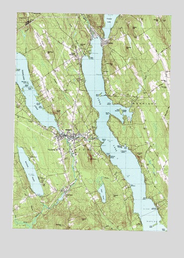
Bridgton, ME USGS Topographic Map
Click on map above to begin viewing in our Map Viewer.

This topographic map contains these locations and features:
Feature Name Type Latitude Longitude GNIS ID View Map
Abners NoseCapeN44.0403°W70.6726°1912124View Map
Adams PointCapeN44.0481°W70.6634°1912127View Map
Bear PointCapeN44.0187°W70.6426°1912171View Map
Bear RiverStreamN44.1115°W70.6867°561876View Map
Bells PointCapeN44.0987°W70.6887°1912173View Map
Birthwise Midwifery SchoolSchoolN44.0523°W70.7139°2738028View Map
Bluff PointCapeN44.0784°W70.6809°562619View Map
Bog DamDamN44.0216°W70.7080°1774270View Map
BridgtonPopulated PlaceN44.0548°W70.7128°562959View Map
Bridgton AcademySchoolN44.1004°W70.7008°1912207View Map
Bridgton Census Designated PlaceCensusN44.0735°W70.7100°2377892View Map
Bridgton Elementary SchoolSchoolN44.0515°W70.7031°1912208View Map
Bridgton Fire Department North StationBuildingN44.1031°W70.7014°2553216View Map
Bridgton Fire Department South StationBuildingN44.0032°W70.7052°2553223View Map
Bridgton Highlands Country ClubLocaleN44.0778°W70.7217°1912210View Map
Bridgton Historical Society MuseumBuildingN44.0540°W70.7042°1912209View Map
Bridgton HospitalHospitalN44.0462°W70.7153°1912790View Map
Bridgton Hospital Skillin Health Science LibraryBuildingN44.0461°W70.7148°1912814View Map
Bridgton Pines Cabins and CampgroundLocaleN44.0320°W70.6967°1912211View Map
Bridgton Police DepartmentBuildingN44.0550°W70.7036°2735856View Map
Bridgton Post OfficePost OfficeN44.0553°W70.7073°2768928View Map
Bridgton Public LibraryBuildingN44.0542°W70.7097°2738402View Map
Brigham HillSummitN44.1023°W70.7251°562964View Map
Burnham CemeteryCemeteryN44.0628°W70.7353°1912237View Map
Camp BeaumontLocaleN44.0045°W70.6456°1912243View Map
Camp KingswoodLocaleN44.0295°W70.7287°1912246View Map
Camp NewfoundLocaleN44.0781°W70.6759°1912248View Map
Camp OwatonnaLocaleN44.0787°W70.6703°1912249View Map
Camp TicawaLocaleN44.0917°W70.6801°1912255View Map
Camp WildwoodsLocaleN44.0403°W70.7287°1912256View Map
Camp WoodlandsLocaleN44.0251°W70.6570°1912258View Map
Cape MondayCapeN44.0692°W70.6634°563476View Map
Carsley BrookStreamN44.0715°W70.6578°563627View Map
Center CemeteryCemeteryN44.0784°W70.6573°563747View Map
Central Bridgton Fire DepartmentBuildingN44.0534°W70.7039°2552825View Map
Choate HillSummitN44.0063°W70.6949°563966View Map
Crystal LakeReservoirN44.1245°W70.6729°564634View Map
Crystal Lake DamDamN44.1113°W70.6782°1773639View Map
Dalton Holmes Davis Memorial LibraryBuildingN44.0542°W70.7026°1912348View Map
Day BrookStreamN44.0006°W70.7356°564831View Map
Dearborn HillSummitN44.0019°W70.7087°564923View Map
Dodge HouseSchoolN44.0592°W70.7112°1912364View Map
Dodge House Day SchoolSchoolN44.0588°W70.7112°2738147View Map
Finnish CemeteryCemeteryN44.0802°W70.6467°1912412View Map
Forest Hill CemeteryCemeteryN44.0487°W70.6887°1912438View Map
Fowler IslandIslandN44.0820°W70.7356°1912449View Map
HarrisonPopulated PlaceN44.1103°W70.6792°567693View Map
Harrison Elementary SchoolSchoolN44.0864°W70.6752°2738026View Map
Harrison Elementary SchoolSchoolN44.1084°W70.6765°1912545View Map
Harrison Fire DepartmentBuildingN44.1085°W70.6761°2552925View Map
Harrison Post OfficePost OfficeN44.1101°W70.6802°1912547View Map
Harrison Village LibraryBuildingN44.1098°W70.6796°2738325View Map
High Street CemeteryCemeteryN44.0410°W70.7099°2736160View Map
Highland LakeReservoirN44.0819°W70.7411°568038View Map
Highland Lake DamDamN44.0562°W70.7136°1773647View Map
Hobbs HillSummitN44.1172°W70.6565°568123View Map
Jack BranchStreamN44.0076°W70.7292°568717View Map
Johnson CemeteryCemeteryN44.0512°W70.6412°1912608View Map
Keene CemeteryCemeteryN44.1226°W70.6497°2736167View Map
Kellys PointCapeN44.0006°W70.6264°1912613View Map
Knolls PointCapeN44.0917°W70.7487°1913290View Map
Lake Region Middle SchoolSchoolN44.0030°W70.6544°1912631View Map
Lakes Environmental Association LibraryBuildingN44.0545°W70.7044°2738358View Map
Lewis CemeteryCemeteryN44.0384°W70.6431°1912645View Map
Lewis SchoolSchoolN44.0503°W70.6395°569501View Map
Little CoveBayN44.0478°W70.6584°1912653View Map
Long LakeLakeN44.0248°W70.6455°570228View Map
Long Lake Bible CampLocaleN44.0131°W70.6337°1912663View Map
Long PointCapeN44.0040°W70.6345°570268View Map
Loon IslandIslandN44.0734°W70.6726°1912668View Map
Lower RidgeRidgeN44.0681°W70.7167°576912View Map
Maple RidgeRidgeN44.1059°W70.6351°570738View Map
Maple Ridge AirportAirportN44.0830°W70.6262°582159View Map
Maple Ridge CemeteryCemeteryN44.0937°W70.6282°570740View Map
Maple Ridge SchoolSchoolN44.0870°W70.6270°570742View Map
Mile IslandIslandN44.0703°W70.7301°1912742View Map
Monk PointCapeN44.0684°W70.6740°1912749View Map
Mosquito IslandIslandN44.0459°W70.6556°1912755View Map
Mount HenrySummitN44.0407°W70.6882°567950View Map
Nokomis Camping AreaLocaleN44.0376°W70.6464°1912783View Map
North BridgtonPopulated PlaceN44.0987°W70.6987°572305View Map
North Bridgton CemeteryCemeteryN44.1053°W70.7064°2736190View Map
North Bridgton Post OfficePost OfficeN44.1020°W70.7001°1912787View Map
North Bridgton Public LibraryBuildingN44.0997°W70.6991°1912788View Map
Oak Knoll IslandIslandN44.0842°W70.7390°1912819View Map
Otter PondLakeN44.0219°W70.6771°572846View Map
Packard HillSummitN44.0206°W70.6709°1912844View Map
Penny IslandIslandN44.0834°W70.7390°1912864View Map
Perley CemeteryCemeteryN44.1219°W70.6321°2736198View Map
Plummer LandingPopulated PlaceN44.0595°W70.6831°579628View Map
Plummer LandingLocaleN44.0598°W70.6834°1912885View Map
Ridge CemeteryCemeteryN44.0915°W70.7196°1912952View Map
Rodgers BrookStreamN44.0867°W70.6931°574417View Map
Saint Josephs ChurchChurchN44.0512°W70.7145°1912992View Map
Salmon PointCapeN44.0515°W70.6773°1913013View Map
Sandy CoveBayN44.0437°W70.6745°1913020View Map
Sandy CreekPopulated PlaceN44.0217°W70.7078°574880View Map
Sandy Creek CemeteryCemeteryN44.0212°W70.7070°2736242View Map
Seventh Day Adventist ChurchChurchN44.1073°W70.6792°1913048View Map
Shorey IslandIslandN44.0726°W70.7320°1913055View Map
Smith BrookStreamN44.1009°W70.6934°575605View Map
Stevens BrookStreamN44.0537°W70.6809°576319View Map
Stevens Brook DamDamN44.0529°W70.6865°1774125View Map
Stevens Brook Elementary SchoolSchoolN44.0514°W70.7031°1913107View Map
Stevens PondReservoirN44.0551°W70.6945°1774126View Map
Summit HillSummitN44.1222°W70.6347°576522View Map
Sunset RockSummitN44.0682°W70.7168°576558View Map
Sweden Road CemeteryCemeteryN44.0706°W70.7465°2740788View Map
Thomes BrookStreamN44.0298°W70.6431°576995View Map
Town Farm HillSummitN44.0958°W70.6694°577229View Map
Town of BridgtonCivilN44.0481°W70.7362°582368View Map
Town of HarrisonCivilN44.0956°W70.6404°582513View Map
Trafton CemeteryCemeteryN44.0598°W70.6437°1913221View Map
United Ambulance ServiceBuildingN44.0465°W70.7139°2666787View Map
Upper RidgeRidgeN44.1106°W70.7317°577653View Map
Vicki-Lin Camping AreaLocaleN44.0298°W70.6606°1913255View Map
Village CemeteryCemeteryN44.1073°W70.6790°2736255View Map
West Bridgeton Fire DepartmentBuildingN44.0645°W70.7418°2553225View Map
Whitney HillSummitN44.1055°W70.6619°578417View Map
Willard CemeteryCemeteryN44.1123°W70.6520°1913156View Map
Willett BrookReservoirN44.0180°W70.7113°1774271View Map
Willett BrookStreamN44.0512°W70.7065°578507View Map
Woods PondReservoirN44.0325°W70.7359°578652View Map
Woods Pond DamDamN44.0192°W70.7277°1774272View Map
Zakelo IslandIslandN44.0687°W70.6642°1913199View Map

Note: Coordinates in the location and feature list above are referenced to NAD83 datum.


Copyright (C) 2008-2024 Ryan Niemi / Sunset Dynamics ... All Rights Reserved