TopoQuest Logo
Do you find TopoQuest useful?
Help keep TopoQuest running and adding new maps/features by donating!
Bitcoin:  19c7KJd3qBynnjoSw5npx9KScwjBe4ifkT
Litecoin:  LXs6TkuXGGXo1vDsWCkWVdjQX94eUKd6ui
Home View Maps Find Maps Find Places Resources & Links


North Waterford, Maine Topographic Map

USGS Map Title: North Waterford, ME
USGS Map MRC: 44070B7
DRG (GeoTIFF) Download: o44070b7.tif


Neighboring USGS Topographic Map Quads:


  Speckled Mountain, ME  
44070C8
 

  East Stoneham, ME  
44070C7
 

  Greenwood, ME  
44070C6
 

  Center Lovell, ME  
44070B8
 

  North Waterford, ME  
44070B7
 

  Waterford Flat, ME  
44070B6
 

  Fryeburg, ME  
44070A8
 

  Pleasant Mountain, ME  
44070A7
 

  Bridgton, ME  
44070A6


Map MRC Location:

N45°
W71°
N45°
W70°
H8 H7 H6 H5 H4 H3 H2 H1
G8 G7 G6 G5 G4 G3 G2 G1
F8 F7 F6 F5 F4 F3 F2 F1
E8 E7 E6 E5 E4 E3 E2 E1
D8 D7 D6 D5 D4 D3 D2 D1
C8 C7 C6 C5 C4 C3 C2 C1
B8 B7 B6 B5 B4 B3 B2 B1
A8 A7 A6 A5 A4 A3 A2 A1
N44°
W71°
N44°
W70°

North Waterford, ME USGS 1:24K Topographic Map Preview:
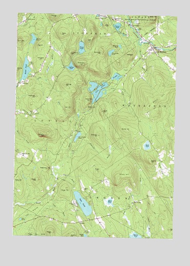
North Waterford, ME USGS Topographic Map
Click on map above to begin viewing in our Map Viewer.

This topographic map contains these locations and features:
Feature Name Type Latitude Longitude GNIS ID View Map
Allen MountainSummitN44.2345°W70.8183°580914View Map
Amos MountainSummitN44.2337°W70.8715°580916View Map
BaldpateSummitN44.2275°W70.7862°580922View Map
Beech HillSummitN44.2013°W70.7656°580930View Map
Black PondLakeN44.1451°W70.7993°580941View Map
Brackett CemeteryCemeteryN44.1563°W70.8055°580948View Map
Bradley PondLakeN44.2353°W70.8620°580952View Map
Burnell HillSummitN44.1854°W70.7872°580961View Map
Clough HillSummitN44.1525°W70.8338°580984View Map
Cold BrookStreamN44.1484°W70.8456°580986View Map
Cushman PondReservoirN44.2203°W70.8320°580998View Map
Cushman Pond DamDamN44.2202°W70.8361°1774527View Map
Dan Charles PondLakeN44.1814°W70.8258°580999View Map
Duck PondLakeN44.1769°W70.7712°581002View Map
Duck Pond BrookStreamN44.1276°W70.7806°581003View Map
East SwedenPopulated PlaceN44.1445°W70.7806°581010View Map
Eastman HillSummitN44.1699°W70.8636°581011View Map
Edgecomb HillSummitN44.1629°W70.8486°581012View Map
Evans HillSummitN44.1618°W70.8095°581017View Map
Five Kezar PondsLakeN44.2074°W70.8110°581024View Map
Flat HillSummitN44.2317°W70.8574°581026View Map
Foster HillSummitN44.1557°W70.8710°581029View Map
Foster HillSummitN44.2391°W70.8404°581030View Map
Green BrookStreamN44.2073°W70.8037°581043View Map
Harding HillSummitN44.2487°W70.8436°581047View Map
Haskell CemeteryCemeteryN44.1423°W70.7823°581049View Map
Heald PondReservoirN44.2181°W70.8674°581058View Map
Heald Pond DamDamN44.2112°W70.8724°1774525View Map
Hillside CemeteryCemeteryN44.2497°W70.8064°581060View Map
Howard MountainSummitN44.1566°W70.8561°581063View Map
Kenniston HillSummitN44.2239°W70.8556°581075View Map
Keyes BrookStreamN44.1590°W70.8417°581076View Map
Keyes PondLakeN44.1435°W70.8202°581077View Map
Kezar FallsFallsN44.1981°W70.8145°581078View Map
Kezar Falls GorgeValleyN44.1949°W70.8203°1908060View Map
Kezar Falls HillSummitN44.2009°W70.8177°581079View Map
Lewis Dana Hill Memorial LibraryBuildingN44.2437°W70.8731°2738513View Map
Lily PondLakeN44.1342°W70.8690°581093View Map
Little Trout BrookStreamN44.2159°W70.8651°581099View Map
Lovell Volunteer Fire Department North StationBuildingN44.2440°W70.8732°2552996View Map
LynchvillePopulated PlaceN44.2442°W70.7845°581108View Map
Marr HillSummitN44.1301°W70.7520°581113View Map
McDaniels HillSummitN44.2032°W70.8594°581117View Map
McDaniels HillSummitN44.2213°W70.8238°581118View Map
Mill BrookStreamN44.2337°W70.7787°581131View Map
Mud PondLakeN44.2418°W70.7804°581141View Map
North WaterfordPopulated PlaceN44.2317°W70.7687°581147View Map
North Waterford Congregational ChurchChurchN44.2306°W70.7703°1908112View Map
North Waterford FairgroundsLocaleN44.2292°W70.7690°1908113View Map
Oak HillSummitN44.1970°W70.8339°581151View Map
Patterson BrookStreamN44.1717°W70.8301°581159View Map
Patterson HillSummitN44.1822°W70.8098°581160View Map
Perry HillSummitN44.1517°W70.8195°581167View Map
Pine HillSummitN44.2440°W70.8058°581174View Map
Popple HillSummitN44.1272°W70.8444°581179View Map
Powers BrookStreamN44.1259°W70.7740°581181View Map
Proctor PondLakeN44.2437°W70.7963°581183View Map
Sabattus MountainSummitN44.1823°W70.8513°581198View Map
Skillings HillSummitN44.2103°W70.8362°581206View Map
Slab CityPopulated PlaceN44.2112°W70.8687°581208View Map
Stearns CemeteryCemeteryN44.2214°W70.8628°581219View Map
Stearns HillSummitN44.1681°W70.7681°581220View Map
Stevens CemeteryCemeteryN44.1398°W70.8259°581222View Map
Stone HillSummitN44.1957°W70.8070°581223View Map
Stoneham Post OfficePost OfficeN44.2490°W70.8050°1908105View Map
SwedenPopulated PlaceN44.1334°W70.8226°581236View Map
Sweden Volunteer Fire DepartmentBuildingN44.1354°W70.8107°2552820View Map
Tapawingo CampLocaleN44.1434°W70.8265°581237View Map
Town of SwedenCivilN44.1261°W70.8136°582759View Map
Trout PondLakeN44.2312°W70.8241°581244View Map
Warren BrookStreamN44.2328°W70.7776°581254View Map
Webber CemeteryCemeteryN44.1279°W70.8177°581256View Map
Weymouth HillSummitN44.2286°W70.8085°581260View Map
Weymouth PondLakeN44.2289°W70.8011°581261View Map
Whitehouse HillSummitN44.2290°W70.8315°581266View Map
Whiting HillSummitN44.2178°W70.8742°581269View Map
Whitney PondLakeN44.2324°W70.7940°581270View Map
Winns HillSummitN44.1587°W70.7923°581276View Map
Woodlawn CemeteryCemeteryN44.2251°W70.7765°581279View Map

Note: Coordinates in the location and feature list above are referenced to NAD83 datum.


Copyright (C) 2008-2024 Ryan Niemi / Sunset Dynamics ... All Rights Reserved