TopoQuest Logo
Do you find TopoQuest useful?
Help keep TopoQuest running and adding new maps/features by donating!
Bitcoin:  19c7KJd3qBynnjoSw5npx9KScwjBe4ifkT
Litecoin:  LXs6TkuXGGXo1vDsWCkWVdjQX94eUKd6ui
Home View Maps Find Maps Find Places Resources & Links


Bristol, Vermont Topographic Map

USGS Map Title: Bristol, VT
USGS Map MRC: 44073B1
DRG (GeoTIFF) Download: o44073b1.tif


Neighboring USGS Topographic Map Quads:


  Mount Philo, VT  
44073C2
 

  Hinesburg, VT  
44073C1
 

  Huntington, VT  
44072C8
 

  Vergennes East, VT  
44073B2
 

  Bristol, VT  
44073B1
 

  Mount Ellen, VT  
44072B8
 

  Middlebury, VT  
44073A2
 

  South Mountain, VT  
44073A1
 

  Lincoln, VT  
44072A8


Map MRC Location:

N45°
W74°
N45°
W73°
H8 H7 H6 H5 H4 H3 H2 H1
G8 G7 G6 G5 G4 G3 G2 G1
F8 F7 F6 F5 F4 F3 F2 F1
E8 E7 E6 E5 E4 E3 E2 E1
D8 D7 D6 D5 D4 D3 D2 D1
C8 C7 C6 C5 C4 C3 C2 C1
B8 B7 B6 B5 B4 B3 B2 B1
A8 A7 A6 A5 A4 A3 A2 A1
N44°
W74°
N44°
W73°

Bristol, VT USGS 1:24K Topographic Map Preview:
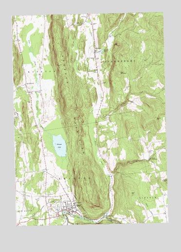
Bristol, VT USGS Topographic Map
Click on map above to begin viewing in our Map Viewer.

This topographic map contains these locations and features:
Feature Name Type Latitude Longitude GNIS ID View Map
Addison Northeast Supervisory UnionSchoolN44.1357°W73.0941°2427417View Map
Bald HillSummitN44.1426°W73.0304°1460545View Map
Baldwin CreekStreamN44.1320°W73.0504°1460551View Map
Baldwin PondLakeN44.2275°W73.0519°1460552View Map
Beaver BrookStreamN44.1520°W73.0471°1460582View Map
Briggs Hill CemeteryCemeteryN44.1279°W73.0380°1460659View Map
BristolPopulated PlaceN44.1334°W73.0790°1460661View Map
Bristol Airport (historical)AirportN44.1351°W73.0937°1461737View Map
Bristol Baptist ChurchChurchN44.1356°W73.0787°1918045View Map
Bristol Census Designated PlaceCensusN44.1383°W73.0874°2378124View Map
Bristol Downtown Historic DistrictParkN44.1334°W73.0785°1918047View Map
Bristol Elementary SchoolSchoolN44.1381°W73.0774°1461186View Map
Bristol Federated ChurchChurchN44.1356°W73.0787°1918048View Map
Bristol Fire StationBuildingN44.1355°W73.0784°2121354View Map
Bristol Police DepartmentBuildingN44.1330°W73.0790°2752795View Map
Bristol PondLakeN44.1724°W73.0880°1461627View Map
Bristol PondReservoirN44.1312°W73.1115°1918050View Map
Bristol Post OfficePost OfficeN44.1331°W73.0797°1918051View Map
Bristol Rescue SquadBuildingN44.1474°W73.0864°2578087View Map
Bristol RockPillarN44.1295°W73.0696°1460663View Map
Bristol Town HallBuildingN44.1323°W73.0782°1918052View Map
Clover Set FarmLocaleN44.1353°W73.1178°2680829View Map
East MonktonPopulated PlaceN44.2089°W73.1146°1460831View Map
East Monkton CemeteryCemeteryN44.2050°W73.1032°1460832View Map
East MountainSummitN44.2145°W73.0371°1460834View Map
Friends CemeteryCemeteryN44.1344°W73.0004°1460888View Map
Friends ChurchChurchN44.1673°W73.0146°1460889View Map
Green Mount CemeteryCemeteryN44.2484°W73.0625°1460932View Map
Greenwood CemeteryCemeteryN44.1309°W73.0940°1460938View Map
Hallock CemeteryCemeteryN44.2225°W73.0167°1460951View Map
High KnobSummitN44.2317°W73.0379°1460989View Map
Hillsboro CemeteryCemeteryN44.2059°W73.0321°1460991View Map
Hogback MountainsRidgeN44.1992°W73.0798°1460995View Map
Horan CemeteryCemeteryN44.2009°W73.1218°1918122View Map
Howden Hall SchoolSchoolN44.1331°W73.0815°1461009View Map
Lincoln LibraryBuildingN44.1353°W73.0782°1918148View Map
Lincoln Municipal ForestForestN44.1389°W73.0260°1918149View Map
Merrill CemeteryCemeteryN44.1418°W73.0036°1461141View Map
Monkton ChurchChurchN44.2045°W73.1098°1461168View Map
Mount Abraham Union High SchoolSchoolN44.1354°W73.0941°1918174View Map
Mount Saint Joseph CemeteryCemeteryN44.1427°W73.0993°1461182View Map
Norton CemeteryCemeteryN44.1971°W73.0273°1460689View Map
Norton HillSummitN44.1864°W73.0082°1461235View Map
Red Cedar SchoolSchoolN44.1577°W73.1042°2427365View Map
Robinson Elementary SchoolSchoolN44.2233°W73.0576°1461344View Map
RockvillePopulated PlaceN44.2456°W73.0643°1461347View Map
Rocky DalePopulated PlaceN44.1292°W73.0490°1461348View Map
Saint Ambrose Parish HallChurchN44.1339°W73.0801°1918222View Map
Smith CemeteryCemeteryN44.1986°W73.1106°1461413View Map
South StarksboroPopulated PlaceN44.1626°W73.0137°1461446View Map
South Starksboro Friends CemeteryCemeteryN44.1673°W73.0143°1918247View Map
StarksboroPopulated PlaceN44.2273°W73.0573°1461467View Map
Starksboro Post OfficePost OfficeN44.2285°W73.0567°1918250View Map
Starksboro Village Meeting HouseChurchN44.2248°W73.0565°1918251View Map
Starksboro Volunteer Fire Department Station 1BuildingN44.2412°W73.0579°2121343View Map
Taft CemeteryCemeteryN44.1981°W73.0515°1918899View Map
Town of StarksboroCivilN44.2287°W73.0156°1462217View Map
Varney CemeteryCemeteryN44.1578°W73.1017°1461561View Map
Village CemeteryCemeteryN44.2234°W73.0564°1461565View Map
Winona Recreation AreaParkN44.1523°W73.0962°1918278View Map

Note: Coordinates in the location and feature list above are referenced to NAD83 datum.


Copyright (C) 2008-2024 Ryan Niemi / Sunset Dynamics ... All Rights Reserved