TopoQuest Logo
Do you find TopoQuest useful?
Help keep TopoQuest running and adding new maps/features by donating!
Bitcoin:  19c7KJd3qBynnjoSw5npx9KScwjBe4ifkT
Litecoin:  LXs6TkuXGGXo1vDsWCkWVdjQX94eUKd6ui
Home View Maps Find Maps Find Places Resources & Links


Bronte, Texas Topographic Map

USGS Map Title: Bronte, TX
USGS Map MRC: 31100H3
DRG (GeoTIFF) Download: o31100h3.tif


Neighboring USGS Topographic Map Quads:


  Blackwell SW, TX  
32100A4
 

  Blackwell, TX  
32100A3
 

  Church Peak, TX  
32100A2
 

  Robert Lee, TX  
31100H4
 

  Bronte, TX  
31100H3
 

  Hog Mountain, TX  
31100H2
 

  Cement Mountain, TX  
31100G4
 

  Shawville, TX  
31100G3
 

  Maverick, TX  
31100G2


Map MRC Location:

N32°
W101°
N32°
W100°
H8 H7 H6 H5 H4 H3 H2 H1
G8 G7 G6 G5 G4 G3 G2 G1
F8 F7 F6 F5 F4 F3 F2 F1
E8 E7 E6 E5 E4 E3 E2 E1
D8 D7 D6 D5 D4 D3 D2 D1
C8 C7 C6 C5 C4 C3 C2 C1
B8 B7 B6 B5 B4 B3 B2 B1
A8 A7 A6 A5 A4 A3 A2 A1
N31°
W101°
N31°
W100°

Bronte, TX USGS 1:24K Topographic Map Preview:
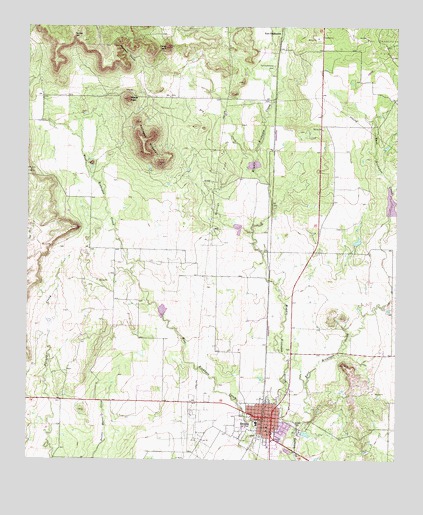
Bronte, TX USGS Topographic Map
Click on map above to begin viewing in our Map Viewer.

This topographic map contains these locations and features:
Feature Name Type Latitude Longitude GNIS ID View Map
BrontePopulated PlaceN31.8874°W100.2918°1372729View Map
Bronte Church of ChristChurchN31.8879°W100.2968°2016625View Map
Bronte City HallBuildingN31.8869°W100.2936°2753372View Map
Bronte DivisionCivilN31.9025°W100.3518°1938567View Map
Bronte Elementary SchoolSchoolN31.8890°W100.2968°2004665View Map
Bronte High SchoolSchoolN31.8890°W100.2968°2004666View Map
Bronte Oil FieldOilfieldN31.8796°W100.3168°1331306View Map
Bronte Post OfficePost OfficeN31.8867°W100.2936°2732035View Map
Bronte Volunteer Fire DepartmentBuildingN31.8774°W100.3005°2552103View Map
Deadman CanyonValleyN31.9870°W100.3373°1334145View Map
Dry CreekStreamN31.9604°W100.2982°1334663View Map
East Coke County Ambulance ServiceBuildingN31.8868°W100.2936°2655881View Map
East Kickapoo CreekStreamN31.8854°W100.2834°1334957View Map
Edward Rawling Lower TankReservoirN31.9118°W100.3679°1861204View Map
Edward Rawling Lower Tank DamDamN31.9118°W100.3670°1861203View Map
Edward Rawling Upper TankReservoirN31.9135°W100.3670°1861206View Map
Edward Rawling Upper Tank DamDamN31.9135°W100.3670°1861205View Map
Fairview CemeteryCemeteryN31.8807°W100.2887°1335624View Map
Fort Chadbourne CemeteryCemeteryN31.9890°W100.2921°1336048View Map
Jones PeakSummitN31.9940°W100.3282°1338863View Map
Kickapoo MountainSummitN31.9671°W100.3365°1339086View Map
Middle Kickapoo CreekStreamN31.8860°W100.2837°1341501View Map
Nipple PeakSummitN31.9790°W100.3415°1342614View Map
Old City LakeReservoirN31.8826°W100.2807°1864255View Map
Old City Lake DamDamN31.8835°W100.2820°1864254View Map
Panther GapGapN31.9979°W100.3598°1343540View Map
Rawlings Oil FieldOilfieldN31.9535°W100.3087°1344840View Map
Soil Conservation Service Site 2 DamDamN31.9235°W100.3337°1861195View Map
Soil Conservation Service Site 2 ReservoirReservoirN31.9235°W100.3337°1861196View Map
Soil Conservation Service Site 3 DamDamN31.9418°W100.3020°1861197View Map
Soil Conservation Service Site 3 ReservoirReservoirN31.9420°W100.3042°1861198View Map
Soil Conservation Service Site 5 DamDamN31.9585°W100.2987°1861199View Map
Soil Conservation Service Site 5 ReservoirReservoirN31.9605°W100.2987°1861200View Map
Soil Conservation Service Site 6 DamDamN31.9418°W100.2537°1861201View Map
Soil Conservation Service Site 6 ReservoirReservoirN31.9494°W100.2523°1861202View Map
Town of BronteCivilN31.8857°W100.2954°2411732View Map

Note: Coordinates in the location and feature list above are referenced to NAD83 datum.


Copyright (C) 2008-2024 Ryan Niemi / Sunset Dynamics ... All Rights Reserved