TopoQuest Logo
Do you find TopoQuest useful?
Help keep TopoQuest running and adding new maps/features by donating!
Bitcoin:  19c7KJd3qBynnjoSw5npx9KScwjBe4ifkT
Litecoin:  LXs6TkuXGGXo1vDsWCkWVdjQX94eUKd6ui
Home View Maps Find Maps Find Places Resources & Links


Browns Canyon, Montana Topographic Map

USGS Map Title: Browns Canyon, MT
USGS Map MRC: 46110G2
DRG (GeoTIFF) Download: o46110g2.tif


Neighboring USGS Topographic Map Quads:


  Woodhurst Mountain, MT  
46110H3
 

  Red Hill, MT  
46110H2
 

  Utica, MT  
46110H1
 

  Indian Hill, MT  
46110G3
 

  Browns Canyon, MT  
46110G2
 

  Twin Sisters, MT  
46110G1
 

  Daisy Peak, MT  
46110F3
 

  Haymaker Narrows, MT  
46110F2
 

  Jellison Place, MT  
46110F1


Map MRC Location:

N47°
W111°
N47°
W110°
H8 H7 H6 H5 H4 H3 H2 H1
G8 G7 G6 G5 G4 G3 G2 G1
F8 F7 F6 F5 F4 F3 F2 F1
E8 E7 E6 E5 E4 E3 E2 E1
D8 D7 D6 D5 D4 D3 D2 D1
C8 C7 C6 C5 C4 C3 C2 C1
B8 B7 B6 B5 B4 B3 B2 B1
A8 A7 A6 A5 A4 A3 A2 A1
N46°
W111°
N46°
W110°

Browns Canyon, MT USGS 1:24K Topographic Map Preview:
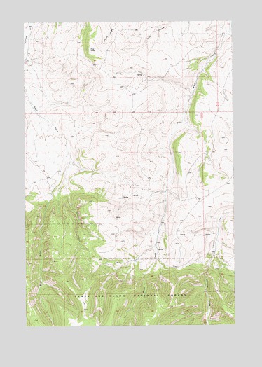
Browns Canyon, MT USGS Topographic Map
Click on map above to begin viewing in our Map Viewer.

This topographic map contains these locations and features:
Feature Name Type Latitude Longitude GNIS ID View Map
12N12E01BD__01 SpringSpringN46.8297°W110.1571°818643View Map
12N12E02DA__01 SpringSpringN46.8261°W110.1677°818629View Map
12N12E02DD__01 SpringSpringN46.8225°W110.1677°818587View Map
12N12E02DD__02 SpringSpringN46.8225°W110.1677°818588View Map
12N12E03AA__01 SpringSpringN46.8333°W110.1888°818671View Map
12N12E03AC__01 SpringSpringN46.8297°W110.1941°818644View Map
12N12E03BB__01 SpringSpringN46.8333°W110.2046°818672View Map
12N12E03BC__01 SpringSpringN46.8297°W110.2046°818645View Map
12N12E05AD__01 SpringSpringN46.8297°W110.2308°818646View Map
12N12E08DC__01 WellWellN46.8077°W110.2360°818436View Map
12N12E08DC__02 WellWellN46.8077°W110.2360°818437View Map
12N12E09CC__01 SpringSpringN46.8077°W110.2255°818435View Map
12N12E09CD__01 SpringSpringN46.8077°W110.2202°818434View Map
12N12E09DB__01 SpringSpringN46.8113°W110.2149°818463View Map
12N12E10AD__01 SpringSpringN46.8150°W110.1888°818492View Map
12N12E10BD__01 SpringSpringN46.8155°W110.1994°818497View Map
12N12E11AD__01 SpringSpringN46.8150°W110.1677°818491View Map
12N12E11BB__01 SpringSpringN46.8186°W110.1835°818539View Map
12N12E12BB__01 SpringSpringN46.8186°W110.1624°818538View Map
12N12E12BC__01 SpringSpringN46.8150°W110.1624°818490View Map
12N12E12CC__01 SpringSpringN46.8077°W110.1624°818433View Map
12N12E13AA__01 SpringSpringN46.8038°W110.1466°818410View Map
12N12E13DD__01 SpringSpringN46.7930°W110.1466°818356View Map
12N12E14DC__01 SpringSpringN46.7930°W110.1730°818357View Map
12N12E15AD__01 SpringSpringN46.8002°W110.1888°818393View Map
12N12E15CD__01 SpringSpringN46.7930°W110.1994°818358View Map
12N12E23AA__01 SpringSpringN46.7891°W110.1677°818339View Map
12N12E23BB__01 SpringSpringN46.7891°W110.1835°818340View Map
12N12E23BC__01 SpringSpringN46.7855°W110.1835°818299View Map
12N12E23DB__01 SpringSpringN46.7819°W110.1730°818273View Map
12N12E24AA__01 SpringSpringN46.7891°W110.1466°818338View Map
12N12E24BD__01 SpringSpringN46.7855°W110.1571°818298View Map
12N12E24CA__01 SpringSpringN46.7819°W110.1571°818271View Map
12N12E24CB__01 SpringSpringN46.7819°W110.1624°818272View Map
12N12E24DB__01 SpringSpringN46.7827°W110.1516°818276View Map
12N12E25AA__01 SpringSpringN46.7758°W110.1460°818231View Map
12N13E06BC__01 SpringSpringN46.8288°W110.1410°818640View Map
12N13E06CB__01 SpringSpringN46.8252°W110.1410°818625View Map
12N13E07AA__01 SpringSpringN46.8177°W110.1252°818523View Map
12N13E18DA__01 SpringSpringN46.7961°W110.1252°818372View Map
12N13E19BC__01 SpringSpringN46.7850°W110.1410°818292View Map
13N12E19AC__01 WellWellN46.8741°W110.2466°819000View Map
13N12E20CCDC01 WellWellN46.8669°W110.2360°818942View Map
13N12E20DD__01 SpringSpringN46.8669°W110.2202°818941View Map
13N12E23DB__01 WellWellN46.8705°W110.1619°818970View Map
13N12E27DD__01 SpringSpringN46.8529°W110.1797°818804View Map
13N12E32AD__01 SpringSpringN46.8452°W110.2202°818733View Map
13N12E34AA__01 SpringSpringN46.8488°W110.1777°818759View Map
13N12E34AC__01 SpringSpringN46.8452°W110.1830°818732View Map
13N12E35AA__01 SpringSpringN46.8488°W110.1566°818757View Map
13N12E35BB__01 SpringSpringN46.8488°W110.1724°818758View Map
13N12E35DD__01 SpringSpringN46.8380°W110.1566°818697View Map
13N12E36BC__01 SpringSpringN46.8452°W110.1513°818731View Map
Antelope GorgeValleyN46.7797°W110.1374°779075View Map
Browns CanyonValleyN46.8211°W110.2233°780452View Map
Pine KnobSummitN46.8633°W110.2102°788898View Map

Note: Coordinates in the location and feature list above are referenced to NAD83 datum.


Copyright (C) 2008-2025 Ryan Niemi / Sunset Dynamics ... All Rights Reserved