TopoQuest Logo
Do you find TopoQuest useful?
Help keep TopoQuest running and adding new maps/features by donating!
Bitcoin:  19c7KJd3qBynnjoSw5npx9KScwjBe4ifkT
Litecoin:  LXs6TkuXGGXo1vDsWCkWVdjQX94eUKd6ui
Home View Maps Find Maps Find Places Resources & Links


Buckeye, Arizona Topographic Map

USGS Map Title: Buckeye, AZ
USGS Map MRC: 33112C5
DRG (GeoTIFF) Download: o33112c5.tif


Neighboring USGS Topographic Map Quads:


  Buckeye NW, AZ  
33112D6
 

  Valencia, AZ  
33112D5
 

  Perryville, AZ  
33112D4
 

  Hassayampa, AZ  
33112C6
 

  Buckeye, AZ  
33112C5
 

  Avondale SW, AZ  
33112C4
 

  Cotton Center NW, AZ  
33112B6
 

  Margies Peak, AZ  
33112B5
 

  Mobile NW, AZ  
33112B4


Map MRC Location:

N34°
W113°
N34°
W112°
H8 H7 H6 H5 H4 H3 H2 H1
G8 G7 G6 G5 G4 G3 G2 G1
F8 F7 F6 F5 F4 F3 F2 F1
E8 E7 E6 E5 E4 E3 E2 E1
D8 D7 D6 D5 D4 D3 D2 D1
C8 C7 C6 C5 C4 C3 C2 C1
B8 B7 B6 B5 B4 B3 B2 B1
A8 A7 A6 A5 A4 A3 A2 A1
N33°
W113°
N33°
W112°

Buckeye, AZ USGS 1:24K Topographic Map Preview:
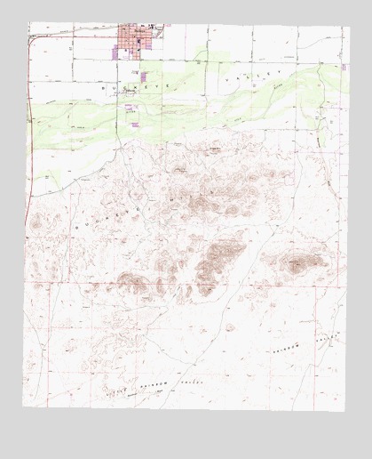
Buckeye, AZ USGS Topographic Map
Click on map above to begin viewing in our Map Viewer.

This topographic map contains these locations and features:
Feature Name Type Latitude Longitude GNIS ID View Map
AllenvillePopulated PlaceN33.3520°W112.5866°605View Map
BuckeyePopulated PlaceN33.3703°W112.5838°2081View Map
Buckeye AcademySchoolN33.3743°W112.5861°2517835View Map
Buckeye City HallBuildingN33.3709°W112.5841°14244View Map
Buckeye Elementary SchoolSchoolN33.3692°W112.5825°14246View Map
Buckeye Fire Department Station 701 DowntownBuildingN33.3665°W112.5904°2672430View Map
Buckeye Light and Life ChurchChurchN33.3721°W112.5877°2670652View Map
Buckeye Middle SchoolSchoolN33.3690°W112.5829°2466651View Map
Buckeye Police DepartmentBuildingN33.3723°W112.5725°2672253View Map
Buckeye Post OfficePost OfficeN33.3699°W112.5913°44824View Map
Buckeye Primary SchoolSchoolN33.3684°W112.5825°2466652View Map
Buckeye Public LibraryBuildingN33.3728°W112.5832°14252View Map
Buckeye Seventh Day Adventist ChurchChurchN33.3743°W112.5876°2670653View Map
Buckeye Sports FieldParkN33.3650°W112.5882°14253View Map
Buckeye Town ParkParkN33.3720°W112.5766°14255View Map
Buckeye Valley Fire District Station 324BuildingN33.3712°W112.5930°2672406View Map
Buckeye Valley MuseumBuildingN33.3713°W112.5759°2669495View Map
Cactus Plaza Shopping CenterLocaleN33.3728°W112.5829°14263View Map
Community United Methodist ChurchChurchN33.3734°W112.5790°2670805View Map
Dr Robert A Saide Recreation CenterBuildingN33.3728°W112.5758°2670019View Map
Eagle MountainSummitN33.3339°W112.5524°4237View Map
Estrella Valley Mobile Home ParkPopulated PlaceN33.3684°W112.5761°2670275View Map
Farm Ag AirportAirportN33.3677°W112.6241°45309View Map
First Southern Baptist Church in BuckeyeChurchN33.3731°W112.5884°2671009View Map
Maricopa County Sheriff's Office BuckeyeBuildingN33.3723°W112.5727°2751596View Map
Mount Pleasant ChurchChurchN33.3654°W112.5846°2671244View Map
Rainbow ValleyValleyN33.2834°W112.5424°9925View Map
The Church of Jesus Christ of Latter Day SaintsChurchN33.3736°W112.5759°2671342View Map
Town of Buckeye Wastewater Treatment PlantLocaleN33.3593°W112.5828°2467045View Map
Waterman WashStreamN33.3489°W112.5318°13401View Map
Westpark Elementary SchoolSchoolN33.3691°W112.5834°2467347View Map

Note: Coordinates in the location and feature list above are referenced to NAD83 datum.


Copyright (C) 2008-2025 Ryan Niemi / Sunset Dynamics ... All Rights Reserved