TopoQuest Logo
Do you find TopoQuest useful?
Help keep TopoQuest running and adding new maps/features by donating!
Bitcoin:  19c7KJd3qBynnjoSw5npx9KScwjBe4ifkT
Litecoin:  LXs6TkuXGGXo1vDsWCkWVdjQX94eUKd6ui
Home View Maps Find Maps Find Places Resources & Links


Buckeye Lake, Oregon Topographic Map

USGS Map Title: Buckeye Lake, OR
USGS Map MRC: 43122A5
DRG (GeoTIFF) Download: o43122a5.tif


Neighboring USGS Topographic Map Quads:


  Quartz Mountain, OR  
43122B6
 

  Twin Lakes Mountain, OR  
43122B5
 

  Fish Creek Desert, OR  
43122B4
 

  Acker Rock, OR  
43122A6
 

  Buckeye Lake, OR  
43122A5
 

  Fish Mountain, OR  
43122A4
 

  Butler Butte, OR  
42122H6
 

  Abbott Butte, OR  
42122H5
 

  Union Creek, OR  
42122H4


Map MRC Location:

N44°
W123°
N44°
W122°
H8 H7 H6 H5 H4 H3 H2 H1
G8 G7 G6 G5 G4 G3 G2 G1
F8 F7 F6 F5 F4 F3 F2 F1
E8 E7 E6 E5 E4 E3 E2 E1
D8 D7 D6 D5 D4 D3 D2 D1
C8 C7 C6 C5 C4 C3 C2 C1
B8 B7 B6 B5 B4 B3 B2 B1
A8 A7 A6 A5 A4 A3 A2 A1
N43°
W123°
N43°
W122°

Buckeye Lake, OR USGS 1:24K Topographic Map Preview:
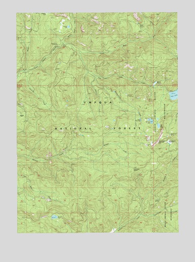
Buckeye Lake, OR USGS Topographic Map
Click on map above to begin viewing in our Map Viewer.

This topographic map contains these locations and features:
Feature Name Type Latitude Longitude GNIS ID View Map
Acker Divide TrailTrailN43.0201°W122.5748°1137005View Map
Beaver SwampSwampN43.0845°W122.5189°1137851View Map
Beaver Swamp Recreation SiteLocaleN43.0937°W122.5184°1167670View Map
Beaver Swamp TrailheadLocaleN43.0932°W122.5178°1156362View Map
Black Rock ForkStreamN43.1071°W122.5889°1138219View Map
Buckeye LakeLakeN43.0631°W122.5218°1138847View Map
Buckeye Lake CampgroundLocaleN43.0651°W122.5234°1155277View Map
Buster SpringSpringN43.1167°W122.5304°1155282View Map
Buster Spring ShelterLocaleN43.1140°W122.5278°1139030View Map
Camp Comfort Recreation SiteLocaleN43.1060°W122.5937°1162588View Map
Carmen LakeLakeN43.1168°W122.5857°1163938View Map
Castle Rock ForkStreamN43.1071°W122.5889°1139448View Map
Castor LakeLakeN43.1040°W122.5706°1155280View Map
Cliff LakeLakeN43.0604°W122.5163°1139828View Map
Cliff Lake CampgroundLocaleN43.0179°W122.5609°1155278View Map
Emerson CreekStreamN43.0912°W122.6192°1141848View Map
Emerson RanchLocaleN43.0665°W122.6228°1141849View Map
Fish LakeLakeN43.0781°W122.5029°1142163View Map
Fish Lake CreekStreamN43.1026°W122.5770°1142164View Map
Fish Lake Recreation SiteLocaleN43.0879°W122.5595°1167669View Map
Fish Lake TrailheadLocaleN43.0879°W122.5589°1156382View Map
Grasshopper MeadowFlatN43.0513°W122.5080°1163940View Map
Grasshopper MountainSummitN43.0512°W122.5168°1142962View Map
Grasshopper SpringSpringN43.0556°W122.5074°1163939View Map
Jackson Creek TrailTrailN43.0235°W122.5084°1144205View Map
Jade CampLocaleN43.0446°W122.5903°1144211View Map
Little Fish LakeLakeN43.0638°W122.5302°1145168View Map
Lonewoman CreekStreamN43.0093°W122.5306°1145381View Map
Mink CreekStreamN43.1246°W122.5823°1146328View Map
Mosquito CampLocaleN43.0512°W122.5262°1155276View Map
Sadie SpringSpringN43.0186°W122.5164°1148919View Map
Silver CreekStreamN43.1054°W122.5956°1155281View Map
Skillet CreekStreamN43.0918°W122.6198°1149591View Map
Skimmerhorn CreekStreamN43.0887°W122.5650°1149592View Map
Skimmerhorn Recreation SiteLocaleN43.0776°W122.5400°1167668View Map
Skimmerhorn TrailheadLocaleN43.0779°W122.5395°1156383View Map
Skookum PondLakeN43.0089°W122.5973°1163941View Map
South Umpqua Falls Recreation SiteLocaleN43.0540°W122.5198°1155296View Map
West Fork Skimmerhorn CreekStreamN43.0868°W122.5648°1152114View Map

Note: Coordinates in the location and feature list above are referenced to NAD83 datum.


Copyright (C) 2008-2024 Ryan Niemi / Sunset Dynamics ... All Rights Reserved