TopoQuest Logo
Do you find TopoQuest useful?
Help keep TopoQuest running and adding new maps/features by donating!
Bitcoin:  19c7KJd3qBynnjoSw5npx9KScwjBe4ifkT
Litecoin:  LXs6TkuXGGXo1vDsWCkWVdjQX94eUKd6ui
Home View Maps Find Maps Find Places Resources & Links


Buffalo, Montana Topographic Map

USGS Map Title: Buffalo, MT
USGS Map MRC: 46109G7
DRG (GeoTIFF) Download: o46109g7.tif


Neighboring USGS Topographic Map Quads:


  Ackley Lake, MT  
46109H8
 

  Sipple, MT  
46109H7
 

  Moore, MT  
46109H6
 

  Martin Coulee, MT  
46109G8
 

  Buffalo, MT  
46109G7
 

  Moore SW, MT  
46109G6
 

  Mead Creek, MT  
46109F8
 

  Judith Gap, MT  
46109F7
 

  Elephant Rocks, MT  
46109F6


Map MRC Location:

N47°
W110°
N47°
W109°
H8 H7 H6 H5 H4 H3 H2 H1
G8 G7 G6 G5 G4 G3 G2 G1
F8 F7 F6 F5 F4 F3 F2 F1
E8 E7 E6 E5 E4 E3 E2 E1
D8 D7 D6 D5 D4 D3 D2 D1
C8 C7 C6 C5 C4 C3 C2 C1
B8 B7 B6 B5 B4 B3 B2 B1
A8 A7 A6 A5 A4 A3 A2 A1
N46°
W110°
N46°
W109°

Buffalo, MT USGS 1:24K Topographic Map Preview:
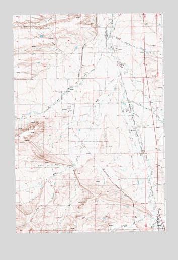
Buffalo, MT USGS Topographic Map
Click on map above to begin viewing in our Map Viewer.

This topographic map contains these locations and features:
Feature Name Type Latitude Longitude GNIS ID View Map
11N15E05AA__01 SpringSpringN46.7502°W109.8513°818076View Map
11N16E06BB__01 WellWellN46.7516°W109.7641°818090View Map
11N16E06BB__02 WellWellN46.7516°W109.7641°818091View Map
12N15E01BC__01 WellWellN46.8325°W109.7844°818665View Map
12N15E01BC__02 WellWellN46.8325°W109.7844°818666View Map
12N15E04CD__01 WellWellN46.8252°W109.8416°818618View Map
12N15E04CD__02 WellWellN46.8252°W109.8416°818619View Map
12N15E04DC__01 WellWellN46.8252°W109.8363°818617View Map
12N15E04DD__01 WellWellN46.8252°W109.8310°818612View Map
12N15E04DD__02 WellWellN46.8252°W109.8310°818613View Map
12N15E04DD__03 WellWellN46.8252°W109.8310°818614View Map
12N15E04DD__04 WellWellN46.8252°W109.8310°818615View Map
12N15E04DD__05 WellWellN46.8252°W109.8310°818616View Map
12N15E05CD__01 WellWellN46.8252°W109.8624°818620View Map
12N15E08AA__01 WellWellN46.8216°W109.8519°818577View Map
12N15E08AA__02 WellWellN46.8216°W109.8519°818578View Map
12N15E08AD__01 WellWellN46.8180°W109.8519°818532View Map
12N15E08AD__02 WellWellN46.8180°W109.8519°818533View Map
12N15E09AA__01 WellWellN46.8216°W109.8310°818575View Map
12N15E09AA__02 WellWellN46.8216°W109.8310°818576View Map
12N15E10AA__01 WellWellN46.8216°W109.8102°818569View Map
12N15E10AA__02 WellWellN46.8216°W109.8102°818570View Map
12N15E10AA__03 WellWellN46.8216°W109.8102°818571View Map
12N15E10BB__01 WellWellN46.8216°W109.8260°818572View Map
12N15E10BB__02 WellWellN46.8216°W109.8260°818573View Map
12N15E10BB__03 WellWellN46.8216°W109.8260°818574View Map
12N15E10BC__01 WellWellN46.8180°W109.8260°818530View Map
12N15E10BC__02 WellWellN46.8180°W109.8260°818531View Map
12N15E11AA__01 WellWellN46.8216°W109.7894°818567View Map
12N15E11AA__02 WellWellN46.8216°W109.7894°818568View Map
12N15E12DD__01 WellWellN46.8108°W109.7685°818456View Map
12N15E12DD__02 WellWellN46.8108°W109.7685°818457View Map
12N15E13BB__01 WellWellN46.8072°W109.7844°818424View Map
12N15E20AC__01 SpringSpringN46.7888°W109.8571°818330View Map
12N15E20BC__01 WellWellN46.7888°W109.8677°818331View Map
12N15E20BC__02 WellWellN46.7888°W109.8677°818332View Map
12N15E20BC__03 SpringSpringN46.7888°W109.8677°818333View Map
12N15E21AC__01 WellWellN46.7888°W109.8363°818328View Map
12N15E21AC__02 WellWellN46.7888°W109.8363°818329View Map
12N15E22BC__01 WellWellN46.7888°W109.8260°818326View Map
12N15E22BC__02 WellWellN46.7888°W109.8260°818327View Map
12N15E22BCDC01 WellWellN46.7877°W109.8266°818308View Map
12N15E22BD__02 WellWellN46.7888°W109.8207°818324View Map
12N15E22BD__03 WellWellN46.7888°W109.8207°818325View Map
12N15E22CB__01 WellWellN46.7852°W109.8260°818295View Map
12N15E25AA__01 WellWellN46.7780°W109.7685°818246View Map
12N15E28DA__01 WellWellN46.7708°W109.8310°818198View Map
12N15E29AA__01 WellWellN46.7780°W109.8519°818247View Map
12N15E29AD__01 SpringSpringN46.7744°W109.8519°818220View Map
12N15E29DD__01 WellWellN46.7672°W109.8519°818172View Map
12N15E33AA__01 WellWellN46.7636°W109.8310°818149View Map
12N15E33AA__02 WellWellN46.7636°W109.8310°818150View Map
12N15E33BB__01 WellWellN46.7636°W109.8469°818151View Map
12N15E34AA__01 WellWellN46.7636°W109.8102°818148View Map
12N15E34BD__01 WellWellN46.7600°W109.8207°818134View Map
12N15E35DC__01 WellWellN46.7527°W109.7946°818098View Map
12N16E07BB__01 WellWellN46.8219°W109.7635°818583View Map
12N16E19CD__01 WellWellN46.7819°W109.7582°818269View Map
12N16E19CD__02 WellWellN46.7819°W109.7582°818270View Map
12N16E30AB__01 WellWellN46.7783°W109.7530°818249View Map
12N16E30BB__01 WellWellN46.7783°W109.7635°818250View Map
12N16E30BB__02 WellWellN46.7783°W109.7635°818251View Map
12N16E30BB__03 WellWellN46.7783°W109.7635°818252View Map
12N16E30DCC_01 WellWellN46.7658°W109.7560°818159View Map
12N16E31AC__01 WellWellN46.7602°W109.7530°818136View Map
12N16E31CC__01 WellWellN46.7530°W109.7635°818103View Map
12N16E31CC__02 WellWellN46.7530°W109.7635°818104View Map
12N16E31CD__01 WellWellN46.7530°W109.7582°818102View Map
12N16E31DC__01 WellWellN46.7530°W109.7530°818101View Map
13N15E22DC__01 SpringSpringN46.8700°W109.8030°818968View Map
13N15E23CC__01 WellWellN46.8700°W109.7924°818967View Map
13N15E23DB__01 WellWellN46.8736°W109.7819°818996View Map
13N15E25CC__01 WellWellN46.8555°W109.7713°818827View Map
13N15E26AB__01 WellWellN46.8663°W109.7819°818940View Map
13N15E26CC__01 WellWellN46.8555°W109.7924°818833View Map
13N15E26CD__01 WellWellN46.8555°W109.7871°818828View Map
13N15E26CD__02 WellWellN46.8555°W109.7871°818829View Map
13N15E26CD__03 WellWellN46.8555°W109.7871°818830View Map
13N15E26CD__04 WellWellN46.8555°W109.7871°818831View Map
13N15E26CD__05 WellWellN46.8555°W109.7871°818832View Map
13N15E31BD__01 SpringSpringN46.8483°W109.8713°818753View Map
13N15E32AD__01 WellWellN46.8483°W109.8396°818752View Map
13N15E34AA__01 WellWellN46.8519°W109.7977°818798View Map
13N15E34AA__02 WellWellN46.8519°W109.7977°818799View Map
13N15E34AA__03 WellWellN46.8519°W109.7977°818800View Map
13N15E35BB__01 WellWellN46.8519°W109.7924°818796View Map
13N15E35BB__02 WellWellN46.8519°W109.7924°818797View Map
13N15E36BB__01 WellWellN46.8519°W109.7713°818794View Map
13N15E36BB__02 WellWellN46.8519°W109.7713°818795View Map
Barrows (historical)LocaleN46.7583°W109.7766°1750757View Map
Barrows CreekStreamN46.7583°W109.7616°779386View Map
BuffaloPopulated PlaceN46.8211°W109.8285°769334View Map
BuffaloLocaleN46.8200°W109.8252°1722821View Map
Buffalo CemeteryCemeteryN46.8522°W109.8244°1750723View Map
Buffalo Community ChurchChurchN46.8191°W109.8296°1722550View Map
Buffalo CreekStreamN46.8616°W109.7941°782787View Map
Buffalo Post OfficePost OfficeN46.8223°W109.8281°1722822View Map
Buffalo School (historical)SchoolN46.8208°W109.8313°1722826View Map
Bye-Bye DamDamN46.8616°W109.8507°798514View Map
Dry CreekStreamN46.8277°W109.7832°782580View Map
East Fork Mud CreekStreamN46.7827°W109.8421°782880View Map
Farmers Elevator (historical)LocaleN46.8200°W109.8252°1722824View Map
GarneillPopulated PlaceN46.7525°W109.7527°802105View Map
Garneill (historical)LocaleN46.7525°W109.7527°1722846View Map
Garneill CemeteryCemeteryN46.7513°W109.7513°1722571View Map
Garneill ElevatorLocaleN46.7513°W109.7513°1722570View Map
Garneill Post Office (historical)Post OfficeN46.7525°W109.7527°1722847View Map
McCall-Webster Elevator (historical)LocaleN46.8200°W109.8252°1722823View Map
McClavePopulated PlaceN46.8086°W109.7741°773952View Map
Meadow CreekStreamN46.7583°W109.7619°787146View Map
Monk CouleeValleyN46.7583°W109.7624°798864View Map
Montana Elevator (historical)LocaleN46.8200°W109.8252°1722825View Map
Mud CreekStreamN46.8422°W109.7852°787783View Map
Red Bluff CreekStreamN46.7541°W109.7588°789437View Map
Rocky (historical)LocaleN46.8569°W109.8160°1750732View Map
StrawPopulated PlaceN46.8541°W109.7896°794934View Map
Straw (historical)LocaleN46.8541°W109.7896°1722944View Map
Straw Post Office (historical)Post OfficeN46.8541°W109.7896°1722943View Map
West Buffalo CreekStreamN46.8577°W109.7966°792959View Map
West Fork Mud CreekStreamN46.7880°W109.8305°793051View Map

Note: Coordinates in the location and feature list above are referenced to NAD83 datum.


Copyright (C) 2008-2024 Ryan Niemi / Sunset Dynamics ... All Rights Reserved