TopoQuest Logo
Do you find TopoQuest useful?
Help keep TopoQuest running and adding new maps/features by donating!
Bitcoin:  19c7KJd3qBynnjoSw5npx9KScwjBe4ifkT
Litecoin:  LXs6TkuXGGXo1vDsWCkWVdjQX94eUKd6ui
Home View Maps Find Maps Find Places Resources & Links


Moore, Montana Topographic Map

USGS Map Title: Moore, MT
USGS Map MRC: 46109H6
DRG (GeoTIFF) Download: o46109h6.tif


Neighboring USGS Topographic Map Quads:


  Kolin, MT  
47109A7
 

  Ross Fork, MT  
47109A6
 

  Glengarry, MT  
47109A5
 

  Sipple, MT  
46109H7
 

  Moore, MT  
46109H6
 

  West Fork Beaver Creek, MT  
46109H5
 

  Buffalo, MT  
46109G7
 

  Moore SW, MT  
46109G6
 

  Crystal Lake, MT  
46109G5


Map MRC Location:

N47°
W110°
N47°
W109°
H8 H7 H6 H5 H4 H3 H2 H1
G8 G7 G6 G5 G4 G3 G2 G1
F8 F7 F6 F5 F4 F3 F2 F1
E8 E7 E6 E5 E4 E3 E2 E1
D8 D7 D6 D5 D4 D3 D2 D1
C8 C7 C6 C5 C4 C3 C2 C1
B8 B7 B6 B5 B4 B3 B2 B1
A8 A7 A6 A5 A4 A3 A2 A1
N46°
W110°
N46°
W109°

Moore, MT USGS 1:24K Topographic Map Preview:
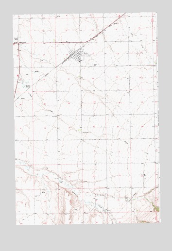
Moore, MT USGS Topographic Map
Click on map above to begin viewing in our Map Viewer.

This topographic map contains these locations and features:
Feature Name Type Latitude Longitude GNIS ID View Map
13N16E01BA__01 WellWellN46.9241°W109.6410°819415View Map
13N16E02BC__01 WellWellN46.9205°W109.6674°819389View Map
13N16E04AA__01 WellWellN46.9241°W109.6941°819416View Map
13N16E07AA__01 WellWellN46.9097°W109.7363°819325View Map
13N16E08AA__01 WellWellN46.9097°W109.7152°819324View Map
13N16E11CB__01 WellWellN46.9025°W109.6674°819279View Map
13N16E11CB__02 WellWellN46.9025°W109.6674°819280View Map
13N16E12AB__01 WellWellN46.9097°W109.6357°819323View Map
13N16E12BD__01 WellWellN46.9061°W109.6410°819312View Map
13N16E13BCBC01 WellWellN46.8914°W109.6491°819179View Map
13N16E15AA__01 WellWellN46.8952°W109.6727°819226View Map
13N16E15CA__01 WellWellN46.8880°W109.6832°819141View Map
13N16E15DD__01 WellWellN46.8844°W109.6727°819092View Map
13N16E17AA__01 WellWellN46.8952°W109.7152°819227View Map
13N16E18DD__01 WellWellN46.8844°W109.7363°819093View Map
13N16E20AB__01 WellWellN46.8805°W109.7205°819042View Map
13N16E20BB__01 WellWellN46.8805°W109.7310°819043View Map
13N16E23BB__01 WellWellN46.8805°W109.6674°819041View Map
13N17E06BB__01 WellWellN46.9236°W109.6255°819409View Map
13N17E18BB__01 WellWellN46.8947°W109.6255°819223View Map
14N16E09DD__01 WellWellN46.9844°W109.6938°819936View Map
14N16E11DD__01 WellWellN46.9844°W109.6507°819935View Map
14N16E13DC__01 WellWellN46.9700°W109.6346°819831View Map
14N16E13DD__01 WellWellN46.9700°W109.6294°819830View Map
14N16E14DD__01 WellWellN46.9700°W109.6507°819832View Map
14N16E15AB__01 WellWellN46.9808°W109.6777°819910View Map
14N16E15AB__02 WellWellN46.9808°W109.6777°819911View Map
14N16E15BB__01 WellWellN46.9808°W109.6882°819912View Map
14N16E15BBCB01 WellWellN46.9811°W109.6882°819917View Map
14N16E15BBCB02 WellWellN46.9811°W109.6882°819918View Map
14N16E15CB__01 WellWellN46.9736°W109.6882°819854View Map
14N16E15DC__01 WellWellN46.9700°W109.6777°819833View Map
14N16E18ABBC01 WellWellN46.9819°W109.7444°819923View Map
14N16E19AC__01 WellWellN46.9630°W109.7419°819748View Map
14N16E19DB__01 WellWellN46.9594°W109.7419°819700View Map
14N16E21AD__01 WellWellN46.9630°W109.6938°819747View Map
14N16E22BA__01 WellWellN46.9666°W109.6830°819802View Map
14N16E23BA__01 WellWellN46.9666°W109.6616°819801View Map
14N16E24CB__01 WellWellN46.9594°W109.6455°819699View Map
14N16E25DC__01 WellWellN46.9414°W109.6346°819527View Map
14N16E26AA__01 WellWellN46.9522°W109.6507°819610View Map
14N16E27BB__01 WellWellN46.9522°W109.6882°819611View Map
14N16E28DA__01 WellWellN46.9450°W109.6938°819549View Map
14N16E28DA__02 WellWellN46.9450°W109.6938°819550View Map
14N16E32BB__01 WellWellN46.9377°W109.7313°819499View Map
14N16E32CD__01 WellWellN46.9269°W109.7257°819433View Map
14N16E32DA__01 WellWellN46.9305°W109.7152°819449View Map
14N16E33DA__01 WellWellN46.9305°W109.6938°819448View Map
14N16E34DD__01 WellWellN46.9269°W109.6721°819432View Map
14N16E35BA__01 WellWellN46.9377°W109.6616°819497View Map
14N16E35BA__02 WellWellN46.9377°W109.6616°819498View Map
14N16E36CC__01 WellWellN46.9269°W109.6455°819431View Map
Community Methodist ChurchChurchN46.9736°W109.6952°1722545View Map
Dawkins SpringsSpringN46.9572°W109.7396°770484View Map
Eddies CornerPopulated PlaceN46.9833°W109.7455°771133View Map
Eddies Corner Incorporated CampgroundLocaleN46.9827°W109.7446°1722507View Map
Meisser School (historical)SchoolN46.9980°W109.7257°1722651View Map
MooreLocaleN46.9755°W109.6969°1722926View Map
MoorePopulated PlaceN46.9755°W109.6969°774361View Map
Moore CemeteryCemeteryN46.9694°W109.6810°774362View Map
Moore City ParkParkN46.9783°W109.6924°1722546View Map
Moore Fire DepartmentBuildingN46.9752°W109.6971°1722543View Map
Moore Hospital (historical)HospitalN46.9755°W109.6969°1722569View Map
Moore Memorial LibraryBuildingN46.9730°W109.6949°1722501View Map
Moore Post OfficePost OfficeN46.9750°W109.6968°1722927View Map
Moore Public SchoolsSchoolN46.9716°W109.6930°1722591View Map
Moore Rural Fire DistrictBuildingN46.9743°W109.6955°1722579View Map
Peavey Company ElevatorLocaleN46.9761°W109.6980°1722544View Map
Pleasant View School (historical)SchoolN46.9402°W109.6924°1722650View Map
Rock Creek School (historical)SchoolN46.9758°W109.6382°1722648View Map
Saint Mathias ChurchChurchN46.9775°W109.6930°1722547View Map
Seright (historical)Populated PlaceN46.9680°W109.6402°1722949View Map
Seright School (historical)SchoolN46.9677°W109.6407°1722649View Map
Town of MooreCivilN46.9750°W109.6951°2413011View Map
Trout Creek Post Office (historical)Post OfficeN46.8875°W109.6802°1722940View Map
Trout Creek School (historical)SchoolN46.8958°W109.6857°1722625View Map
Wright School (historical)SchoolN46.8819°W109.7341°1722626View Map

Note: Coordinates in the location and feature list above are referenced to NAD83 datum.


Copyright (C) 2008-2025 Ryan Niemi / Sunset Dynamics ... All Rights Reserved