TopoQuest Logo
Do you find TopoQuest useful?
Help keep TopoQuest running and adding new maps/features by donating!
Bitcoin:  19c7KJd3qBynnjoSw5npx9KScwjBe4ifkT
Litecoin:  LXs6TkuXGGXo1vDsWCkWVdjQX94eUKd6ui
Home View Maps Find Maps Find Places Resources & Links


Buffalo Bridge, Montana Topographic Map

USGS Map Title: Buffalo Bridge, MT
USGS Map MRC: 47114F3
DRG (GeoTIFF) Download: o47114f3.tif


Neighboring USGS Topographic Map Quads:


  Irvine Lookout Tower, MT  
47114G4
 

  Elmo, MT  
47114G3
 

  Wild Horse Island, MT  
47114G2
 

  Irvine Hill, MT  
47114F4
 

  Buffalo Bridge, MT  
47114F3
 

  Polson, MT  
47114F2
 

  Oliver Point, MT  
47114E4
 

  Round Butte, MT  
47114E3
 

  Lower Crow Reservoir, MT  
47114E2


Map MRC Location:

N48°
W115°
N48°
W114°
H8 H7 H6 H5 H4 H3 H2 H1
G8 G7 G6 G5 G4 G3 G2 G1
F8 F7 F6 F5 F4 F3 F2 F1
E8 E7 E6 E5 E4 E3 E2 E1
D8 D7 D6 D5 D4 D3 D2 D1
C8 C7 C6 C5 C4 C3 C2 C1
B8 B7 B6 B5 B4 B3 B2 B1
A8 A7 A6 A5 A4 A3 A2 A1
N47°
W115°
N47°
W114°

Buffalo Bridge, MT USGS 1:24K Topographic Map Preview:
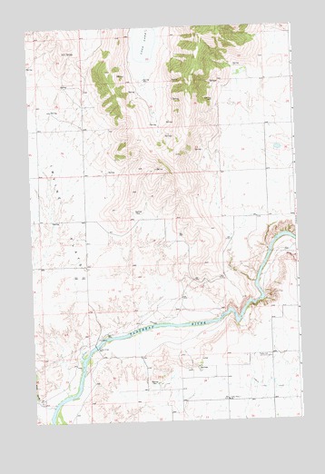
Buffalo Bridge, MT USGS Topographic Map
Click on map above to begin viewing in our Map Viewer.

This topographic map contains these locations and features:
Feature Name Type Latitude Longitude GNIS ID View Map
22N21W07ABC_01 WellWellN47.6855°W114.3382°824524View Map
22N21W09BCB_01 WellWellN47.6841°W114.3057°824520View Map
22N21W09BCBC01 WellWellN47.6838°W114.3057°824517View Map
22N21W17AAC_01 WellWellN47.6713°W114.3104°824437View Map
22N21W26ABB_01 WellWellN47.6452°W114.2512°824266View Map
22N21W28ACD_01 WellWellN47.6394°W114.2918°824214View Map
22N21W28DDDC01 WellWellN47.6319°W114.2862°824166View Map
22N21W28DDDD01 WellWellN47.6319°W114.2857°824165View Map
22N21W29ADD_01 WellWellN47.6391°W114.3071°824208View Map
22N21W30CBBA01 WellWellN47.6383°W114.3468°824201View Map
22N21W32ABAB01 WellWellN47.6308°W114.3132°824158View Map
22N21W35ABB_01 WellWellN47.6308°W114.2515°824157View Map
22N22W01CAA_01 WellWellN47.6955°W114.3607°824567View Map
22N22W01CAAA01 WellWellN47.6958°W114.3615°824572View Map
22N22W12ACD_01 WellWellN47.6819°W114.3548°824494View Map
22N22W13AAD_01 WellWellN47.6713°W114.3501°824438View Map
22N22W13ABD_01 WellWellN47.6710°W114.3551°824435View Map
22N22W24DAAA01 WellWellN47.6519°W114.3498°824321View Map
22N22W26DDDD01 WellWellN47.6313°W114.3715°824161View Map
23N21W19CBC_01 WellWellN47.7377°W114.3454°824756View Map
23N21W20BCB_01 WellWellN47.7458°W114.3262°824788View Map
23N21W23BCAA01 WellWellN47.7427°W114.2593°824775View Map
23N21W23CDC_01 WellWellN47.7336°W114.2585°824736View Map
23N21W26BAC_01 WellWellN47.7277°W114.2579°824706View Map
23N21W34AAAA01 WellWellN47.7183°W114.2646°824674View Map
23N21W34ADD_01 WellWellN47.7116°W114.2643°824649View Map
23N21W35BBA_01 WellWellN47.7172°W114.2590°824670View Map
23N22W25DBC_01 WellWellN47.7222°W114.3585°824688View Map
23N22W36CAA_01 WellWellN47.7097°W114.3610°824646View Map
Buffalo BridgeBridgeN47.6488°W114.3460°769336View Map
Loon LakeLakeN47.7451°W114.3196°773671View Map
Norrisvale Post Office (historical)Post OfficeN47.6455°W114.3482°1796846View Map
Pablo 31 A CanalCanalN47.6360°W114.2621°775031View Map
Radio Post Office (historical)Post OfficeN47.6883°W114.3715°1796837View Map
Radio School (historical)SchoolN47.6883°W114.3715°1796838View Map
Spring Valley (historical)Populated PlaceN47.6883°W114.3510°1796836View Map
Spring Valley School (historical)SchoolN47.6883°W114.3510°1796835View Map
Valley View Community CenterBuildingN47.6455°W114.2696°777979View Map
Valley View SchoolSchoolN47.6315°W114.2843°777981View Map
White Earth CreekStreamN47.6299°W114.3665°778377View Map

Note: Coordinates in the location and feature list above are referenced to NAD83 datum.


Copyright (C) 2008-2025 Ryan Niemi / Sunset Dynamics ... All Rights Reserved