TopoQuest Logo
Do you find TopoQuest useful?
Help keep TopoQuest running and adding new maps/features by donating!
Bitcoin:  19c7KJd3qBynnjoSw5npx9KScwjBe4ifkT
Litecoin:  LXs6TkuXGGXo1vDsWCkWVdjQX94eUKd6ui
Home View Maps Find Maps Find Places Resources & Links


Bullards, Oregon Topographic Map

USGS Map Title: Bullards, OR
USGS Map MRC: 43124B4
DRG (GeoTIFF) Download: o43124b4.tif


Neighboring USGS Topographic Map Quads:


  Cape Arago, OR  
43124C4
 

  Charleston, OR  
43124C3


  Bullards, OR  
43124B4
 

  Riverton, OR  
43124B3


  Bandon, OR  
43124A4
 

  Bill Peak, OR  
43124A3


Map MRC Location:

N44°
W125°
N44°
W124°
H8 H7 H6 H5 H4 H3 H2 H1
G8 G7 G6 G5 G4 G3 G2 G1
F8 F7 F6 F5 F4 F3 F2 F1
E8 E7 E6 E5 E4 E3 E2 E1
D8 D7 D6 D5 D4 D3 D2 D1
C8 C7 C6 C5 C4 C3 C2 C1
B8 B7 B6 B5 B4 B3 B2 B1
A8 A7 A6 A5 A4 A3 A2 A1
N43°
W125°
N43°
W124°

Bullards, OR USGS 1:24K Topographic Map Preview:
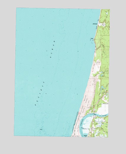
Bullards, OR USGS Topographic Map
Click on map above to begin viewing in our Map Viewer.

This topographic map contains these locations and features:
Feature Name Type Latitude Longitude GNIS ID View Map
Bandon Marsh National Wildlife RefugeParkN43.1480°W124.3896°2765187View Map
BullardsPopulated PlaceN43.1498°W124.3957°1136103View Map
Bullards Beach State ParkParkN43.1562°W124.4101°1118295View Map
Bullards Beach State Park Boat RampLocaleN43.1478°W124.4010°2668405View Map
Bullards Beach State Park Sewage Treatment PlantLocaleN43.1515°W124.4064°2660750View Map
Bullards BridgeBridgeN43.1472°W124.3956°1161293View Map
Bullards CemeteryCemeteryN43.1547°W124.3967°1118296View Map
Bullards Post Office (historical)Post OfficeN43.1498°W124.3957°1164980View Map
Chrome LakeReservoirN43.1881°W124.3856°1118935View Map
Coquille RockIslandN43.1312°W124.4637°1119277View Map
Cranberry CornersPopulated PlaceN43.1257°W124.3882°1638817View Map
Cut CreekStreamN43.1848°W124.4023°1161338View Map
Fahys CreekStreamN43.1471°W124.3896°1120553View Map
Fahys LakeLakeN43.1731°W124.3837°1120554View Map
Fivemile PointCapeN43.2204°W124.3976°1161368View Map
McKee GulchValleyN43.1451°W124.3929°1161222View Map
McKee SpringSpringN43.1357°W124.3921°1161231View Map
Merchants BeachBeachN43.2371°W124.3921°1161436View Map
Round LakeLakeN43.1853°W124.3858°1126322View Map
Seven Devils State ParkParkN43.2351°W124.3898°1126757View Map
Simpson CreekStreamN43.1329°W124.3971°1126991View Map
South Branch Cut CreekStreamN43.1873°W124.3887°1132159View Map
Spring CreekStreamN43.1384°W124.3957°1127417View Map
Spring Creek ReservoirReservoirN43.1372°W124.3783°1161230View Map
Spruce HollowValleyN43.1329°W124.3971°1127461View Map
The Lagoon (historical)LakeN43.1873°W124.3846°1829098View Map
Twomile CreekStreamN43.2362°W124.3923°1161565View Map
Whisky RunStreamN43.2109°W124.3954°1161586View Map
Whisky Run BeachBeachN43.2118°W124.3951°1161587View Map
Winters ReservoirReservoirN43.1378°W124.3827°1161229View Map

Note: Coordinates in the location and feature list above are referenced to NAD83 datum.


Copyright (C) 2008-2024 Ryan Niemi / Sunset Dynamics ... All Rights Reserved