TopoQuest Logo
Do you find TopoQuest useful?
Help keep TopoQuest running and adding new maps/features by donating!
Bitcoin:  19c7KJd3qBynnjoSw5npx9KScwjBe4ifkT
Litecoin:  LXs6TkuXGGXo1vDsWCkWVdjQX94eUKd6ui
Home View Maps Find Maps Find Places Resources & Links


Riverton, Oregon Topographic Map

USGS Map Title: Riverton, OR
USGS Map MRC: 43124B3
DRG (GeoTIFF) Download: o43124b3.tif


Neighboring USGS Topographic Map Quads:


  Cape Arago, OR  
43124C4
 

  Charleston, OR  
43124C3
 

  Coos Bay, OR  
43124C2
 

  Bullards, OR  
43124B4
 

  Riverton, OR  
43124B3
 

  Coquille, OR  
43124B2
 

  Bandon, OR  
43124A4
 

  Bill Peak, OR  
43124A3
 

  Myrtle Point, OR  
43124A2


Map MRC Location:

N44°
W125°
N44°
W124°
H8 H7 H6 H5 H4 H3 H2 H1
G8 G7 G6 G5 G4 G3 G2 G1
F8 F7 F6 F5 F4 F3 F2 F1
E8 E7 E6 E5 E4 E3 E2 E1
D8 D7 D6 D5 D4 D3 D2 D1
C8 C7 C6 C5 C4 C3 C2 C1
B8 B7 B6 B5 B4 B3 B2 B1
A8 A7 A6 A5 A4 A3 A2 A1
N43°
W125°
N43°
W124°

Riverton, OR USGS 1:24K Topographic Map Preview:
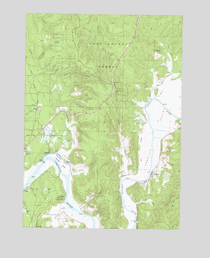
Riverton, OR USGS Topographic Map
Click on map above to begin viewing in our Map Viewer.

This topographic map contains these locations and features:
Feature Name Type Latitude Longitude GNIS ID View Map
Alder CreekStreamN43.1354°W124.2901°1116812View Map
Bandon Rural Fire Protection District Randolph StationBuildingN43.1857°W124.3632°2576784View Map
Bear CreekStreamN43.1371°W124.3387°1117366View Map
Beaver HillSummitN43.2048°W124.3032°1117446View Map
Beaver HillLocaleN43.2298°W124.2684°1117447View Map
Beaver LookoutLocaleN43.2054°W124.3026°1132142View Map
Beaver SloughStreamN43.2015°W124.2718°1117454View Map
Beaverton (historical)LocaleN43.2248°W124.2832°1132144View Map
Cannery Spring ck rcd dataSpringN43.1431°W124.3458°1161213View Map
Caufield GulchValleyN43.2318°W124.2637°1132147View Map
Caufield MarshSwampN43.2274°W124.2626°1132143View Map
Cedar CreekStreamN43.1596°W124.3484°1132149View Map
Central City Post Office (historical)Post OfficeN43.1996°W124.2776°1164264View Map
China CreekStreamN43.1948°W124.2612°1118908View Map
Clear CreekStreamN43.1582°W124.3721°1132152View Map
Coos County ForestForestN43.2271°W124.3098°1119256View Map
Coquille Fire Department Station 3BuildingN43.1571°W124.2732°2577133View Map
Coquille ValleyValleyN43.1540°W124.2921°1119278View Map
Eagle MineMineN43.1943°W124.3651°1132139View Map
Freedom Post Office (historical)Post OfficeN43.2015°W124.2721°1164371View Map
Hamdock CreekStreamN43.1357°W124.3362°1639062View Map
Hatchet SloughStreamN43.1540°W124.2959°1121660View Map
Hultin CemeteryCemeteryN43.1690°W124.3507°1122124View Map
Hultin CreekStreamN43.1693°W124.3498°1132146View Map
Iowa SloughStreamN43.1537°W124.2871°1158339View Map
Iowa Slough Post Office (historical)Post OfficeN43.1554°W124.2871°1164434View Map
Judah Parker County ParkParkN43.1421°W124.3440°1122546View Map
Kronenberg CemeteryCemeteryN43.1414°W124.3446°1122841View Map
LenevePopulated PlaceN43.2062°W124.2737°1136472View Map
Leneve Post Office (historical)Post OfficeN43.2062°W124.2737°1165529View Map
Lowe CreekStreamN43.1357°W124.3334°1123546View Map
Martin SpringSpringN43.1629°W124.2893°1161159View Map
Offield CreekStreamN43.1587°W124.3387°1124940View Map
ParkersburgPopulated PlaceN43.1429°W124.3423°1136616View Map
Parkersburgh Post Office (historical)Post OfficeN43.1429°W124.3423°1164581View Map
Peterson GulchValleyN43.1468°W124.3723°1125325View Map
Polly CreekStreamN43.1943°W124.3693°1132140View Map
Preuss Post Office (historical)Post OfficeN43.2298°W124.2682°1164614View Map
ProsperPopulated PlaceN43.1473°W124.3737°1136660View Map
Prosper Post Office (historical)Post OfficeN43.1473°W124.3737°1165825View Map
RandolphPopulated PlaceN43.1679°W124.3565°1158438View Map
Randolph CemeteryCemeteryN43.1701°W124.3557°1132145View Map
Randolph IslandIslandN43.1626°W124.3465°1125807View Map
Randolph Post Office (historical)Post OfficeN43.1679°W124.3565°1165835View Map
Randolph SloughGutN43.1651°W124.3454°1125808View Map
Red CreekStreamN43.1582°W124.3707°1132151View Map
Richardson GulchValleyN43.1351°W124.3465°1161203View Map
RivertonPopulated PlaceN43.1573°W124.2746°1136691View Map
Riverton Boat RampLocaleN43.1532°W124.2784°2058209View Map
Riverton Post Office (historical)Post OfficeN43.1573°W124.2746°1165863View Map
Rocky PointCapeN43.1637°W124.3612°1126244View Map
Rocky Point Boat RampLocaleN43.1634°W124.3618°2058210View Map
Rose MineMineN43.2221°W124.3415°1161161View Map
Russell CemeteryCemeteryN43.1765°W124.3389°1126370View Map
Russell ReservoirsReservoirN43.1815°W124.3556°1161178View Map
Seestrom CreekStreamN43.1443°W124.2957°1132148View Map
Seven Devils MineMineN43.2429°W124.3484°1638811View Map
Sevenmile CreekStreamN43.1679°W124.3490°1126762View Map
Sevenmile SloughStreamN43.1682°W124.3496°1161202View Map
Woolsey CreekStreamN43.1526°W124.2790°1132150View Map

Note: Coordinates in the location and feature list above are referenced to NAD83 datum.


Copyright (C) 2008-2024 Ryan Niemi / Sunset Dynamics ... All Rights Reserved