TopoQuest Logo
Do you find TopoQuest useful?
Help keep TopoQuest running and adding new maps/features by donating!
Bitcoin:  19c7KJd3qBynnjoSw5npx9KScwjBe4ifkT
Litecoin:  LXs6TkuXGGXo1vDsWCkWVdjQX94eUKd6ui
Home View Maps Find Maps Find Places Resources & Links


Bullis Spring Ranch, New Mexico Topographic Map

USGS Map Title: Bullis Spring Ranch, NM
USGS Map MRC: 32105E1
DRG (GeoTIFF) Download: o32105e1.tif


Neighboring USGS Topographic Map Quads:


  Lewis Peak, NM  
32105F2
 

  Lewis Peak NE, NM  
32105F1
 

  Encino Draw, NM  
32104F8
 

  Pinon Ranch, NM  
32105E2
 

  Bullis Spring Ranch, NM  
32105E1
 

  South Taylor Tank, NM  
32104E8
 

  Tanner Ranch, NM  
32105D2
 

  Panama Ranch, NM  
32105D1
 

  Packsaddle Canyon, NM  
32104D8


Map MRC Location:

N33°
W106°
N33°
W105°
H8 H7 H6 H5 H4 H3 H2 H1
G8 G7 G6 G5 G4 G3 G2 G1
F8 F7 F6 F5 F4 F3 F2 F1
E8 E7 E6 E5 E4 E3 E2 E1
D8 D7 D6 D5 D4 D3 D2 D1
C8 C7 C6 C5 C4 C3 C2 C1
B8 B7 B6 B5 B4 B3 B2 B1
A8 A7 A6 A5 A4 A3 A2 A1
N32°
W106°
N32°
W105°

Bullis Spring Ranch, NM USGS 1:24K Topographic Map Preview:
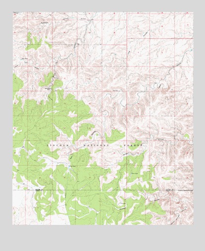
Bullis Spring Ranch, NM USGS Topographic Map
Click on map above to begin viewing in our Map Viewer.

This topographic map contains these locations and features:
Feature Name Type Latitude Longitude GNIS ID View Map
Buckhorn CanyonValleyN32.6204°W105.0708°904148View Map
Bullis SpringSpringN32.5798°W105.0983°932835View Map
Bullis Spring RanchLocaleN32.5795°W105.0989°904202View Map
Corner Storage TankReservoirN32.5998°W105.0683°936592View Map
Crip TankReservoirN32.5346°W105.0859°905506View Map
Crooked Storage TankReservoirN32.5154°W105.0066°1993966View Map
Crooked WellWellN32.5154°W105.0066°936598View Map
Dirt TankReservoirN32.6018°W105.0712°936591View Map
Dry LakeLakeN32.5012°W105.1050°936605View Map
East Bear SpringsSpringN32.5610°W105.0463°936601View Map
Foster TankReservoirN32.5304°W105.0432°906347View Map
Foster Water Storage TankReservoirN32.5198°W105.0497°936597View Map
Indian Trail CanyonValleyN32.5968°W105.0958°902901View Map
Indian Trail CreekStreamN32.5962°W105.0961°1984073View Map
Indian Water TankReservoirN32.5972°W105.1188°936562View Map
Lower Long Water TankReservoirN32.5851°W105.0725°924221View Map
Mean RanchLocaleN32.6207°W105.0744°908550View Map
New TankReservoirN32.5976°W105.1189°909066View Map
Prude RanchLocaleN32.5132°W105.0505°909868View Map
Sargent SeepSpringN32.5495°W105.0353°936596View Map
South Crooked CanyonValleyN32.5148°W105.0058°911223View Map
Steve Water Storage TankReservoirN32.5965°W105.1211°936593View Map
Tammy Water Storage TankReservoirN32.5918°W105.1164°936595View Map
Terry RanchLocaleN32.5787°W105.0516°911613View Map
Upper Bear Canyon Water Storage TankReservoirN32.5520°W105.0878°936599View Map
West Bear SpringsSpringN32.5597°W105.0495°936600View Map
West Crip Water Storage TankReservoirN32.5346°W105.1230°936606View Map

Note: Coordinates in the location and feature list above are referenced to NAD83 datum.


Copyright (C) 2008-2025 Ryan Niemi / Sunset Dynamics ... All Rights Reserved