TopoQuest Logo
Do you find TopoQuest useful?
Help keep TopoQuest running and adding new maps/features by donating!
Bitcoin:  19c7KJd3qBynnjoSw5npx9KScwjBe4ifkT
Litecoin:  LXs6TkuXGGXo1vDsWCkWVdjQX94eUKd6ui
Home View Maps Find Maps Find Places Resources & Links


Bunyan, North Carolina Topographic Map

USGS Map Title: Bunyan, NC
USGS Map MRC: 35076E8
DRG (GeoTIFF) Download: o35076e8.tif


Neighboring USGS Topographic Map Quads:


  Old Ford, NC  
35077F1
 

  Farmlife, NC  
35076F8
 

  Hoke, NC  
35076F7
 

  Washington, NC  
35077E1
 

  Bunyan, NC  
35076E8
 

  Pinetown, NC  
35076E7
 

  Hackney, NC  
35077D1
 

  Blounts Bay, NC  
35076D8
 

  Bath, NC  
35076D7


Map MRC Location:

N36°
W77°
N36°
W76°
H8 H7 H6 H5 H4 H3 H2 H1
G8 G7 G6 G5 G4 G3 G2 G1
F8 F7 F6 F5 F4 F3 F2 F1
E8 E7 E6 E5 E4 E3 E2 E1
D8 D7 D6 D5 D4 D3 D2 D1
C8 C7 C6 C5 C4 C3 C2 C1
B8 B7 B6 B5 B4 B3 B2 B1
A8 A7 A6 A5 A4 A3 A2 A1
N35°
W77°
N35°
W76°

Bunyan, NC USGS 1:24K Topographic Map Preview:
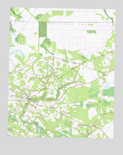
Bunyan, NC USGS Topographic Map
Click on map above to begin viewing in our Map Viewer.

This topographic map contains these locations and features:
Feature Name Type Latitude Longitude GNIS ID View Map
AlligoodsPopulated PlaceN35.5599°W76.9461°1018803View Map
Asbury ChurchChurchN35.5391°W76.9830°980303View Map
Beaverdam ChurchChurchN35.5343°W76.9699°980830View Map
Beaverdam SwampStreamN35.5371°W76.9583°980863View Map
Betsys ElbowBendN35.5666°W76.9427°981245View Map
Broad Creek Emergency Medical ServicesBuildingN35.5166°W76.9608°2720331View Map
BunyanPopulated PlaceN35.5379°W76.9752°1019408View Map
Bunyan Volunteer Fire DepartmentBuildingN35.5276°W76.9501°2638613View Map
Douglas CrossroadsPopulated PlaceN35.5288°W76.9494°1020020View Map
Five PointsPopulated PlaceN35.5618°W76.8866°1020262View Map
Hall SwampPopulated PlaceN35.5521°W76.9486°1008132View Map
Hall SwampStreamN35.5352°W76.9780°1026041View Map
J and W Dismal SwampSwampN35.6099°W76.9216°987460View Map
JessamaPopulated PlaceN35.5121°W76.9061°1018635View Map
MidwayPopulated PlaceN35.5118°W76.8997°1021442View Map
Mobiland Mobile Home ParkPopulated PlaceN35.5770°W76.9519°2505530View Map
PineygrovePopulated PlaceN35.5649°W76.9866°992398View Map
River RoadPopulated PlaceN35.5068°W76.9908°1867437View Map
River Road Census Designated PlaceCensusN35.5110°W76.9901°2403479View Map
River Road SchoolSchoolN35.5241°W76.9991°993376View Map
Rosemary ChurchChurchN35.5743°W76.9324°993708View Map
Saint Luke ChurchChurchN35.5249°W76.9936°1008166View Map
SlatestonePopulated PlaceN35.5727°W76.9222°994906View Map
Township of Long AcreCivilN35.6028°W76.9030°1026408View Map
Washington Water Treatment PlantLocaleN35.5251°W76.9602°2506344View Map
Woodwards Pond ChurchChurchN35.5124°W76.9088°997622View Map
Zion ChurchChurchN35.5224°W76.9341°997768View Map

Note: Coordinates in the location and feature list above are referenced to NAD83 datum.


Copyright (C) 2008-2025 Ryan Niemi / Sunset Dynamics ... All Rights Reserved