TopoQuest Logo
Do you find TopoQuest useful?
Help keep TopoQuest running and adding new maps/features by donating!
Bitcoin:  19c7KJd3qBynnjoSw5npx9KScwjBe4ifkT
Litecoin:  LXs6TkuXGGXo1vDsWCkWVdjQX94eUKd6ui
Home View Maps Find Maps Find Places Resources & Links


Buras, Louisiana Topographic Map

USGS Map Title: Buras, LA
USGS Map MRC: 29089C5
DRG (GeoTIFF) Download: o29089c5.tif


Neighboring USGS Topographic Map Quads:


  Port Sulphur, LA  
29089D6


  Coquille Point, LA  
29089D4
 

  Bastian Bay, LA  
29089C6
 

  Buras, LA  
29089C5
 

  Triumph, LA  
29089C4


  Bay Coquette, LA  
29089B5


Map MRC Location:

N30°
W90°
N30°
W89°
H8 H7 H6 H5 H4 H3 H2 H1
G8 G7 G6 G5 G4 G3 G2 G1
F8 F7 F6 F5 F4 F3 F2 F1
E8 E7 E6 E5 E4 E3 E2 E1
D8 D7 D6 D5 D4 D3 D2 D1
C8 C7 C6 C5 C4 C3 C2 C1
B8 B7 B6 B5 B4 B3 B2 B1
A8 A7 A6 A5 A4 A3 A2 A1
N29°
W90°
N29°
W89°

Buras, LA USGS 1:24K Topographic Map Preview:
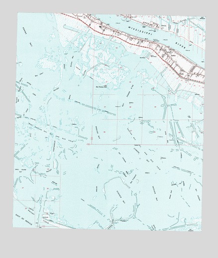
Buras, LA USGS Topographic Map
Click on map above to begin viewing in our Map Viewer.

This topographic map contains these locations and features:
Feature Name Type Latitude Longitude GNIS ID View Map
Adams BayLakeN29.3730°W89.6237°553261View Map
Bastian Bay Oil and Gas FieldOilfieldN29.2983°W89.5364°532328View Map
Bay Cheri (historical)BayN29.3394°W89.6095°532356View Map
Bay Crapaud (historical)BayN29.2808°W89.5456°532358View Map
Bay Jacquin (historical)LakeN29.2911°W89.5523°553382View Map
Bay Pomme d'Or (historical)BayN29.3336°W89.5556°540702View Map
Bayou Auguste (historical)GutN29.3080°W89.5551°542241View Map
Bayou CheriGutN29.3305°W89.6142°532510View Map
Bayou CrapaudGutN29.2827°W89.5506°532547View Map
Bayou FontanelleGutN29.2908°W89.5995°532596View Map
Bayou La Chute (historical)GutN29.3169°W89.6184°532652View Map
Bayou le Boon (historical)GutN29.3029°W89.5573°2746215View Map
Bayou Long (historical)GutN29.3372°W89.5937°532673View Map
Bayou PompadourGutN29.3508°W89.5570°558690View Map
Bayou TortillonGutN29.3358°W89.5812°532797View Map
BurasPopulated PlaceN29.3519°W89.5242°558181View Map
Buras Boat HarborHarborN29.3524°W89.5378°533550View Map
Buras Census Designated PlaceCensusN29.3528°W89.5248°2633175View Map
BURAS HIGH SCHOOLSchoolN29.3540°W89.5254°2493425View Map
Buras High School (historical)SchoolN29.3538°W89.5256°558619View Map
Buras RevetmentLeveeN29.3605°W89.5348°558620View Map
Buras Volunteer Fire DepartmentBuildingN29.3581°W89.5321°2332422View Map
Buras Wastewater Treatment PlantLocaleN29.3421°W89.5174°2603408View Map
Buras-Triumph Census Designated Place (historical)CensusN29.3479°W89.5011°2402733View Map
Cazezu CanalBayN29.3662°W89.5186°533831View Map
Cognevich CanalCanalN29.3538°W89.5403°558628View Map
Cross CanalCanalN29.3333°W89.5778°542245View Map
Cuselich CanalBayN29.3672°W89.5245°534310View Map
Cyprien Bay (historical)BayN29.2938°W89.5395°534379View Map
Drakes Bay (historical)LakeN29.3483°W89.5876°554264View Map
Drakes Bay Gas FieldOilfieldN29.3497°W89.5701°558634View Map
Dry Cypress Bayou (historical)GutN29.2872°W89.5145°534616View Map
Easterlings CanalCanalN29.3530°W89.5384°558636View Map
English Bay (historical)LakeN29.3052°W89.5695°554361View Map
English Bayou (historical)GutN29.2791°W89.5684°534824View Map
Ferrand BayouGutN29.3319°W89.6206°534938View Map
Little Bay Pomme d'Or (historical)LakeN29.3341°W89.5628°558256View Map
Long BayLakeN29.3052°W89.5242°555134View Map
Mingle CanalBayN29.3681°W89.5204°558666View Map
Mitchell CutChannelN29.2780°W89.5170°537168View Map
Mitchell PondLakeN29.2716°W89.5206°555341View Map
Mount Zion Church (historical)ChurchN29.3716°W89.5731°558668View Map
OstricaPopulated PlaceN29.3683°W89.5292°543562View Map
Ostrica LockDamN29.3677°W89.5298°558676View Map
Parish Governing Authority District 8CivilN29.2852°W89.5738°1930243View Map
Pelican IslandIslandN29.2530°W89.5998°538050View Map
Pilgrim Rest Church (historical)ChurchN29.3738°W89.5781°558681View Map
Quarantine (historical)Populated PlaceN29.3661°W89.5245°558696View Map
Scofield Bay (historical)LakeN29.2697°W89.5542°555992View Map
Scofield BayouGutN29.2536°W89.5587°539223View Map
Skipjack Bay (historical)BayN29.2722°W89.5312°558320View Map
SunrisePopulated PlaceN29.3666°W89.5628°558717View Map
Sunrise SchoolSchoolN29.3677°W89.5703°558718View Map
Swartse School (historical)SchoolN29.3716°W89.5731°558719View Map
West Bastian Bay Oil and Gas FieldOilfieldN29.3047°W89.6095°540296View Map
West Delta Brock 30 Terminal Seaplane BaseAirportN29.2674°W89.5992°1632696View Map

Note: Coordinates in the location and feature list above are referenced to NAD83 datum.


Copyright (C) 2008-2025 Ryan Niemi / Sunset Dynamics ... All Rights Reserved