TopoQuest Logo
Do you find TopoQuest useful?
Help keep TopoQuest running and adding new maps/features by donating!
Bitcoin:  19c7KJd3qBynnjoSw5npx9KScwjBe4ifkT
Litecoin:  LXs6TkuXGGXo1vDsWCkWVdjQX94eUKd6ui
Home View Maps Find Maps Find Places Resources & Links


Burge Mountain, Washington Topographic Map

USGS Map Title: Burge Mountain, WA
USGS Map MRC: 48119G3
DRG (GeoTIFF) Download: o48119g3.tif


Neighboring USGS Topographic Map Quads:


  Oroville, WA  
48119H4
 

  Mount Hull, WA  
48119H3
 

  Molson, WA  
48119H2
 

  Ellisforde, WA  
48119G4
 

  Burge Mountain, WA  
48119G3
 

  Havillah, WA  
48119G2
 

  Tonasket, WA  
48119F4
 

  Barker Mountain, WA  
48119F3
 

  Cayuse Mountain, WA  
48119F2


Map MRC Location:

N49°
W120°
N49°
W119°
H8 H7 H6 H5 H4 H3 H2 H1
G8 G7 G6 G5 G4 G3 G2 G1
F8 F7 F6 F5 F4 F3 F2 F1
E8 E7 E6 E5 E4 E3 E2 E1
D8 D7 D6 D5 D4 D3 D2 D1
C8 C7 C6 C5 C4 C3 C2 C1
B8 B7 B6 B5 B4 B3 B2 B1
A8 A7 A6 A5 A4 A3 A2 A1
N48°
W120°
N48°
W119°

Burge Mountain, WA USGS 1:24K Topographic Map Preview:
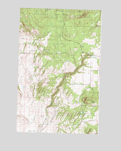
Burge Mountain, WA USGS Topographic Map
Click on map above to begin viewing in our Map Viewer.

This topographic map contains these locations and features:
Feature Name Type Latitude Longitude GNIS ID View Map
Box SpringsSpringN48.8482°W119.3136°1516907View Map
Burge MountainSummitN48.7818°W119.2664°1517108View Map
Camp SpringSpringN48.8597°W119.3289°1517314View Map
Ethel SpringSpringN48.8677°W119.3265°1519387View Map
Fancher QuarryMineN48.7609°W119.3235°2605759View Map
Fanchers DamDamN48.8299°W119.2645°1519474View Map
Fanchers Dam ReservoirReservoirN48.8275°W119.2592°1531985View Map
Granite SpringSpringN48.8734°W119.3025°1529025View Map
Green LakeLakeN48.8225°W119.3010°1520299View Map
Green SpringSpringN48.7808°W119.2747°1520331View Map
Haley MountainSummitN48.8729°W119.2851°1520453View Map
Harbor LakeLakeN48.7717°W119.2765°1520531View Map
Oberg LakeLakeN48.7939°W119.3655°1529026View Map
Okanogan County Fire District 12 HavillahBuildingN48.8332°W119.3373°2643914View Map
Oroville DivisionCivilN48.7910°W119.3062°1939593View Map
Saddle SpringSpringN48.8728°W119.3116°1525337View Map
Tamarack SpringSpringN48.8714°W119.3489°1529024View Map
Twin SpringsSpringN48.8620°W119.3092°1527563View Map
Wilcox MountainSummitN48.8585°W119.2545°1528122View Map
Wildhorse SpringSpringN48.8620°W119.3640°1528148View Map

Note: Coordinates in the location and feature list above are referenced to NAD83 datum.


Copyright (C) 2008-2025 Ryan Niemi / Sunset Dynamics ... All Rights Reserved