TopoQuest Logo
Do you find TopoQuest useful?
Help keep TopoQuest running and adding new maps/features by donating!
Bitcoin:  19c7KJd3qBynnjoSw5npx9KScwjBe4ifkT
Litecoin:  LXs6TkuXGGXo1vDsWCkWVdjQX94eUKd6ui
Home View Maps Find Maps Find Places Resources & Links


Burnaugh, Kentucky Topographic Map

USGS Map Title: Burnaugh, KY
USGS Map MRC: 38082C5
DRG (GeoTIFF) Download: o38082c5.tif


Neighboring USGS Topographic Map Quads:


  Ashland, KY  
38082D6
 

  Catlettsburg, KY  
38082D5
 

  Huntington, WV  
38082D4
 

  Boltsfork, KY  
38082C6
 

  Burnaugh, KY  
38082C5
 

  Lavalette, WV  
38082C4
 

  Fallsburg, KY  
38082B6
 

  Prichard, WV  
38082B5
 

  Wayne, WV  
38082B4


Map MRC Location:

N39°
W83°
N39°
W82°
H8 H7 H6 H5 H4 H3 H2 H1
G8 G7 G6 G5 G4 G3 G2 G1
F8 F7 F6 F5 F4 F3 F2 F1
E8 E7 E6 E5 E4 E3 E2 E1
D8 D7 D6 D5 D4 D3 D2 D1
C8 C7 C6 C5 C4 C3 C2 C1
B8 B7 B6 B5 B4 B3 B2 B1
A8 A7 A6 A5 A4 A3 A2 A1
N38°
W83°
N38°
W82°

Burnaugh, KY USGS 1:24K Topographic Map Preview:
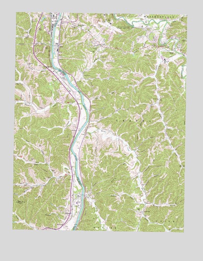
Burnaugh, KY USGS Topographic Map
Click on map above to begin viewing in our Map Viewer.

This topographic map contains these locations and features:
Feature Name Type Latitude Longitude GNIS ID View Map
Akers CemeteryCemeteryN38.3098°W82.5705°2728222View Map
Balangee BranchStreamN38.2662°W82.5285°1535161View Map
Big Sandy Fire DepartmentBuildingN38.2747°W82.5815°2636303View Map
Black CemeteryCemeteryN38.2611°W82.5864°2088958View Map
Blacks CemeteryCemeteryN38.2748°W82.6124°487420View Map
Bobs BranchStreamN38.3704°W82.5143°1536182View Map
Braskem America's Neal Plant AmbulanceBuildingN38.3575°W82.5954°2581214View Map
Bryants CemeteryCemeteryN38.3204°W82.6040°488176View Map
Buffalo CreekPopulated PlaceN38.3556°W82.5093°1536620View Map
Buffalo CreekStreamN38.3545°W82.5082°1536630View Map
Buffalo Elementary SchoolSchoolN38.3495°W82.5158°1728899View Map
Buffalo High School (historical)SchoolN38.3484°W82.5157°1728900View Map
Buffalo Middle SchoolSchoolN38.3482°W82.5131°2088145View Map
Buffalo Valley ChurchChurchN38.3259°W82.5193°1536659View Map
Burgess Railroad Station (historical)LocaleN38.2867°W82.5822°2088952View Map
Burgess Railroad Station (historical)LocaleN38.2724°W82.5815°2088957View Map
BurnaughPopulated PlaceN38.2604°W82.5815°488442View Map
Burnaugh Missionary Baptist ChurchChurchN38.2599°W82.5820°2088961View Map
Campbell RunStreamN38.3567°W82.5982°488739View Map
Catlettsburg DivisionCivilN38.3432°W82.6155°1936924View Map
Cedar RunStreamN38.3259°W82.5746°1537139View Map
CentervillePopulated PlaceN38.2615°W82.5296°1554097View Map
Clarkson CemeteryCemeteryN38.3340°W82.6230°2088948View Map
CyrusPopulated PlaceN38.3054°W82.5727°1554248View Map
Cyrus CemeteryCemeteryN38.2987°W82.6068°490534View Map
Cyrus ChapelChurchN38.2834°W82.5960°490535View Map
Cyrus HollowValleyN38.2888°W82.6014°490536View Map
Dock CreekStreamN38.3354°W82.5846°1538223View Map
Dock Creek CemeteryCemeteryN38.3529°W82.5663°1538224View Map
Dock Creek ChurchChurchN38.3390°W82.5752°1538225View Map
Dog ForkStreamN38.3226°W82.6238°490980View Map
DurbinPopulated PlaceN38.2793°W82.5982°507893View Map
Durbin ChurchChurchN38.2887°W82.6088°491340View Map
Durbin CreekStreamN38.2870°W82.5796°491341View Map
Durbin SchoolSchoolN38.2838°W82.5956°2088955View Map
Durbin-Burnaugh (historical)Populated PlaceN38.2599°W82.5820°2088960View Map
Ebenzer ChurchChurchN38.3673°W82.5818°1538538View Map
Ellis ForkStreamN38.3426°W82.5729°1728931View Map
Gragston CreekStreamN38.2701°W82.5732°1539563View Map
Hall CemeteryCemeteryN38.2792°W82.5815°493581View Map
Hatten CemeteryCemeteryN38.2831°W82.5946°2088954View Map
Hatton BranchStreamN38.2751°W82.6115°493871View Map
Hensley BranchStreamN38.2840°W82.5307°1540165View Map
Hidden ValleyPopulated PlaceN38.3579°W82.5393°1728955View Map
Hillcrest CemeteryCemeteryN38.3545°W82.5649°1540299View Map
Huntington Tri State Airport Police DepartmentBuildingN38.3694°W82.5558°2727655View Map
James and Carol Wheeler BridgeBridgeN38.3719°W82.5453°2647370View Map
Jim Wood Post Office (historical)Post OfficeN38.2809°W82.5965°2088953View Map
Johnston CemeteryCemeteryN38.3247°W82.5787°2088947View Map
KavanaughPopulated PlaceN38.2534°W82.5868°508370View Map
Kavanaugh Chapel ChurchChurchN38.2527°W82.5873°2088962View Map
Kavanaugh SchoolSchoolN38.2528°W82.5881°2088964View Map
Kenova Volunteer Fire Department Station 2BuildingN38.3552°W82.5315°2577640View Map
Leach Railroad Station (historical)LocaleN38.3570°W82.5996°2088737View Map
Leach Station ChurchChurchN38.3586°W82.5997°2088738View Map
Left Fork Durbin CreekStreamN38.2806°W82.5957°496213View Map
LockwoodPopulated PlaceN38.3084°W82.5802°508483View Map
Lockwood CemeteryCemeteryN38.3095°W82.5800°2088949View Map
Lockwood CemeteryCemeteryN38.3456°W82.6154°496935View Map
Lockwood CreekStreamN38.3234°W82.5757°496936View Map
Lockwood Ferry (historical)LocaleN38.3075°W82.5780°2088951View Map
Lockwood Railroad Station (historical)LocaleN38.2867°W82.5822°2088950View Map
Locust Grove ChurchChurchN38.3559°W82.5071°1542293View Map
Mary Moore School (historical)SchoolN38.3248°W82.5788°2088946View Map
Meadow HavenPopulated PlaceN38.3598°W82.5165°1728975View Map
Merrick BranchStreamN38.2756°W82.5310°1543129View Map
Mills ChapelChurchN38.2879°W82.5015°1543412View Map
Mount Zion ChurchChurchN38.2698°W82.5693°1543817View Map
NealPopulated PlaceN38.3567°W82.5929°1555192View Map
Newman CemeteryCemeteryN38.2599°W82.5785°2088959View Map
Plymale CemeteryCemeteryN38.3323°W82.5022°2586319View Map
Potomac Post Office (historical)Post OfficeN38.3235°W82.6140°2088741View Map
Prichard BranchStreamN38.2506°W82.5804°501332View Map
Rawles CemeteryCemeteryN38.2898°W82.6118°501609View Map
Riggs CemeteryCemeteryN38.2620°W82.5329°1545598View Map
Rocklick BranchStreamN38.2668°W82.5302°1545989View Map
Runyon CemeteryCemeteryN38.3684°W82.6044°2088736View Map
Savage BranchStreamN38.3434°W82.5968°503004View Map
Savage BranchPopulated PlaceN38.3442°W82.5979°509019View Map
Sharps BranchStreamN38.3126°W82.5710°1546626View Map
Silver RunStreamN38.3217°W82.6124°503516View Map
Sours RunStreamN38.2909°W82.5340°1547060View Map
Sweet RunPopulated PlaceN38.3670°W82.5802°1555767View Map
Tennessee Gas HeliportAirportN38.2684°W82.5774°517344View Map
Thacker CemeteryCemeteryN38.2812°W82.5924°505104View Map
Tri-State Airport/Milton J Ferguson FieldAirportN38.3644°W82.5558°1558801View Map
Tri-state ChurchChurchN38.3565°W82.5615°1548264View Map
Walker BranchStreamN38.3695°W82.5277°1548715View Map
Ward CemeteryCemeteryN38.2808°W82.5319°2586338View Map
Washington ChurchChurchN38.3717°W82.5154°1548818View Map
Westmoreland DistrictCivilN38.3740°W82.5003°1928417View Map
White Creek ChurchChurchN38.3229°W82.6132°506581View Map
Whites CreekStreamN38.3420°W82.5932°506672View Map
Whites CreekStreamN38.3095°W82.5735°1549094View Map
Whites Creek (historical)Populated PlaceN38.3407°W82.6114°2088740View Map
Whites Creek ChurchChurchN38.3407°W82.6114°2088739View Map
Wright Railroad Station (historical)LocaleN38.2527°W82.5873°2088963View Map

Note: Coordinates in the location and feature list above are referenced to NAD83 datum.


Copyright (C) 2008-2024 Ryan Niemi / Sunset Dynamics ... All Rights Reserved