TopoQuest Logo
Do you find TopoQuest useful?
Help keep TopoQuest running and adding new maps/features by donating!
Bitcoin:  19c7KJd3qBynnjoSw5npx9KScwjBe4ifkT
Litecoin:  LXs6TkuXGGXo1vDsWCkWVdjQX94eUKd6ui
Home View Maps Find Maps Find Places Resources & Links


Wayne, West Virginia Topographic Map

USGS Map Title: Wayne, WV
USGS Map MRC: 38082B4
DRG (GeoTIFF) Download: o38082b4.tif


Neighboring USGS Topographic Map Quads:


  Burnaugh, KY  
38082C5
 

  Lavalette, WV  
38082C4
 

  Winslow, WV  
38082C3
 

  Prichard, WV  
38082B5
 

  Wayne, WV  
38082B4
 

  Nestlow, WV  
38082B3
 

  Louisa, KY  
38082A5
 

  Radnor, WV  
38082A4
 

  Kiahsville, WV  
38082A3


Map MRC Location:

N39°
W83°
N39°
W82°
H8 H7 H6 H5 H4 H3 H2 H1
G8 G7 G6 G5 G4 G3 G2 G1
F8 F7 F6 F5 F4 F3 F2 F1
E8 E7 E6 E5 E4 E3 E2 E1
D8 D7 D6 D5 D4 D3 D2 D1
C8 C7 C6 C5 C4 C3 C2 C1
B8 B7 B6 B5 B4 B3 B2 B1
A8 A7 A6 A5 A4 A3 A2 A1
N38°
W83°
N38°
W82°

Wayne, WV USGS 1:24K Topographic Map Preview:
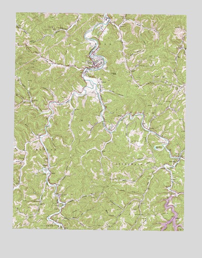
Wayne, WV USGS Topographic Map
Click on map above to begin viewing in our Map Viewer.

This topographic map contains these locations and features:
Feature Name Type Latitude Longitude GNIS ID View Map
Adkins CemeteryCemeteryN38.1895°W82.3757°1534828View Map
ArmildaPopulated PlaceN38.1837°W82.4015°1549568View Map
Bailey CemeteryCemeteryN38.2404°W82.4729°1535125View Map
Ball CemeteryCemeteryN38.1415°W82.4932°1535176View Map
Bartram BranchStreamN38.1276°W82.3801°1535295View Map
Battern ForkStreamN38.1606°W82.3938°1535310View Map
BethesdaPopulated PlaceN38.1895°W82.4227°1553876View Map
Big BranchStreamN38.1998°W82.4596°1535797View Map
Big Branch School (historical)SchoolN38.1943°W82.4565°1535812View Map
Big Lynn School (historical)SchoolN38.1343°W82.4065°1535887View Map
Booth BranchStreamN38.2240°W82.4193°1536234View Map
Booth BranchStreamN38.1770°W82.4815°1536235View Map
Brush CreekStreamN38.1320°W82.3826°1536464View Map
Camp CreekStreamN38.1676°W82.3779°1536916View Map
Clark CemeteryCemeteryN38.1462°W82.3854°1537354View Map
ColemanPopulated PlaceN38.1623°W82.4749°1554176View Map
Comfort ChurchChurchN38.1406°W82.4068°1537548View Map
Community CemeteryCemeteryN38.1895°W82.4075°2586139View Map
Community Memorial Gardens-Dickerson CemeteryCemeteryN38.2047°W82.4430°2586331View Map
Crabtree CemeteryCemeteryN38.1359°W82.4971°1537769View Map
CrockettPopulated PlaceN38.2315°W82.3776°1554225View Map
Crockett CemeteryCemeteryN38.2468°W82.4204°1537829View Map
Deadwood HollowValleyN38.1993°W82.4704°1538092View Map
Dean CemeteryCemeteryN38.2068°W82.3921°1538095View Map
Deephole BranchStreamN38.1401°W82.4615°1538113View Map
East Fork Twelvepole CreekStreamN38.2115°W82.4454°1538505View Map
East LynnPopulated PlaceN38.1679°W82.3779°1538508View Map
East Lynn DamDamN38.1450°W82.3841°1559322View Map
East Lynn Elementary SchoolSchoolN38.1625°W82.3835°1728926View Map
East Lynn Post OfficePost OfficeN38.1620°W82.3910°1728927View Map
East Lynn Volunteer Fire DepartmentBuildingN38.1643°W82.3817°2577567View Map
EchoPopulated PlaceN38.1779°W82.4818°1549667View Map
Echo ChurchChurchN38.1984°W82.4740°1538541View Map
Edds BranchStreamN38.1898°W82.4138°1538544View Map
ElmwoodPopulated PlaceN38.2087°W82.4374°1538692View Map
Elmwood CemeteryCemeteryN38.2079°W82.4382°1538693View Map
Ferguson CemeteryCemeteryN38.1368°W82.4102°1538920View Map
Ferguson CemeteryCemeteryN38.1393°W82.4643°1538921View Map
Flat BranchStreamN38.1281°W82.4665°1539043View Map
Fraley ForkStreamN38.2309°W82.3774°1539213View Map
Fry CemeteryCemeteryN38.1298°W82.3796°1551191View Map
Garrett Creek School (historical)SchoolN38.2404°W82.4654°1539347View Map
Genoa Elementary SchoolSchoolN38.1271°W82.4627°2088209View Map
Greenbrier ChurchChurchN38.1654°W82.4921°1539700View Map
Greenbrier CreekStreamN38.1643°W82.4921°1539703View Map
Hopewell ChurchChurchN38.1393°W82.4802°1540443View Map
Jackson CemeteryCemeteryN38.1590°W82.4763°1540775View Map
Joels BranchStreamN38.1531°W82.4754°1540924View Map
Joels Branch CemeteryCemeteryN38.1315°W82.4885°1540925View Map
Joels Branch School (historical)SchoolN38.1412°W82.4799°1540926View Map
Johnnys BranchStreamN38.2065°W82.4404°1540959View Map
Kennedy ChapelChurchN38.2173°W82.4152°1541152View Map
Kilpeck BranchStreamN38.1951°W82.4338°1541194View Map
Lambert BranchStreamN38.1493°W82.4685°1541326View Map
Laurel CreekStreamN38.1468°W82.3807°1541421View Map
Left Fork Lynn CreekStreamN38.1418°W82.4065°1541686View Map
Left Fork Wilson CreekStreamN38.2423°W82.4257°1541747View Map
Lick BranchStreamN38.1306°W82.4529°1541852View Map
Little Lynn CreekStreamN38.1681°W82.3782°1542167View Map
Lucas CemeteryCemeteryN38.1320°W82.4021°1542605View Map
Luster ForkStreamN38.1456°W82.4046°1542615View Map
Lynn CreekStreamN38.1620°W82.3899°1542639View Map
Lynn HollowValleyN38.2420°W82.4074°1542645View Map
Mam-Maw LakeLakeN38.1730°W82.3968°1542704View Map
Maynard CemeteryCemeteryN38.1270°W82.4299°1542904View Map
Meeks BranchStreamN38.1323°W82.4238°1543109View Map
Middle Fork Wilson CreekStreamN38.2470°W82.4207°1543198View Map
Mills CemeteryCemeteryN38.1765°W82.4085°1543274View Map
Napier CemeteryCemeteryN38.1615°W82.3865°1544044View Map
Newcomb CreekStreamN38.1831°W82.4027°1544144View Map
Newcomb Creek ChurchChurchN38.1995°W82.3860°1544146View Map
Onemile CreekStreamN38.1879°W82.4352°1544406View Map
Patrick CreekStreamN38.1965°W82.4743°1544616View Map
Patrick Creek ChurchChurchN38.1990°W82.4874°1544617View Map
Petercave BranchStreamN38.1823°W82.4010°1544742View Map
Ramey CemeteryCemeteryN38.1351°W82.3910°1545393View Map
Right Fork Lynn CreekStreamN38.1418°W82.4068°1545674View Map
Rockhouse BranchStreamN38.1368°W82.4188°1545971View Map
Rocky HollowValleyN38.1798°W82.4752°1546025View Map
Sand GapGapN38.2290°W82.4913°1546358View Map
SidneyPopulated PlaceN38.1570°W82.4727°1555623View Map
Smith CemeteryCemeteryN38.1570°W82.4752°1546965View Map
Smith CemeteryCemeteryN38.1751°W82.4821°1546966View Map
Spurlock ChurchChurchN38.2429°W82.4243°1547287View Map
Stephens CemeteryCemeteryN38.2081°W82.3807°1547381View Map
StiltnerPopulated PlaceN38.1320°W82.3804°1555713View Map
Sycamore BranchStreamN38.1365°W82.4649°1547818View Map
Sycamore School (historical)SchoolN38.1318°W82.4563°1547849View Map
Toms CreekStreamN38.2179°W82.4493°1548137View Map
Toms Creek ChurchChurchN38.2209°W82.4721°1548138View Map
Town of WayneCivilN38.2251°W82.4416°2391474View Map
Trace ForkStreamN38.1776°W82.4807°1548224View Map
Twelvepole Valley ChurchChurchN38.1445°W82.4671°1548393View Map
Twomile CreekStreamN38.1812°W82.4293°1548430View Map
Twomile School (historical)SchoolN38.1704°W82.4357°1548440View Map
Vine CemeteryCemeteryN38.1762°W82.3901°1548675View Map
WaynePopulated PlaceN38.2215°W82.4424°1548850View Map
Wayne CemeteryCemeteryN38.2206°W82.4396°2586207View Map
Wayne CountyCivilN38.1459°W82.4269°1550056View Map
Wayne County CourthouseBuildingN38.2198°W82.4415°2727858View Map
Wayne County Sheriff's OfficeBuildingN38.2211°W82.4427°2727663View Map
Wayne High SchoolSchoolN38.2467°W82.4343°1548853View Map
Wayne Middle SchoolSchoolN38.2451°W82.4350°1729017View Map
Wayne Police DepartmentBuildingN38.2274°W82.4434°2728214View Map
Wayne Post OfficePost OfficeN38.2224°W82.4426°1729018View Map
Wayne Public LibraryBuildingN38.2222°W82.4410°2727387View Map
Wayne Volunteer Fire DepartmentBuildingN38.2130°W82.4504°2577538View Map
West Fork Twelvepole CreekStreamN38.2115°W82.4454°1548932View Map
West Virginia State Police Troop 5 - Wayne DetachmentBuildingN38.2268°W82.4426°2727657View Map
Wheeler KnobSummitN38.2154°W82.4254°1548992View Map
White Oak ForkStreamN38.2179°W82.4160°1549057View Map
Wilson CreekStreamN38.2462°W82.4315°1549219View Map
Wilson School (historical)SchoolN38.1509°W82.4682°1549232View Map
Wolf CreekStreamN38.1706°W82.4913°1549268View Map

Note: Coordinates in the location and feature list above are referenced to NAD83 datum.


Copyright (C) 2008-2025 Ryan Niemi / Sunset Dynamics ... All Rights Reserved