TopoQuest Logo
Do you find TopoQuest useful?
Help keep TopoQuest running and adding new maps/features by donating!
Bitcoin:  19c7KJd3qBynnjoSw5npx9KScwjBe4ifkT
Litecoin:  LXs6TkuXGGXo1vDsWCkWVdjQX94eUKd6ui
Home View Maps Find Maps Find Places Resources & Links


Burro Mesa, Arizona Topographic Map

USGS Map Title: Burro Mesa, AZ
USGS Map MRC: 34113G2
DRG (GeoTIFF) Download: o34113g2.tif


Neighboring USGS Topographic Map Quads:


  Mohon Peak, AZ  
34113H3
 

  Sunrise Peak, AZ  
34113H2
 

  Mount Hope, AZ  
34113H1
 

  Pilot Knob, AZ  
34113G3
 

  Burro Mesa, AZ  
34113G2
 

  Scratch Canyon, AZ  
34113G1
 

  Negro Ed, AZ  
34113F3
 

  Bozarth Mesa, AZ  
34113F2
 

  Behm Mesa, AZ  
34113F1


Map MRC Location:

N35°
W114°
N35°
W113°
H8 H7 H6 H5 H4 H3 H2 H1
G8 G7 G6 G5 G4 G3 G2 G1
F8 F7 F6 F5 F4 F3 F2 F1
E8 E7 E6 E5 E4 E3 E2 E1
D8 D7 D6 D5 D4 D3 D2 D1
C8 C7 C6 C5 C4 C3 C2 C1
B8 B7 B6 B5 B4 B3 B2 B1
A8 A7 A6 A5 A4 A3 A2 A1
N34°
W114°
N34°
W113°

Burro Mesa, AZ USGS 1:24K Topographic Map Preview:
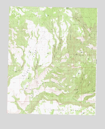
Burro Mesa, AZ USGS Topographic Map
Click on map above to begin viewing in our Map Viewer.

This topographic map contains these locations and features:
Feature Name Type Latitude Longitude GNIS ID View Map
Big SpringSpringN34.8331°W113.1760°21172View Map
Bolix HollowBasinN34.7992°W113.2396°21191View Map
Brushy BasinBasinN34.8225°W113.1466°21195View Map
Brushy Basin TankReservoirN34.8233°W113.1476°21198View Map
Bull CreekStreamN34.7656°W113.1446°38286View Map
Burro MesaSummitN34.8131°W113.2113°21202View Map
Burro Mesa DamDamN34.8211°W113.2163°21203View Map
Burro Mesa TankReservoirN34.8220°W113.2167°21204View Map
Cold SpringSpringN34.8439°W113.1346°21225View Map
Cold Spring CanyonValleyN34.8406°W113.1335°21226View Map
Conger CreekStreamN34.7684°W113.2158°27844View Map
Conger DamDamN34.7520°W113.1446°21228View Map
Conger TankReservoirN34.7524°W113.1439°21229View Map
Cypress CreekStreamN34.7684°W113.1599°21245View Map
First TankReservoirN34.7915°W113.2189°21264View Map
Happy Hollow CanyonValleyN34.8097°W113.1760°21280View Map
Hellzapoppin CanyonValleyN34.8303°W113.1571°21284View Map
Hellzapoppin CreekStreamN34.8306°W113.1569°21285View Map
Jerky CanyonValleyN34.8336°W113.1430°38537View Map
Johnson Flat TankReservoirN34.8741°W113.1701°21306View Map
Juan TankReservoirN34.8216°W113.1955°21309View Map
Little Cypress CreekStreamN34.7781°W113.1502°21320View Map
Little Juan TankReservoirN34.8060°W113.2035°21321View Map
Lovelace TankReservoirN34.7805°W113.2255°21326View Map
McElheny TankReservoirN34.7986°W113.1514°21337View Map
Middle Water CanyonValleyN34.7817°W113.2049°21340View Map
Oley TankReservoirN34.8651°W113.1974°21368View Map
Orejans CanyonValleyN34.7861°W113.1996°21371View Map
Scratch CanyonValleyN34.8409°W113.1263°38785View Map
Shirttail MesaSummitN34.7781°W113.1744°21438View Map
Soda SpringSpringN34.8200°W113.1521°21446View Map
Suicide TankReservoirN34.8156°W113.1352°21458View Map
Upper Cypress SpringSpringN34.7783°W113.1262°21476View Map

Note: Coordinates in the location and feature list above are referenced to NAD83 datum.


Copyright (C) 2008-2025 Ryan Niemi / Sunset Dynamics ... All Rights Reserved