TopoQuest Logo
Do you find TopoQuest useful?
Help keep TopoQuest running and adding new maps/features by donating!
Bitcoin:  19c7KJd3qBynnjoSw5npx9KScwjBe4ifkT
Litecoin:  LXs6TkuXGGXo1vDsWCkWVdjQX94eUKd6ui
Home View Maps Find Maps Find Places Resources & Links


Bozarth Mesa, Arizona Topographic Map

USGS Map Title: Bozarth Mesa, AZ
USGS Map MRC: 34113F2
DRG (GeoTIFF) Download: o34113f2.tif


Neighboring USGS Topographic Map Quads:


  Pilot Knob, AZ  
34113G3
 

  Burro Mesa, AZ  
34113G2
 

  Scratch Canyon, AZ  
34113G1
 

  Negro Ed, AZ  
34113F3
 

  Bozarth Mesa, AZ  
34113F2
 

  Behm Mesa, AZ  
34113F1
 

  Grayback Mountains, AZ  
34113E3
 

  Bagdad, AZ  
34113E2
 

  Big Shipp Mountain, AZ  
34113E1


Map MRC Location:

N35°
W114°
N35°
W113°
H8 H7 H6 H5 H4 H3 H2 H1
G8 G7 G6 G5 G4 G3 G2 G1
F8 F7 F6 F5 F4 F3 F2 F1
E8 E7 E6 E5 E4 E3 E2 E1
D8 D7 D6 D5 D4 D3 D2 D1
C8 C7 C6 C5 C4 C3 C2 C1
B8 B7 B6 B5 B4 B3 B2 B1
A8 A7 A6 A5 A4 A3 A2 A1
N34°
W114°
N34°
W113°

Bozarth Mesa, AZ USGS 1:24K Topographic Map Preview:
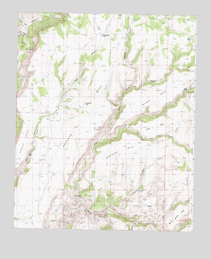
Bozarth Mesa, AZ USGS Topographic Map
Click on map above to begin viewing in our Map Viewer.

This topographic map contains these locations and features:
Feature Name Type Latitude Longitude GNIS ID View Map
Bozarth MesaSummitN34.7286°W113.1819°25342View Map
Bozarth PointCapeN34.6747°W113.2452°1927View Map
Bozarth RanchLocaleN34.6903°W113.2235°1928View Map
Brushy Basin TankReservoirN34.7375°W113.1915°2029View Map
Bull Spring WashStreamN34.6295°W113.1646°43559View Map
Butcher Corral PointCliffN34.6417°W113.1955°2294View Map
Cold SpringSpringN34.6678°W113.2407°3104View Map
Contreras MesaSummitN34.6653°W113.1760°3184View Map
Contreras WashStreamN34.6386°W113.1819°3185View Map
Francis CreekStreamN34.7411°W113.2435°4818View Map
Hillside MineMineN34.6328°W113.2105°5822View Map
Lang TankReservoirN34.7364°W113.1284°30877View Map
Long PointCliffN34.6897°W113.1552°7348View Map
Pinky CanyonValleyN34.7375°W113.2441°21388View Map
Rock Tank CanyonValleyN34.6839°W113.1735°33747View Map
Seligman CanyonValleyN34.7081°W113.1708°11071View Map
Stone Corral CanyonValleyN34.6761°W113.1913°34866View Map
Tod Reese TankReservoirN34.6978°W113.2019°12521View Map
Urie BasinBasinN34.6384°W113.1619°13137View Map
Urie SpringSpringN34.6478°W113.1633°21479View Map
Warm SpringSpringN34.6328°W113.1469°13348View Map
Warm Spring CreekStreamN34.6286°W113.1488°35895View Map
Warm Spring PointCapeN34.6331°W113.1321°35896View Map
Wilder CreekStreamN34.6400°W113.2041°36195View Map
Wilder PointCliffN34.6984°W113.1474°13793View Map
Wilder SpringSpringN34.7086°W113.1283°36197View Map
Zana CanyonValleyN34.6711°W113.2385°14127View Map

Note: Coordinates in the location and feature list above are referenced to NAD83 datum.


Copyright (C) 2008-2025 Ryan Niemi / Sunset Dynamics ... All Rights Reserved