TopoQuest Logo
Do you find TopoQuest useful?
Help keep TopoQuest running and adding new maps/features by donating!
Bitcoin:  19c7KJd3qBynnjoSw5npx9KScwjBe4ifkT
Litecoin:  LXs6TkuXGGXo1vDsWCkWVdjQX94eUKd6ui
Home View Maps Find Maps Find Places Resources & Links


Burtons Ferry Landing, Georgia Topographic Map

USGS Map Title: Burtons Ferry Landing, GA
USGS Map MRC: 32081H5
DRG (GeoTIFF) Download: o32081h5.tif


Neighboring USGS Topographic Map Quads:


  Girard, GA  
33081A6
 

  Millett, SC  
33081A5
 

  Martin, SC  
33081A4
 

  Hilltonia, GA  
32081H6
 

  Burtons Ferry Landing, GA  
32081H5
 

  Bull Pond, SC  
32081H4
 

  Sylvania North, GA  
32081G6
 

  Jacksonboro Bridge, GA  
32081G5
 

  Brier Creek Landing, GA  
32081G4


Map MRC Location:

N33°
W82°
N33°
W81°
H8 H7 H6 H5 H4 H3 H2 H1
G8 G7 G6 G5 G4 G3 G2 G1
F8 F7 F6 F5 F4 F3 F2 F1
E8 E7 E6 E5 E4 E3 E2 E1
D8 D7 D6 D5 D4 D3 D2 D1
C8 C7 C6 C5 C4 C3 C2 C1
B8 B7 B6 B5 B4 B3 B2 B1
A8 A7 A6 A5 A4 A3 A2 A1
N32°
W82°
N32°
W81°

Burtons Ferry Landing, GA USGS 1:24K Topographic Map Preview:
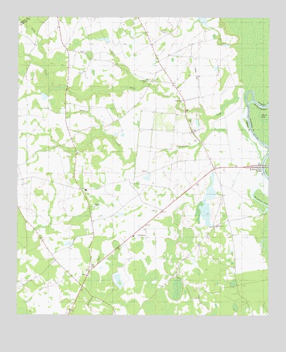
Burtons Ferry Landing, GA USGS Topographic Map
Click on map above to begin viewing in our Map Viewer.

This topographic map contains these locations and features:
Feature Name Type Latitude Longitude GNIS ID View Map
Bethel Brick ChurchChurchN32.9652°W81.5423°354586View Map
Bethel CemeteryCemeteryN32.9657°W81.5429°350152View Map
Burtons Ferry (historical)CrossingN32.9374°W81.5029°1233109View Map
Burtons Ferry (historical)CrossingN32.9374°W81.5029°334723View Map
Burtons Ferry BridgeBridgeN32.9379°W81.5029°350161View Map
Burtons Ferry LandingPopulated PlaceN32.9368°W81.5040°331292View Map
Canes Store (historical)LocaleN32.9727°W81.5479°334724View Map
Carter LakeReservoirN32.9668°W81.6118°340337View Map
Carter Lake DamDamN32.9668°W81.6098°340336View Map
Dalton ChurchChurchN32.9765°W81.5929°313268View Map
Harmony ChurchChurchN32.8915°W81.5896°356181View Map
Joe DitchStreamN32.9690°W81.5109°325853View Map
Lovett Temple (historical)ChurchN32.8979°W81.6057°334726View Map
McDaniel CreekStreamN32.9635°W81.5109°317890View Map
Meek CemeteryCemeteryN32.8952°W81.5879°317997View Map
Middle Branch ChurchChurchN32.9124°W81.5265°318064View Map
Millhaven DivisionCivilN32.9133°W81.5476°1936409View Map
Millhaven SchoolSchoolN32.9274°W81.5909°350182View Map
Rocky CreekStreamN32.9627°W81.5096°321818View Map
Saint Andrews ChapelChurchN32.9735°W81.5607°322045View Map
Wade Lake Number OneReservoirN32.9281°W81.5286°337210View Map
Wade Lake Number One DamDamN32.9268°W81.5248°337209View Map
Wade Lake Number TwoReservoirN32.9331°W81.5603°344404View Map
Wade Lake Number Two DamDamN32.9335°W81.5598°344403View Map
Wade Plantation Airport (historical)AirportN32.9782°W81.5365°351921View Map
Wesley ChapelChurchN32.9207°W81.5865°325013View Map
Zion ChurchChurchN32.9488°W81.5357°325674View Map

Note: Coordinates in the location and feature list above are referenced to NAD83 datum.


Copyright (C) 2008-2025 Ryan Niemi / Sunset Dynamics ... All Rights Reserved