TopoQuest Logo
Do you find TopoQuest useful?
Help keep TopoQuest running and adding new maps/features by donating!
Bitcoin:  19c7KJd3qBynnjoSw5npx9KScwjBe4ifkT
Litecoin:  LXs6TkuXGGXo1vDsWCkWVdjQX94eUKd6ui
Home View Maps Find Maps Find Places Resources & Links


Millett, South Carolina Topographic Map

USGS Map Title: Millett, SC
USGS Map MRC: 33081A5
DRG (GeoTIFF) Download: o33081a5.tif


Neighboring USGS Topographic Map Quads:


  Girard NW, SC  
33081B6
 

  Girard NE, SC  
33081B5
 

  Snelling, SC  
33081B4
 

  Girard, GA  
33081A6
 

  Millett, SC  
33081A5
 

  Martin, SC  
33081A4
 

  Hilltonia, GA  
32081H6
 

  Burtons Ferry Landing, GA  
32081H5
 

  Bull Pond, SC  
32081H4


Map MRC Location:

N34°
W82°
N34°
W81°
H8 H7 H6 H5 H4 H3 H2 H1
G8 G7 G6 G5 G4 G3 G2 G1
F8 F7 F6 F5 F4 F3 F2 F1
E8 E7 E6 E5 E4 E3 E2 E1
D8 D7 D6 D5 D4 D3 D2 D1
C8 C7 C6 C5 C4 C3 C2 C1
B8 B7 B6 B5 B4 B3 B2 B1
A8 A7 A6 A5 A4 A3 A2 A1
N33°
W82°
N33°
W81°

Millett, SC USGS 1:24K Topographic Map Preview:
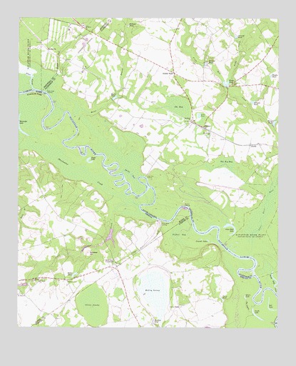
Millett, SC USGS Topographic Map
Click on map above to begin viewing in our Map Viewer.

This topographic map contains these locations and features:
Feature Name Type Latitude Longitude GNIS ID View Map
AverillPopulated PlaceN33.0743°W81.5134°1231020View Map
Billinger PondLakeN33.1235°W81.5664°1220746View Map
Boggy Gut BranchStreamN33.0946°W81.6115°1246930View Map
Brier BranchStreamN33.0852°W81.5996°1246984View Map
Browns LandingPopulated PlaceN33.0493°W81.5448°1231090View Map
Browns PondReservoirN33.1067°W81.5350°1221027View Map
Cains PondReservoirN33.0117°W81.5265°312154View Map
Cains StoreLocaleN33.0082°W81.5473°312155View Map
Cator Hall LakeLakeN33.0377°W81.5233°1221409View Map
Clubhouse RidgeRidgeN33.0946°W81.6171°312770View Map
Corinth CemeteryCemeteryN33.0188°W81.6171°347962View Map
Corinth ChurchChurchN33.0193°W81.6168°355312View Map
Devils ElbowBendN33.0607°W81.5651°1704981View Map
Dunbar School (historical)SchoolN33.1043°W81.5004°1242263View Map
Dunbar StoreLocaleN33.1029°W81.5501°1222143View Map
Duncan PondReservoirN33.1177°W81.5205°1222147View Map
Echee PondLakeN33.0859°W81.5380°1222229View Map
Furse CemeteryCemeteryN33.0985°W81.5218°1222613View Map
Furse CreekStreamN33.1002°W81.5234°1247852View Map
Furse Mill Pond Dam D-2563DamN33.0985°W81.5251°1239548View Map
Furse PondReservoirN33.0981°W81.5251°1222614View Map
HattievillePopulated PlaceN33.1124°W81.6112°1231368View Map
Hillis CornerLocaleN33.0189°W81.6011°2559143View Map
Hillis PondReservoirN33.0215°W81.5976°315430View Map
Hills StorePopulated PlaceN33.0193°W81.6009°331989View Map
Johnson PondReservoirN33.0914°W81.5124°1223614View Map
Little Hell LandingPopulated PlaceN33.0613°W81.5634°1246400View Map
Little Hell PointCapeN33.0602°W81.5637°1704982View Map
Little Sweetwater CreekStreamN33.0488°W81.5668°317214View Map
Lower Three RunsStreamN33.0293°W81.5137°1246479View Map
Martin-Millett Community CenterBuildingN33.0932°W81.5243°1233137View Map
MillettPopulated PlaceN33.0813°W81.5357°1231549View Map
Millett Church (historical)ChurchN33.1082°W81.5354°1233143View Map
Millett DivisionCivilN33.0986°W81.5254°1938350View Map
Millett-Rosenwald School (historical)SchoolN33.0996°W81.5371°1233144View Map
Millett-Rosenwald School (historical)SchoolN33.0932°W81.5243°1233145View Map
Mobley SwampSwampN33.0142°W81.5588°318369View Map
Murray PondReservoirN33.0022°W81.5595°319167View Map
Myers PondReservoirN33.0928°W81.5787°1224912View Map
Oliver SwampSwampN33.0095°W81.5890°320057View Map
Peeples PondReservoirN33.1018°W81.5040°1225348View Map
Potlikker HillSummitN33.0304°W81.5907°332744View Map
Prescott LakesReservoirN33.0355°W81.5335°321129View Map
Queen LakeLakeN33.0125°W81.5155°321247View Map
Red LakeLakeN33.0075°W81.5020°321390View Map
Rock Fence CrossroadsPopulated PlaceN33.0263°W81.5779°332878View Map
Royal LakeReservoirN33.0667°W81.5906°321979View Map
Saint Johns ChurchChurchN33.0135°W81.6223°322127View Map
Saint Marys Baptist ChurchChurchN33.0187°W81.6144°2502899View Map
Saint Marys ChurchChurchN33.1215°W81.5932°1226204View Map
Saint Marys ChurchChurchN33.0185°W81.6140°322201View Map
Saint Marys School (historical)SchoolN33.1213°W81.5934°1235534View Map
Shoemaker LakeReservoirN33.0785°W81.6225°322952View Map
Smith LakeLakeN33.0045°W81.5091°323142View Map
Smiths LakeSwampN33.0226°W81.5045°1235818View Map
Speedwell ChurchChurchN33.0840°W81.5418°1250987View Map
Steel CreekStreamN33.0965°W81.6173°1251034View Map
Steel Creek LandingPopulated PlaceN33.0952°W81.6118°1251035View Map
Stoney Bluff Ferry (historical)CrossingN33.0438°W81.5565°1235819View Map
Stoney Bluff Ferry (historical)CrossingN33.0438°W81.5565°348066View Map
Stony Bluff LandingLocaleN33.0432°W81.5554°333135View Map
Sweetwater CreekStreamN33.0488°W81.5665°323840View Map
Swift GutStreamN33.0604°W81.5673°1227001View Map
Telfair BaySwampN33.0393°W81.5482°323972View Map
Terry PondLakeN33.0829°W81.5018°1227062View Map
The BaySwampN33.0894°W81.5477°1227068View Map
The Big BaySwampN33.0651°W81.5255°1227069View Map
The LagoonLakeN33.0088°W81.5148°324048View Map
Zion Grove ChurchChurchN33.0788°W81.5329°1227761View Map

Note: Coordinates in the location and feature list above are referenced to NAD83 datum.


Copyright (C) 2008-2024 Ryan Niemi / Sunset Dynamics ... All Rights Reserved