TopoQuest Logo
Do you find TopoQuest useful?
Help keep TopoQuest running and adding new maps/features by donating!
Bitcoin:  19c7KJd3qBynnjoSw5npx9KScwjBe4ifkT
Litecoin:  LXs6TkuXGGXo1vDsWCkWVdjQX94eUKd6ui
Home View Maps Find Maps Find Places Resources & Links


Busher Canyon, Texas Topographic Map

USGS Map Title: Busher Canyon, TX
USGS Map MRC: 30102D5
DRG (GeoTIFF) Download: o30102d5.tif


Neighboring USGS Topographic Map Quads:


  Panther Tank, TX  
30102E6
 

  Rock House Draw, TX  
30102E5
 

  Hackberry Draw SW, TX  
30102E4
 

  Ebers Camp, TX  
30102D6
 

  Busher Canyon, TX  
30102D5
 

  Big Canyon Ranch NW, TX  
30102D4
 

  F C Ranch, TX  
30102C6
 

  Toms Canyon, TX  
30102C5
 

  Big Canyon Ranch SW, TX  
30102C4


Map MRC Location:

N31°
W103°
N31°
W102°
H8 H7 H6 H5 H4 H3 H2 H1
G8 G7 G6 G5 G4 G3 G2 G1
F8 F7 F6 F5 F4 F3 F2 F1
E8 E7 E6 E5 E4 E3 E2 E1
D8 D7 D6 D5 D4 D3 D2 D1
C8 C7 C6 C5 C4 C3 C2 C1
B8 B7 B6 B5 B4 B3 B2 B1
A8 A7 A6 A5 A4 A3 A2 A1
N30°
W103°
N30°
W102°

Busher Canyon, TX USGS 1:24K Topographic Map Preview:
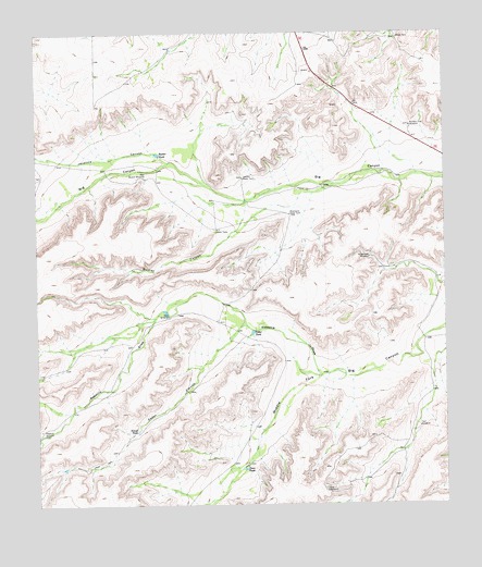
Busher Canyon, TX USGS Topographic Map
Click on map above to begin viewing in our Map Viewer.

This topographic map contains these locations and features:
Feature Name Type Latitude Longitude GNIS ID View Map
Big DivideRidgeN30.4349°W102.5635°1352058View Map
Busher CanyonValleyN30.4547°W102.5613°1353407View Map
Busher TankReservoirN30.4677°W102.5865°1353408View Map
Cedar CanyonValleyN30.4226°W102.5612°1354041View Map
Cedar TankReservoirN30.4208°W102.5594°1354152View Map
Dean TankReservoirN30.3846°W102.5620°1355790View Map
Gravel TankReservoirN30.3947°W102.5950°1358331View Map
Gray WindmillLocaleN30.3788°W102.5371°1358354View Map
Half WindmillLocaleN30.3957°W102.5085°1358649View Map
Hoodoo Water TankReservoirN30.4618°W102.5610°1359519View Map
Horseshoes WindmillLocaleN30.4407°W102.5232°1359680View Map
Javalina CanyonValleyN30.4660°W102.5843°1360169View Map
Mock WindmillLocaleN30.4252°W102.5843°1363021View Map
New Busher WindmillLocaleN30.4618°W102.5910°1363696View Map
Number Five WindmillLocaleN30.4754°W102.5104°1364238View Map
Rebecca DrawValleyN30.4096°W102.5391°1375654View Map
Rebecca WindmillLocaleN30.3952°W102.6243°1366091View Map
Whetstone Water TankReservoirN30.4524°W102.5468°1371342View Map

Note: Coordinates in the location and feature list above are referenced to NAD83 datum.


Copyright (C) 2008-2024 Ryan Niemi / Sunset Dynamics ... All Rights Reserved