TopoQuest Logo
Do you find TopoQuest useful?
Help keep TopoQuest running and adding new maps/features by donating!
Bitcoin:  19c7KJd3qBynnjoSw5npx9KScwjBe4ifkT
Litecoin:  LXs6TkuXGGXo1vDsWCkWVdjQX94eUKd6ui
Home View Maps Find Maps Find Places Resources & Links


Butte Meadows, California Topographic Map

USGS Map Title: Butte Meadows, CA
USGS Map MRC: 40121A5
DRG (GeoTIFF) Download: o40121a5.tif


Neighboring USGS Topographic Map Quads:


  Barkley Mountain, CA  
40121B6
 

  Onion Butte, CA  
40121B5
 

  Humboldt Peak, CA  
40121B4
 

  Devils Parade Ground, CA  
40121A6
 

  Butte Meadows, CA  
40121A5
 

  Jonesville, CA  
40121A4
 

  Cohasset, CA  
39121H6
 

  Stirling City, CA  
39121H5
 

  Kimshew Point, CA  
39121H4


Map MRC Location:

N41°
W122°
N41°
W121°
H8 H7 H6 H5 H4 H3 H2 H1
G8 G7 G6 G5 G4 G3 G2 G1
F8 F7 F6 F5 F4 F3 F2 F1
E8 E7 E6 E5 E4 E3 E2 E1
D8 D7 D6 D5 D4 D3 D2 D1
C8 C7 C6 C5 C4 C3 C2 C1
B8 B7 B6 B5 B4 B3 B2 B1
A8 A7 A6 A5 A4 A3 A2 A1
N40°
W122°
N40°
W121°

Butte Meadows, CA USGS 1:24K Topographic Map Preview:
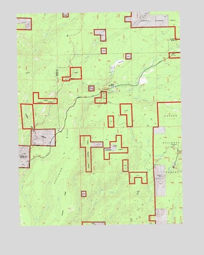
Butte Meadows, CA USGS Topographic Map
Click on map above to begin viewing in our Map Viewer.

This topographic map contains these locations and features:
Feature Name Type Latitude Longitude GNIS ID View Map
Bolt CreekStreamN40.0802°W121.5378°257330View Map
Bottle CreekStreamN40.0079°W121.5714°257370View Map
Bottle HillSummitN40.0179°W121.5339°257371View Map
Bull CreekStreamN40.0035°W121.5850°257659View Map
Bull HillSummitN40.0646°W121.5266°257664View Map
Butte County Fire Department Station 10BuildingN40.0818°W121.5341°2622325View Map
Butte MeadowsPopulated PlaceN40.0813°W121.5511°257772View Map
Butte Meadows CampgroundLocaleN40.0799°W121.5169°253261View Map
Butte Meadows Census Designated PlaceCensusN40.0872°W121.5369°2612474View Map
Butte Meadows Post Office (historical)Post OfficeN40.0813°W121.5511°1940073View Map
Butte Meadows Recreation SiteLocaleN40.0790°W121.5586°277102View Map
Camp LassenLocaleN40.0927°W121.5550°257885View Map
Carpenter RidgeRidgeN40.0490°W121.5869°257993View Map
Cascade CreekStreamN40.0877°W121.5841°258037View Map
Cedar CreekStreamN40.0024°W121.6130°258116View Map
Chaparral Guard StationLocaleN40.0382°W121.5178°258202View Map
Chico MeadowsFlatN40.0932°W121.5497°258271View Map
Coon CreekStreamN40.0352°W121.5364°258679View Map
Cornelia Lott Sank Memorial SpringSpringN40.0402°W121.5161°263451View Map
Cuddleback FlatFlatN40.0463°W121.5072°258983View Map
Department of Forestry and Fire Protection United States Forest Service Butte MeadowsBuildingN40.0791°W121.5607°2622347View Map
GlenburnPopulated PlaceN40.0615°W121.5153°1802904View Map
Hawkins CampLocaleN40.0282°W121.5166°261161View Map
Ike Dye HillSummitN40.0902°W121.6191°261684View Map
LomoPopulated PlaceN40.0385°W121.6161°262795View Map
Philbrook CreekStreamN40.0321°W121.5108°264679View Map
Secret CreekStreamN40.0032°W121.5753°265971View Map
Soda SpringsSpringN40.0867°W121.5868°253256View Map
Soda Springs CampgroundLocaleN40.0865°W121.5850°277103View Map
Soda Springs CampgroundLocaleN40.0882°W121.5830°1655195View Map
Thatcher RidgeRidgeN40.0088°W121.5911°253264View Map
West Branch CampLocaleN40.0343°W121.5078°268861View Map

Note: Coordinates in the location and feature list above are referenced to NAD83 datum.


Copyright (C) 2008-2025 Ryan Niemi / Sunset Dynamics ... All Rights Reserved