TopoQuest Logo
Do you find TopoQuest useful?
Help keep TopoQuest running and adding new maps/features by donating!
Bitcoin:  19c7KJd3qBynnjoSw5npx9KScwjBe4ifkT
Litecoin:  LXs6TkuXGGXo1vDsWCkWVdjQX94eUKd6ui
Home View Maps Find Maps Find Places Resources & Links


Cabarett Coulee, Montana Topographic Map

USGS Map Title: Cabarett Coulee, MT
USGS Map MRC: 48105F4
DRG (GeoTIFF) Download: o48105f4.tif


Neighboring USGS Topographic Map Quads:


  Four Buttes, MT  
48105G5
 

  Scobey, MT  
48105G4
 

  Madoc, MT  
48105G3
 

  South of Four Buttes, MT  
48105F5
 

  Cabarett Coulee, MT  
48105F4
 

  Line Coulee, MT  
48105F3
 

  Jakes Coulee, MT  
48105E5
 

  Nielsen Coulee, MT  
48105E4
 

  Bredette, MT  
48105E3


Map MRC Location:

N49°
W106°
N49°
W105°
H8 H7 H6 H5 H4 H3 H2 H1
G8 G7 G6 G5 G4 G3 G2 G1
F8 F7 F6 F5 F4 F3 F2 F1
E8 E7 E6 E5 E4 E3 E2 E1
D8 D7 D6 D5 D4 D3 D2 D1
C8 C7 C6 C5 C4 C3 C2 C1
B8 B7 B6 B5 B4 B3 B2 B1
A8 A7 A6 A5 A4 A3 A2 A1
N48°
W106°
N48°
W105°

Cabarett Coulee, MT USGS 1:24K Topographic Map Preview:
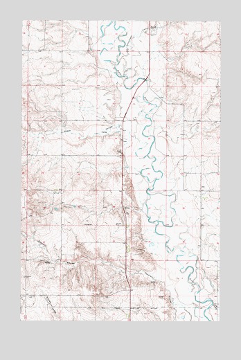
Cabarett Coulee, MT USGS Topographic Map
Click on map above to begin viewing in our Map Viewer.

This topographic map contains these locations and features:
Feature Name Type Latitude Longitude GNIS ID View Map
33N47E12AAAB01 WellWellN48.6350°W105.5000°1636081View Map
33N47E12AAAC01 WellWellN48.6345°W105.4997°1636080View Map
33N48E05DADA01 WellWellN48.6406°W105.4536°1636102View Map
33N48E06ABAC01 WellWellN48.6495°W105.4833°1636122View Map
33N48E06ABBB01 SpringSpringN48.6495°W105.4856°1636123View Map
33N48E07ACAB01 WellWellN48.6320°W105.4831°1636077View Map
33N48E07ACAB02 WellWellN48.6320°W105.4828°1636076View Map
33N48E07ACBA01 WellWellN48.6314°W105.4839°1636075View Map
34N48E03BBAA01 WellWellN48.7367°W105.4267°1636322View Map
34N48E03BBAD01 WellWellN48.7364°W105.4267°1636320View Map
34N48E03DCBB01 WellWellN48.7259°W105.4194°1636304View Map
34N48E03DCBC01 WellWellN48.7247°W105.4194°1636297View Map
34N48E03DCBC02 WellWellN48.7253°W105.4197°1636298View Map
34N48E03DCBC03 WellWellN48.7253°W105.4197°1636299View Map
34N48E07DAAD01 WellWellN48.7139°W105.4761°1636278View Map
34N48E08CCAC01 WellWellN48.7109°W105.4719°1636273View Map
34N48E08CCBA01 WellWellN48.7111°W105.4728°1636275View Map
34N48E08CCCA01 WellWellN48.7103°W105.4725°1636272View Map
34N48E11BCCD01 WellWellN48.7159°W105.4072°1636281View Map
34N48E13BACA01 WellWellN48.7064°W105.3794°1636254View Map
34N48E14ACCC01 WellWellN48.7014°W105.3975°1636243View Map
34N48E16CDCA01 WellWellN48.6950°W105.4455°1636228View Map
34N48E17BBCA01 WellWellN48.7059°W105.4731°1636251View Map
34N48E17BBCD01 WellWellN48.7056°W105.4725°1636250View Map
34N48E21ACCA01 WellWellN48.6878°W105.4408°1636208View Map
34N48E21ADBC01 WellWellN48.6895°W105.4355°1636213View Map
34N48E21ADCB01 WellWellN48.6878°W105.4355°1636207View Map
34N48E21BDDA01 WellWellN48.6875°W105.4430°1636206View Map
34N48E21DDCC01 WellWellN48.6781°W105.4364°1636183View Map
34N48E24CCCB01 WellWellN48.6759°W105.3872°1636178View Map
34N48E25BCAB01 WellWellN48.6759°W105.3855°1636177View Map
34N48E25BCBA01 WellWellN48.6759°W105.3847°1636176View Map
34N48E26BDBB01 WellWellN48.6747°W105.4030°1636170View Map
34N48E26BDBC01 WellWellN48.6742°W105.4036°1636169View Map
34N48E29BDCA01 WellWellN48.6734°W105.4681°1636165View Map
34N48E30AABA01 WellWellN48.6789°W105.4786°1636186View Map
34N48E32CDCA01 WellWellN48.6520°W105.4683°1636131View Map
34N48E33CCCD01 WellWellN48.6506°W105.4505°1636127View Map
34N48E34CADC01 WellWellN48.6545°W105.4230°1636136View Map
34N48E35ADAD01 WellWellN48.6597°W105.3883°1636142View Map
34N48E35ADAD02 WellWellN48.6600°W105.3880°1636143View Map
34N48E35DDAA01 WellWellN48.6536°W105.3880°1636133View Map
34N48E36BABA01 WellWellN48.6645°W105.3794°1636149View Map
35N48E32ACDD01 WellWellN48.7453°W105.4597°1636350View Map
35N48E32DDAC01 WellWellN48.7395°W105.4547°1636331View Map
35N48E34ACAA01 WellWellN48.7475°W105.4153°1636358View Map
35N48E34ACAD01 WellWellN48.7470°W105.4158°1636356View Map
35N48E34DDCC01 WellWellN48.7375°W105.4144°1636324View Map
35N48E34DDCC02 WellWellN48.7375°W105.4144°1636325View Map
35N48E34DDCD01 WellWellN48.7378°W105.4136°1636327View Map
Drury DamDamN48.6634°W105.4122°797815View Map
Fairview CemeteryCemeteryN48.6431°W105.4978°1637569View Map
Kraft Post Office (historical)Post OfficeN48.6284°W105.3783°1637378View Map
Line CouleeValleyN48.6317°W105.3797°773373View Map
Manternach CouleeValleyN48.7334°W105.4397°773867View Map
Negro CouleeValleyN48.7064°W105.4383°805878View Map
Silver Star HallLocaleN48.6350°W105.4950°1637575View Map

Note: Coordinates in the location and feature list above are referenced to NAD83 datum.


Copyright (C) 2008-2025 Ryan Niemi / Sunset Dynamics ... All Rights Reserved