TopoQuest Logo
Do you find TopoQuest useful?
Help keep TopoQuest running and adding new maps/features by donating!
Bitcoin:  19c7KJd3qBynnjoSw5npx9KScwjBe4ifkT
Litecoin:  LXs6TkuXGGXo1vDsWCkWVdjQX94eUKd6ui
Home View Maps Find Maps Find Places Resources & Links


Calaveras Dome, California Topographic Map

USGS Map Title: Calaveras Dome, CA
USGS Map MRC: 38120D2
DRG (GeoTIFF) Download: o38120d2.tif


Neighboring USGS Topographic Map Quads:


  Peddler Hill, CA  
38120E3
 

  Bear River Reservoir, CA  
38120E2
 

  Mokelumne Peak, CA  
38120E1
 

  Garnet Hill, CA  
38120D3
 

  Calaveras Dome, CA  
38120D2
 

  Tamarack, CA  
38120D1
 

  Dorrington, CA  
38120C3
 

  Boards Crossing, CA  
38120C2
 

  Liberty Hill, CA  
38120C1


Map MRC Location:

N39°
W121°
N39°
W120°
H8 H7 H6 H5 H4 H3 H2 H1
G8 G7 G6 G5 G4 G3 G2 G1
F8 F7 F6 F5 F4 F3 F2 F1
E8 E7 E6 E5 E4 E3 E2 E1
D8 D7 D6 D5 D4 D3 D2 D1
C8 C7 C6 C5 C4 C3 C2 C1
B8 B7 B6 B5 B4 B3 B2 B1
A8 A7 A6 A5 A4 A3 A2 A1
N38°
W121°
N38°
W120°

Calaveras Dome, CA USGS 1:24K Topographic Map Preview:
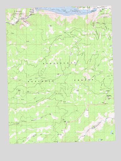
Calaveras Dome, CA USGS Topographic Map
Click on map above to begin viewing in our Map Viewer.

This topographic map contains these locations and features:
Feature Name Type Latitude Longitude GNIS ID View Map
Bellfout CanyonValleyN38.4977°W120.1366°256813View Map
Big Meadow CreekStreamN38.4221°W120.1257°266449View Map
Black SpringSpringN38.3752°W120.1927°257164View Map
Blue HoleLakeN38.4977°W120.1363°257245View Map
Cabbage PatchFlatN38.4146°W120.1321°257794View Map
Calaveras DomeCliffN38.4877°W120.2271°257820View Map
Cole CreekStreamN38.4860°W120.2402°270558View Map
Cottonwood GulchValleyN38.4385°W120.1710°258770View Map
Cuneo CampLocaleN38.4377°W120.1921°258987View Map
Deadman FlatFlatN38.4960°W120.2191°259132View Map
Department of Forestry and Fire Protection Hermit SpringBuildingN38.4255°W120.2420°2623948View Map
GannsPopulated PlaceN38.4044°W120.1591°1658598View Map
Hay GulchValleyN38.4377°W120.1644°261168View Map
Hermit SpringSpringN38.4242°W120.2390°261280View Map
Horse GulchValleyN38.4416°W120.1569°261484View Map
Lake MoranLakeN38.3829°W120.1304°263812View Map
Liberty Vista PointLocaleN38.4094°W120.1377°262435View Map
Long GulchValleyN38.4380°W120.1799°262833View Map
Mattley Cabin (historical)BuildingN38.4649°W120.1510°1675986View Map
Mattley CreekStreamN38.4960°W120.1366°263270View Map
Middle GulchValleyN38.4310°W120.1569°263540View Map
Mud SpringSpringN38.3819°W120.1885°263945View Map
Poison SpringSpringN38.3941°W120.1832°264897View Map
Pumpkin HollowBasinN38.4230°W120.1705°265063View Map
Saint Michele MeadowFlatN38.4202°W120.1332°265745View Map
Salt SpringsSpringN38.4955°W120.1399°265791View Map
Salt Springs 97-066 DamDamN38.4982°W120.2160°1663638View Map
Salt Springs ReservoirReservoirN38.4971°W120.1822°273425View Map
Shovel GraveSummitN38.4830°W120.1994°266145View Map
Swamp LakeLakeN38.3763°W120.1445°268006View Map
Tanglefoot CanyonValleyN38.4977°W120.1521°274035View Map
Water GulchValleyN38.4219°W120.1432°268805View Map

Note: Coordinates in the location and feature list above are referenced to NAD83 datum.


Copyright (C) 2008-2024 Ryan Niemi / Sunset Dynamics ... All Rights Reserved