TopoQuest Logo
Do you find TopoQuest useful?
Help keep TopoQuest running and adding new maps/features by donating!
Bitcoin:  19c7KJd3qBynnjoSw5npx9KScwjBe4ifkT
Litecoin:  LXs6TkuXGGXo1vDsWCkWVdjQX94eUKd6ui
Home View Maps Find Maps Find Places Resources & Links


Dorrington, California Topographic Map

USGS Map Title: Dorrington, CA
USGS Map MRC: 38120C3
DRG (GeoTIFF) Download: o38120c3.tif


Neighboring USGS Topographic Map Quads:


  Devils Nose, CA  
38120D4
 

  Garnet Hill, CA  
38120D3
 

  Calaveras Dome, CA  
38120D2
 

  Fort Mountain, CA  
38120C4
 

  Dorrington, CA  
38120C3
 

  Boards Crossing, CA  
38120C2
 

  Murphys, CA  
38120B4
 

  Stanislaus, CA  
38120B3
 

  Crandall Peak, CA  
38120B2


Map MRC Location:

N39°
W121°
N39°
W120°
H8 H7 H6 H5 H4 H3 H2 H1
G8 G7 G6 G5 G4 G3 G2 G1
F8 F7 F6 F5 F4 F3 F2 F1
E8 E7 E6 E5 E4 E3 E2 E1
D8 D7 D6 D5 D4 D3 D2 D1
C8 C7 C6 C5 C4 C3 C2 C1
B8 B7 B6 B5 B4 B3 B2 B1
A8 A7 A6 A5 A4 A3 A2 A1
N38°
W121°
N38°
W120°

Dorrington, CA USGS 1:24K Topographic Map Preview:
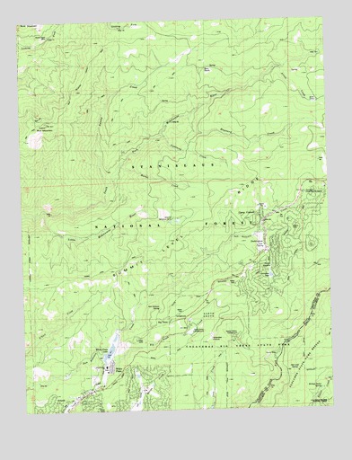
Dorrington, CA USGS Topographic Map
Click on map above to begin viewing in our Map Viewer.

This topographic map contains these locations and features:
Feature Name Type Latitude Longitude GNIS ID View Map
Airola CampLocaleN38.3549°W120.2571°266365View Map
Airola CreekStreamN38.3594°W120.2691°266366View Map
ArnoldPopulated PlaceN38.2555°W120.3510°1656296View Map
Arnold Branch Calaveras County LibraryBuildingN38.2549°W120.3546°1804828View Map
Arnold District Ranger OfficeLocaleN38.2546°W120.3546°274831View Map
Arnold Post OfficePost OfficeN38.2572°W120.3486°1804829View Map
Arnold-West Point DivisionCivilN38.3648°W120.3457°1935370View Map
Big TreesPopulated PlaceN38.2774°W120.3105°266454View Map
Big Trees Community Bible ChurchChurchN38.2583°W120.3441°1804789View Map
Big Trees CreekStreamN38.2683°W120.3416°266455View Map
Big Trees VillagePopulated PlaceN38.3096°W120.2616°1804790View Map
Bigtrees Post Office (historical)Post OfficeN38.2774°W120.3105°2026829View Map
Blue Lake JunctionPopulated PlaceN38.2585°W120.3316°1804831View Map
Blue Lake SpringsPopulated PlaceN38.2596°W120.3241°1804832View Map
Blue MountainSummitN38.3424°W120.3652°266469View Map
Blue Mountain Permanent Lookout StationLocaleN38.3421°W120.3655°274832View Map
Buck MountainSummitN38.3749°W120.3727°1656299View Map
Buck RanchLocaleN38.3588°W120.2988°1675884View Map
Buck Ranch Guard StationLocaleN38.3594°W120.2983°266497View Map
Buck Ranch Motor Wax Jeep TrailTrailN38.3655°W120.2810°266498View Map
Calaveras Big Trees State ParkParkN38.2719°W120.2877°266526View Map
Camp ConnellPopulated PlaceN38.3094°W120.2783°1656300View Map
Camp Connell Post OfficePost OfficeN38.3102°W120.2771°1804795View Map
Camp Sugar Pine Girl Scout CampLocaleN38.2966°W120.2869°1652925View Map
Cedar Center Shopping CenterLocaleN38.2549°W120.3533°1804837View Map
Cold SpringSpringN38.3012°W120.2788°1675886View Map
Dardanelles OverlookLocaleN38.2727°W120.2996°1675887View Map
DorringtonPopulated PlaceN38.3013°W120.2771°1656306View Map
Dorrington Census Designated PlaceCensusN38.2949°W120.2707°2408683View Map
Dorrington Forest Service StationLocaleN38.3194°W120.2613°1675888View Map
Dorrington Post Office (historical)Post OfficeN38.3013°W120.2771°2026828View Map
Ebbetts Pass Fire Protection District Station 1 HeadquartersBuildingN38.2576°W120.3480°2624486View Map
Ebbetts Pass Fire Protection District Station 2BuildingN38.3212°W120.2515°2624480View Map
French MeadowFlatN38.2935°W120.2760°266727View Map
Golden Torch Trailer ParkPopulated PlaceN38.2969°W120.2871°1804798View Map
Grizzly RidgePopulated PlaceN38.2563°W120.3388°1804840View Map
Hayward CreekStreamN38.3441°W120.3069°266800View Map
Hazel Fischer Elementary SchoolSchoolN38.2640°W120.3427°1675892View Map
Heckendorm MineMineN38.3705°W120.3638°1675893View Map
Independence HallBuildingN38.2627°W120.3424°1804801View Map
Lakeside TerracePopulated PlaceN38.2516°W120.3210°1804802View Map
Lightning CreekStreamN38.3385°W120.3194°1675894View Map
Lilac ParkPopulated PlaceN38.2530°W120.3496°1804843View Map
Little Mokelumne RiverStreamN38.3144°W120.3666°266921View Map
Manuel MillPopulated PlaceN38.2610°W120.3610°1656311View Map
Martel CreekStreamN38.3282°W120.3363°1675895View Map
Meadowmont Golf CourseLocaleN38.2516°W120.3594°1804844View Map
Menzies Girl Scout CampLocaleN38.3110°W120.3121°266997View Map
Million Dollar SpringSpringN38.2565°W120.2557°1675928View Map
Mountain RetreatPopulated PlaceN38.2533°W120.3269°1804845View Map
Mumbert AcresPopulated PlaceN38.2680°W120.3196°1804846View Map
North GroveWoodsN38.2813°W120.3016°267081View Map
North Grove CampgroundLocaleN38.2749°W120.3071°1675896View Map
Oak Leaf SpringSpringN38.2624°W120.2660°1675929View Map
San Antonio SpringSpringN38.2829°W120.3203°1675897View Map
Sequoia Woods Country Club and Golf CourseLocaleN38.2566°W120.3274°1804815View Map
Snowshoe LakeReservoirN38.2928°W120.2750°1675898View Map
Snowshoe SpringsPopulated PlaceN38.2916°W120.2830°1804816View Map
Squaw HollowValleyN38.2667°W120.2847°267629View Map
Squaw Hollow CampgroundLocaleN38.2730°W120.2896°1675900View Map
Summit Level RidgeRidgeN38.3038°W120.3185°267937View Map
Swamp CreekStreamN38.3227°W120.3402°267999View Map
White PinesPopulated PlaceN38.2660°W120.3408°1656408View Map
White Pines 1024-004 DamDamN38.2683°W120.3444°1664334View Map
White Pines LakeReservoirN38.2687°W120.3416°1675901View Map
White Pines ParkParkN38.2663°W120.3421°1804826View Map

Note: Coordinates in the location and feature list above are referenced to NAD83 datum.


Copyright (C) 2008-2024 Ryan Niemi / Sunset Dynamics ... All Rights Reserved