TopoQuest Logo
Do you find TopoQuest useful?
Help keep TopoQuest running and adding new maps/features by donating!
Bitcoin:  19c7KJd3qBynnjoSw5npx9KScwjBe4ifkT
Litecoin:  LXs6TkuXGGXo1vDsWCkWVdjQX94eUKd6ui
Home View Maps Find Maps Find Places Resources & Links


Cambridge, Nebraska Topographic Map

USGS Map Title: Cambridge, NE
USGS Map MRC: 40100C2
DRG (GeoTIFF) Download: o40100c2.tif


Neighboring USGS Topographic Map Quads:


  Freedom, NE  
40100D3
 

  Medicine Creek Dam, NE  
40100D2
 

  Cambridge NE, NE  
40100D1
 

  Bartley, NE  
40100C3
 

  Cambridge, NE  
40100C2
 

  Holbrook, NE  
40100C1
 

  Danbury NE, NE  
40100B3
 

  Wilsonville NW, NE  
40100B2
 

  Wilsonville NE, NE  
40100B1


Map MRC Location:

N41°
W101°
N41°
W100°
H8 H7 H6 H5 H4 H3 H2 H1
G8 G7 G6 G5 G4 G3 G2 G1
F8 F7 F6 F5 F4 F3 F2 F1
E8 E7 E6 E5 E4 E3 E2 E1
D8 D7 D6 D5 D4 D3 D2 D1
C8 C7 C6 C5 C4 C3 C2 C1
B8 B7 B6 B5 B4 B3 B2 B1
A8 A7 A6 A5 A4 A3 A2 A1
N40°
W101°
N40°
W100°

Cambridge, NE USGS 1:24K Topographic Map Preview:
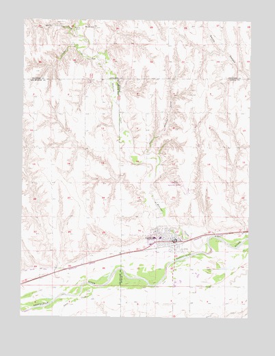
Cambridge, NE USGS Topographic Map
Click on map above to begin viewing in our Map Viewer.

This topographic map contains these locations and features:
Feature Name Type Latitude Longitude GNIS ID View Map
Butler Memorial LibraryBuildingN40.2828°W100.1671°1875651View Map
Calvary Baptist ChurchChurchN40.2847°W100.1674°1875639View Map
CambridgeLocaleN40.2803°W100.1676°1875670View Map
CambridgePopulated PlaceN40.2820°W100.1657°827874View Map
Cambridge City ParkParkN40.2861°W100.1685°1875655View Map
Cambridge City Park CampgroundLocaleN40.2861°W100.1685°1875654View Map
Cambridge Election PrecinctCivilN40.2637°W100.1382°1928766View Map
Cambridge Golf CourseLocaleN40.2820°W100.1657°1875644View Map
Cambridge Medical ClinicHospitalN40.2828°W100.1671°1875648View Map
Cambridge Memorial Hospital HeliportAirportN40.2808°W100.1793°837515View Map
Cambridge Municipal AirportAirportN40.3039°W100.1594°837514View Map
Cambridge MuseumBuildingN40.2825°W100.1679°1875650View Map
Cambridge Police DepartmentBuildingN40.2820°W100.1657°1875645View Map
Cambridge Post OfficePost OfficeN40.2834°W100.1664°1875653View Map
Cambridge Public SchoolsSchoolN40.2833°W100.1740°1875675View Map
Cambridge Rescue ServiceBuildingN40.2834°W100.1634°2553789View Map
Cambridge Volunteer Fire DepartmentBuildingN40.2834°W100.1634°1875652View Map
City of CambridgeCivilN40.2843°W100.1654°2393508View Map
Congregational ChurchChurchN40.2833°W100.1682°1875640View Map
Fairview CemeteryCemeteryN40.2850°W100.1821°829221View Map
Harding School Number 70SchoolN40.3358°W100.1751°836047View Map
Heritage Plaza Retirement VillageHospitalN40.2833°W100.1771°1875672View Map
Jones and Cope Dental ClinicHospitalN40.2828°W100.1671°1875647View Map
Joseph DamDamN40.3617°W100.1454°1769518View Map
Joseph ReservoirReservoirN40.3609°W100.1471°1769519View Map
Little Medicine CreekStreamN40.3170°W100.1832°830785View Map
Medicine CreekStreamN40.2820°W100.1482°831184View Map
Mount Zion SchoolSchoolN40.3717°W100.1524°831495View Map
Mousel SchoolSchoolN40.3720°W100.2118°831499View Map
Nebraska Urology CenterHospitalN40.2833°W100.1771°1875673View Map
North Valley SchoolSchoolN40.2845°W100.2321°831745View Map
Parkside ManorHospitalN40.2833°W100.1643°1875649View Map
Progressive Family Medical AssociatesHospitalN40.2828°W100.1671°1875646View Map
Richmond CreekStreamN40.2711°W100.1957°832550View Map
Saint John Catholic ChurchChurchN40.2833°W100.1724°1875641View Map
Saint Pauls Lutheran ChurchChurchN40.2839°W100.1754°1875642View Map
School CreekStreamN40.3586°W100.2149°833263View Map
Shelly CreekStreamN40.3678°W100.2207°833380View Map
Silver CreekStreamN40.2633°W100.2104°833432View Map
Tri - Valley Health System Cambridge Memorial HospitalHospitalN40.2810°W100.1798°1875671View Map
Tri-Valley Physical TherapyHospitalN40.2833°W100.1771°1875674View Map
United Methodist ChurchChurchN40.2828°W100.1676°1875643View Map

Note: Coordinates in the location and feature list above are referenced to NAD83 datum.


Copyright (C) 2008-2025 Ryan Niemi / Sunset Dynamics ... All Rights Reserved