TopoQuest Logo
Do you find TopoQuest useful?
Help keep TopoQuest running and adding new maps/features by donating!
Bitcoin:  19c7KJd3qBynnjoSw5npx9KScwjBe4ifkT
Litecoin:  LXs6TkuXGGXo1vDsWCkWVdjQX94eUKd6ui
Home View Maps Find Maps Find Places Resources & Links


Appleton, Tennessee Topographic Map

USGS Map Title: Appleton, TN
USGS Map MRC: 35087A2
DRG (GeoTIFF) Download: o35087a2.tif


Neighboring USGS Topographic Map Quads:


  Lawrenceburg, TN  
35087B3
 

  Bodenham, TN  
35087B2
 

  Pulaski, TN  
35087B1
 

  Bonnertown, TN  
35087A3
 

  Appleton, TN  
35087A2
 

  Aspen Hill, TN  
35087A1
 

  Lexington, AL  
34087H3
 

  Union Hill, AL  
34087H2
 

  Salem, AL  
34087H1


Map MRC Location:

N36°
W88°
N36°
W87°
H8 H7 H6 H5 H4 H3 H2 H1
G8 G7 G6 G5 G4 G3 G2 G1
F8 F7 F6 F5 F4 F3 F2 F1
E8 E7 E6 E5 E4 E3 E2 E1
D8 D7 D6 D5 D4 D3 D2 D1
C8 C7 C6 C5 C4 C3 C2 C1
B8 B7 B6 B5 B4 B3 B2 B1
A8 A7 A6 A5 A4 A3 A2 A1
N35°
W88°
N35°
W87°

Appleton, TN USGS 1:24K Topographic Map Preview:
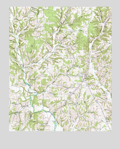
Appleton, TN USGS Topographic Map
Click on map above to begin viewing in our Map Viewer.

This topographic map contains these locations and features:
Feature Name Type Latitude Longitude GNIS ID View Map
Alsup HollowValleyN35.0323°W87.1293°1304812View Map
AppletonPopulated PlaceN35.0237°W87.2333°1275827View Map
Appleton BranchStreamN35.0195°W87.2383°113190View Map
Appleton ChurchChurchN35.0187°W87.2386°1275829View Map
Appleton School (historical)SchoolN35.0209°W87.2358°1275830View Map
Bass BranchStreamN35.0770°W87.1503°1276431View Map
Bevel SpringSpringN35.1054°W87.1361°1305190View Map
Black HollowValleyN35.0599°W87.1449°1277574View Map
Booth ChapelChurchN35.0276°W87.1764°1277991View Map
Booth Chapel CemeteryCemeteryN35.0270°W87.1772°1316257View Map
Booth HollowValleyN35.0100°W87.1698°1277992View Map
Bruce HollowValleyN35.0202°W87.1547°1278654View Map
Bullington Store (historical)LocaleN35.0029°W87.1278°1316261View Map
Campbell BranchStreamN35.0867°W87.1875°1305640View Map
Cave BranchStreamN35.1079°W87.1836°1279912View Map
City of Minor HillCivilN35.0412°W87.1700°2404274View Map
Clear CreekStreamN35.0926°W87.2386°1305952View Map
Coffman HollowValleyN35.0728°W87.1496°1280872View Map
Commissioner District 2CivilN35.0880°W87.1409°2463921View Map
Concord School (historical)SchoolN35.1129°W87.2414°1281076View Map
Crab HollowValleyN35.0567°W87.1804°1281518View Map
Dobbins CemeteryCemeteryN35.0256°W87.2261°1282533View Map
East Fork Hulsey BranchStreamN35.0148°W87.1642°1283346View Map
East Fork Shannon CreekStreamN35.0831°W87.1953°1283362View Map
East Fork Sugar CreekStreamN35.0331°W87.2239°1283370View Map
Flippo SpringSpringN35.0398°W87.1284°1310373View Map
Givens HollowValleyN35.0826°W87.1971°1285464View Map
Glover HollowValleyN35.0882°W87.1519°1285536View Map
Green SpringSpringN35.0688°W87.2200°1286126View Map
HawLocaleN35.0101°W87.1372°1287160View Map
Hood BranchStreamN35.0220°W87.2350°1288221View Map
Hood HollowValleyN35.0190°W87.2395°1646870View Map
Hulsey HollowValleyN35.0155°W87.1640°1288693View Map
Jackson CemeteryCemeteryN35.0376°W87.1311°1289188View Map
Jones HollowValleyN35.0499°W87.1400°1289796View Map
Lee HollowValleyN35.0628°W87.2350°1290958View Map
Liberty ChapelChurchN35.0029°W87.1278°1291119View Map
Liberty Hill School (historical)SchoolN35.0129°W87.1450°1291161View Map
Long BranchStreamN35.0984°W87.2358°1291866View Map
MalonePopulated PlaceN35.0629°W87.2039°1315456View Map
MarbutsPopulated PlaceN35.0273°W87.1678°1315465View Map
McGrew HollowValleyN35.1150°W87.1264°1310384View Map
Miller HollowValleyN35.0887°W87.2416°1293952View Map
Minor HillSummitN35.0545°W87.1572°1644015View Map
Minor HillPopulated PlaceN35.0554°W87.1575°1294062View Map
Minor Hill CemeteryCemeteryN35.0517°W87.1583°1644016View Map
Minor Hill Division (historical)CensusN35.0790°W87.1497°1648709View Map
Minor Hill First Baptist ChurchChurchN35.0529°W87.1578°1644017View Map
Minor Hill Police DepartmentBuildingN35.0522°W87.1590°2765900View Map
Minor Hill Post OfficePost OfficeN35.0569°W87.1571°1650381View Map
Minor Hill School (historical)SchoolN35.0534°W87.1572°1316286View Map
Minor Hill Volunteer Fire DepartmentBuildingN35.0521°W87.1591°2653904View Map
Mount Zion CemeteryCemeteryN35.0651°W87.2320°1642010View Map
Mount Zion ChurchChurchN35.0656°W87.2328°1326837View Map
New Hope BranchStreamN35.0440°W87.2459°1295508View Map
Noblit CemeteryCemeteryN35.0273°W87.2114°1295795View Map
Oxford CemeteryCemeteryN35.0059°W87.2033°1296619View Map
Parker HollowValleyN35.0828°W87.2430°1296835View Map
PeachPopulated PlaceN35.0462°W87.2242°1297042View Map
Pinhook BranchStreamN35.0254°W87.2217°1297658View Map
Pleasant Ridge CemeteryCemeteryN35.1020°W87.1633°1644029View Map
Pleasant Ridge ChurchChurchN35.1026°W87.1636°1297908View Map
Pollock HollowValleyN35.0401°W87.2034°1298073View Map
Poplar SpringSpringN35.0995°W87.1731°1298219View Map
Powell CemeteryCemeteryN35.0792°W87.2014°1298398View Map
Powell School (historical)SchoolN35.0795°W87.1956°1298425View Map
Puncheon BranchStreamN35.0359°W87.2161°1298687View Map
Puncheon ChurchChurchN35.0398°W87.2081°1298697View Map
Puncheon School (historical)SchoolN35.0390°W87.2106°1298699View Map
Rackley HollowValleyN35.1075°W87.1842°1298802View Map
Reedy BranchStreamN35.0679°W87.2222°1299162View Map
Sam Davis MonumentLocaleN35.0392°W87.1736°1300621View Map
Sawmill HollowValleyN35.0702°W87.2387°1300843View Map
SextonPopulated PlaceN35.0442°W87.2014°1315893View Map
Shannon CreekStreamN35.0629°W87.2331°1301233View Map
Sugar Spring (historical)LocaleN35.0190°W87.1972°1644043View Map
Tanyard BranchStreamN35.1248°W87.2220°1272104View Map
Thomas Store (historical)LocaleN35.0376°W87.1722°1316319View Map
Thompson CemeteryCemeteryN35.0662°W87.1695°1272513View Map
Thompson HollowValleyN35.0574°W87.1791°1272546View Map
Thorne StoreLocaleN35.0123°W87.1322°1272566View Map
Turkey BranchStreamN35.1070°W87.1847°1272992View Map
Walker HollowValleyN35.0730°W87.2228°1273622View Map
Warren BranchStreamN35.0092°W87.1956°128580View Map
Warren HollowValleyN35.0078°W87.2032°1647692View Map
Watkins SpringSpringN35.0514°W87.2209°1273911View Map
West Fork Sugar CreekStreamN35.0331°W87.2236°1304470View Map
West HollowValleyN35.1091°W87.1370°1274207View Map
White RidgeRidgeN35.0140°W87.1795°1274398View Map
Williams StoreLocaleN35.1231°W87.2208°1274716View Map
Wray BranchStreamN35.0462°W87.2000°1275145View Map
Yellow BranchStreamN35.1076°W87.1336°1275267View Map
Zion School (historical)SchoolN35.0648°W87.2320°1304737View Map

Note: Coordinates in the location and feature list above are referenced to NAD83 datum.


Copyright (C) 2008-2024 Ryan Niemi / Sunset Dynamics ... All Rights Reserved