TopoQuest Logo
Do you find TopoQuest useful?
Help keep TopoQuest running and adding new maps/features by donating!
Bitcoin:  19c7KJd3qBynnjoSw5npx9KScwjBe4ifkT
Litecoin:  LXs6TkuXGGXo1vDsWCkWVdjQX94eUKd6ui
Home View Maps Find Maps Find Places Resources & Links


Back Valley, Tennessee Topographic Map

USGS Map Title: Back Valley, TN
USGS Map MRC: 36083E3
DRG (GeoTIFF) Download: o36083e3.tif


Neighboring USGS Topographic Map Quads:


  Ewing, VA  
36083F4
 

  Rose Hill, VA  
36083F3
 

  Hubbard Springs, VA  
36083F2
 

  Coleman Gap, TN  
36083E4
 

  Back Valley, TN  
36083E3
 

  Sneedville, TN  
36083E2
 

  Howard Quarter, TN  
36083D4
 

  Swan Island, TN  
36083D3
 

  Lee Valley, TN  
36083D2


Map MRC Location:

N37°
W84°
N37°
W83°
H8 H7 H6 H5 H4 H3 H2 H1
G8 G7 G6 G5 G4 G3 G2 G1
F8 F7 F6 F5 F4 F3 F2 F1
E8 E7 E6 E5 E4 E3 E2 E1
D8 D7 D6 D5 D4 D3 D2 D1
C8 C7 C6 C5 C4 C3 C2 C1
B8 B7 B6 B5 B4 B3 B2 B1
A8 A7 A6 A5 A4 A3 A2 A1
N36°
W84°
N36°
W83°

Back Valley, TN USGS 1:24K Topographic Map Preview:
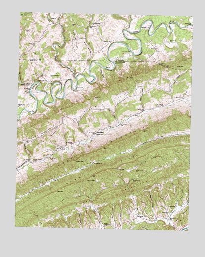
Back Valley, TN USGS Topographic Map
Click on map above to begin viewing in our Map Viewer.

This topographic map contains these locations and features:
Feature Name Type Latitude Longitude GNIS ID View Map
Back ValleyValleyN36.5251°W83.2746°1276054View Map
Back ValleyValleyN36.5631°W83.3359°1276055View Map
Baldwin FordCrossingN36.5962°W83.3057°1314622View Map
Bales FordCrossingN36.5820°W83.3332°1314623View Map
Bales GapGapN36.5765°W83.3202°1276228View Map
Barley FordCrossingN36.5945°W83.3141°1314627View Map
Bartley HollowValleyN36.5943°W83.3145°1276408View Map
Beech Grove ChurchChurchN36.6059°W83.2749°1463001View Map
Beech Grove SchoolSchoolN36.6104°W83.2666°1463003View Map
Bell GapGapN36.5212°W83.3455°1276924View Map
Big Sycamore ChurchChurchN36.5384°W83.3199°1277433View Map
Blue HollowValleyN36.5946°W83.3237°1277768View Map
Brewer ChapelChurchN36.5020°W83.3102°1278297View Map
Brewer GapGapN36.5354°W83.3024°1278299View Map
Brewer HollowValleyN36.5028°W83.2982°1278301View Map
Brier Creek ChurchChurchN36.5101°W83.2638°1278367View Map
Campbell HollowValleyN36.5071°W83.2739°1279459View Map
Camps Volunteer Fire DepartmentBuildingN36.5073°W83.2868°2654494View Map
Chestnut RidgeRidgeN36.6087°W83.3338°1464834View Map
Commissioner District 5CivilN36.5700°W83.3489°2464450View Map
Earl HollowValleyN36.5017°W83.3027°1283305View Map
EvanstonPopulated PlaceN36.5076°W83.2871°1283915View Map
Fairview ChurchChurchN36.6093°W83.3085°1466408View Map
Flea CreekStreamN36.5045°W83.2630°1284457View Map
Fletcher CliffCliffN36.6026°W83.2871°1466706View Map
Fletcher FordCrossingN36.6031°W83.2941°1492947View Map
Fourmile CreekStreamN36.5784°W83.3666°1284726View Map
Gibson GapGapN36.5387°W83.3324°1285348View Map
Jones GapGapN36.5962°W83.2610°1468843View Map
Keaton GapGapN36.5284°W83.3235°1289924View Map
Lexi CemeteryCemeteryN36.5426°W83.2524°1291100View Map
Little Mulberry ChurchChurchN36.5384°W83.3627°1291593View Map
Little Mulberry CreekStreamN36.5381°W83.3643°1291594View Map
Lowe HollowValleyN36.5841°W83.3737°1269771View Map
Mabe HollowValleyN36.5091°W83.2637°1646983View Map
Martin CreekStreamN36.5876°W83.3335°1292827View Map
Martin CreekPopulated PlaceN36.5848°W83.3541°1646984View Map
Martin Creek ChurchChurchN36.5854°W83.3549°1292831View Map
Martin Creek SchoolSchoolN36.5887°W83.3580°1292832View Map
Mathis MillBuildingN36.5140°W83.2588°1292939View Map
McDowell ShoalBarN36.5770°W83.3652°1293269View Map
Mill BranchStreamN36.5612°W83.3016°1293810View Map
Mill HollowValleyN36.5841°W83.2651°1293882View Map
Mount Davidson SchoolSchoolN36.6168°W83.3235°1470861View Map
Mountain Outlaw AirportAirportN36.5013°W83.2533°1301432View Map
Mulberry GapLocaleN36.5773°W83.2555°1295061View Map
Mulberry Gap Elementary SchoolSchoolN36.5795°W83.2541°1308264View Map
Painter BranchStreamN36.5687°W83.2838°1296671View Map
Parkey HollowValleyN36.5696°W83.2836°1646985View Map
Powell Valley Division (historical)CensusN36.5668°W83.3413°1648743View Map
RamseyPopulated PlaceN36.5445°W83.2971°1646986View Map
Ramsey SchoolSchoolN36.5443°W83.2971°1298896View Map
Rebel HollowValleyN36.5503°W83.3687°1299028View Map
Rice HollowValleyN36.5152°W83.2544°1299298View Map
Rosedale ChurchChurchN36.6218°W83.3535°1473544View Map
Sandy Springs ChurchChurchN36.5348°W83.2885°1300773View Map
Sandy Springs SchoolSchoolN36.5293°W83.2910°1300774View Map
Seal MathisPopulated PlaceN36.5062°W83.2636°2511909View Map
Seal Mathis Community CenterBuildingN36.5068°W83.2643°2511908View Map
Seal Mathis Elementary School (historical)SchoolN36.5068°W83.2643°1652457View Map
Short MountainSummitN36.5204°W83.3088°1270215View Map
Slanting MiseryCliffN36.5823°W83.3630°1270465View Map
Snake RidgeRidgeN36.5404°W83.2807°1270755View Map
Snodgrass FordCrossingN36.6201°W83.2513°1493622View Map
Speaks BranchStreamN36.6193°W83.3466°1474933View Map
SunnysidePopulated PlaceN36.5551°W83.3188°1646991View Map
Sunnyside SchoolSchoolN36.5556°W83.3185°1271867View Map
Sycamore SchoolSchoolN36.5254°W83.3546°1272007View Map
Thomas ChapelChurchN36.5551°W83.3180°1272489View Map
Thompson MillPopulated PlaceN36.5829°W83.3685°1314395View Map
Turner HollowValleyN36.5757°W83.2625°1646992View Map
Vanhuss Grove ChurchChurchN36.6195°W83.3224°1476150View Map
Wolfenbarger CemeteryCemeteryN36.5890°W83.3516°1274986View Map
Wolfenbarger ChurchChurchN36.5845°W83.3507°1304652View Map
Yellow CreekStreamN36.6162°W83.2977°1474336View Map

Note: Coordinates in the location and feature list above are referenced to NAD83 datum.


Copyright (C) 2008-2024 Ryan Niemi / Sunset Dynamics ... All Rights Reserved