TopoQuest Logo
Do you find TopoQuest useful?
Help keep TopoQuest running and adding new maps/features by donating!
Bitcoin:  19c7KJd3qBynnjoSw5npx9KScwjBe4ifkT
Litecoin:  LXs6TkuXGGXo1vDsWCkWVdjQX94eUKd6ui
Home View Maps Find Maps Find Places Resources & Links


Coleman Gap, Tennessee Topographic Map

USGS Map Title: Coleman Gap, TN
USGS Map MRC: 36083E4
DRG (GeoTIFF) Download: o36083e4.tif


Neighboring USGS Topographic Map Quads:


  Varilla, KY  
36083F5
 

  Ewing, VA  
36083F4
 

  Rose Hill, VA  
36083F3
 

  Wheeler, VA  
36083E5
 

  Coleman Gap, TN  
36083E4
 

  Back Valley, TN  
36083E3
 

  Tazewell, TN  
36083D5
 

  Howard Quarter, TN  
36083D4
 

  Swan Island, TN  
36083D3


Map MRC Location:

N37°
W84°
N37°
W83°
H8 H7 H6 H5 H4 H3 H2 H1
G8 G7 G6 G5 G4 G3 G2 G1
F8 F7 F6 F5 F4 F3 F2 F1
E8 E7 E6 E5 E4 E3 E2 E1
D8 D7 D6 D5 D4 D3 D2 D1
C8 C7 C6 C5 C4 C3 C2 C1
B8 B7 B6 B5 B4 B3 B2 B1
A8 A7 A6 A5 A4 A3 A2 A1
N36°
W84°
N36°
W83°

Coleman Gap, TN USGS 1:24K Topographic Map Preview:
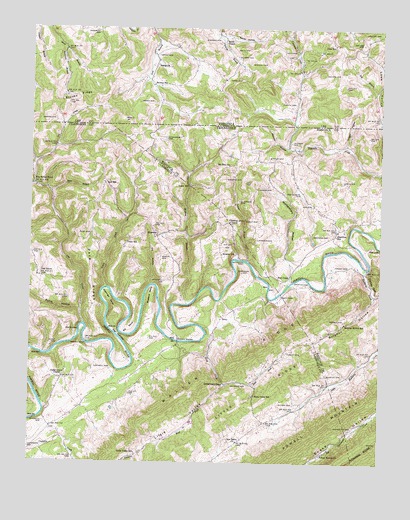
Coleman Gap, TN USGS Topographic Map
Click on map above to begin viewing in our Map Viewer.

This topographic map contains these locations and features:
Feature Name Type Latitude Longitude GNIS ID View Map
Alanthus HillPopulated PlaceN36.5654°W83.3916°1314569View Map
Alanthus Hill Volunteer Fire DepartmentBuildingN36.5682°W83.3865°2654606View Map
Alanthus School (historical)SchoolN36.5668°W83.3880°1322671View Map
Big Spring UnionLocaleN36.5801°W83.4985°1277422View Map
Big Spring Union Baptist ChurchChurchN36.5804°W83.4985°1644767View Map
Big Spring Union School (historical)SchoolN36.5795°W83.4980°1317025View Map
Breeding CemeteryCemeteryN36.5656°W83.3932°1278276View Map
Brooks BridgeBridgeN36.5351°W83.4468°1278465View Map
Brooks CemeteryCemeteryN36.5987°W83.4918°1463885View Map
Brooks CemeteryCemeteryN36.6120°W83.3896°1463886View Map
Brooks CemeteryCemeteryN36.5412°W83.3880°1278477View Map
Brooks FerryLocaleN36.5340°W83.4794°1278481View Map
Brooks RidgeRidgeN36.6056°W83.4832°1463892View Map
Browns SchoolSchoolN36.5601°W83.4321°1278631View Map
Browns SchoolSchoolN36.6087°W83.4560°1463933View Map
Buchanan CemeteryCemeteryN36.5548°W83.4246°1278780View Map
Buchanan FordCrossingN36.5587°W83.4277°1278782View Map
Burchett CemeteryCemeteryN36.5115°W83.4946°1279025View Map
Campbell CemeteryCemeteryN36.5267°W83.4710°1279443View Map
Carpenter CemeteryCemeteryN36.5104°W83.3843°1279706View Map
Cedar Grove ChurchChurchN36.5245°W83.4880°1305774View Map
Chadwell CemeteryCemeteryN36.5523°W83.4521°1280187View Map
Chadwell CemeteryCemeteryN36.6242°W83.4774°1464707View Map
Chances CemeteryCemeteryN36.6220°W83.4324°1464727View Map
Chestnut Grove ChurchChurchN36.5695°W83.4293°1305890View Map
Clarkson CemeteryCemeteryN36.5754°W83.4257°1280616View Map
Coleman GapGapN36.5226°W83.4305°1280948View Map
Coonsies CreekStreamN36.5026°W83.4988°1275390View Map
Cox CreekStreamN36.5398°W83.4805°1465364View Map
Cox CreekStreamN36.5395°W83.4807°1281505View Map
Cox ShoalsRapidsN36.5381°W83.4823°1281512View Map
Daniel HollowValleyN36.5865°W83.4984°1647382View Map
Dean SchoolSchoolN36.6206°W83.3918°1465687View Map
Dillman CemeteryCemeteryN36.6165°W83.4255°1465797View Map
Dry HollowValleyN36.5511°W83.4568°1283000View Map
Ealy CemeteryCemeteryN36.6181°W83.4063°1466083View Map
East Fork Hoop CreekStreamN36.5226°W83.4305°1283345View Map
Eastridge BendBendN36.5468°W83.4713°1283433View Map
Edd BranchStreamN36.6070°W83.3768°1466168View Map
Edd CemeteryCemeteryN36.5740°W83.3999°1283500View Map
Elk BendBendN36.5384°W83.4649°1283633View Map
Estep CemeteryCemeteryN36.6174°W83.4551°1466347View Map
Estep HollowValleyN36.5861°W83.4983°1283858View Map
Ewing ChurchChurchN36.6145°W83.4544°1466376View Map
Fugate CemeteryCemeteryN36.5320°W83.4077°1285008View Map
Fugate CemeteryCemeteryN36.6034°W83.4052°1466910View Map
Fugate FordCrossingN36.5479°W83.4118°1315088View Map
Gibson HallPopulated PlaceN36.5159°W83.4807°1647384View Map
Gibson Hall School (historical)SchoolN36.5165°W83.4802°1317047View Map
Harkins CemeteryCemeteryN36.5642°W83.4191°1286875View Map
Hoop CreekPopulated PlaceN36.5218°W83.4193°1644787View Map
Hoop CreekStreamN36.5370°W83.4368°1288240View Map
Hoop Creek Baptist ChurchChurchN36.5293°W83.4130°1644788View Map
Hoop Creek SchoolSchoolN36.5195°W83.4193°1288241View Map
HopewellPopulated PlaceN36.5651°W83.4552°1315254View Map
Hopewell Baptist ChurchChurchN36.5648°W83.4555°1644786View Map
Hopewell School (historical)SchoolN36.5654°W83.4557°1317049View Map
Hopkins CemeteryCemeteryN36.5229°W83.4230°1288331View Map
Hurst CemeteryCemeteryN36.5340°W83.4918°1288848View Map
Hurst FordCrossingN36.5337°W83.4885°1310713View Map
Keslerson BranchStreamN36.6193°W83.4882°1468972View Map
Kesterson CemeteryCemeteryN36.5040°W83.4999°1290107View Map
Lemarr CemeteryCemeteryN36.5792°W83.4157°1291012View Map
Line HollowValleyN36.5834°W83.4439°1646982View Map
Little Valley SchoolSchoolN36.5023°W83.4616°1291702View Map
Manning CemeteryCemeteryN36.5817°W83.4307°1292587View Map
Marr BranchStreamN36.5779°W83.4930°1292726View Map
Martin CemeteryCemeteryN36.5590°W83.4535°1292822View Map
Monday CemeteryCemeteryN36.5881°W83.4155°1294161View Map
Monday HollowValleyN36.5909°W83.4087°1294162View Map
Montgomery CemeteryCemeteryN36.5779°W83.4038°1294200View Map
Montgomery HollowValleyN36.5516°W83.4077°1294204View Map
Mount Zion ChurchChurchN36.5859°W83.4299°1294922View Map
Mulberry CreekStreamN36.5562°W83.3796°1295059View Map
Mullins BranchStreamN36.5454°W83.4441°1295081View Map
New Salem ChurchChurchN36.5062°W83.4255°1295645View Map
New Salem School (historical)SchoolN36.5056°W83.4252°1317063View Map
North Claiborne Volunteer Fire Department Station 2BuildingN36.5852°W83.4749°2654518View Map
Oak GrovePopulated PlaceN36.5537°W83.4974°1296060View Map
Oak Grove Baptist ChurchChurchN36.5534°W83.4974°1644802View Map
Oak Grove CemeteryCemeteryN36.5531°W83.4974°1644803View Map
Oak Grove School (historical)SchoolN36.5531°W83.4957°1317064View Map
Overton CemeteryCemeteryN36.5251°W83.3885°1296550View Map
Overton CemeteryCemeteryN36.5526°W83.4021°1296551View Map
Overton CemeteryCemeteryN36.5923°W83.4074°1296552View Map
Owen CemeteryCemeteryN36.5815°W83.3885°1296566View Map
Pace CemeteryCemeteryN36.5659°W83.4788°1296635View Map
Pace RidgeRidgeN36.5537°W83.4780°1296639View Map
Parkey CemeteryCemeteryN36.5565°W83.3866°1296841View Map
Parkey GapGapN36.5520°W83.3788°1296842View Map
Pillion CemeteryCemeteryN36.6242°W83.3810°1472315View Map
Powell MountainRidgeN36.5112°W83.3963°1303527View Map
Pump HollowValleyN36.5435°W83.4820°1298669View Map
Red HillPopulated PlaceN36.5812°W83.4738°1315793View Map
Red Hill Baptist ChurchChurchN36.5806°W83.4738°1644812View Map
Red Hill Number One School (historical)SchoolN36.5804°W83.4735°1317071View Map
RileyPopulated PlaceN36.5412°W83.4318°1315808View Map
Riley Memorial Baptist ChurchChurchN36.5415°W83.4318°1644814View Map
Riley School (historical)SchoolN36.5423°W83.4313°1317075View Map
Ritchie CemeteryCemeteryN36.5170°W83.4052°1299478View Map
Rob CampLocaleN36.5531°W83.4113°1299583View Map
Rob Camp FordCrossingN36.5520°W83.4063°1308270View Map
Rosenbalm CemeteryCemeteryN36.5934°W83.4527°1300102View Map
Rowland BendBendN36.5484°W83.4571°1300203View Map
Smith CemeteryCemeteryN36.6192°W83.4216°1474723View Map
Smith ChapelChurchN36.6215°W83.4302°1474740View Map
Smith HollowValleyN36.6222°W83.4317°1474757View Map
Stanley CemeteryCemeteryN36.6154°W83.4205°1475065View Map
Suber CemeteryCemeteryN36.5698°W83.4191°1271626View Map
Sulphur HollowValleyN36.5485°W83.3770°1271785View Map
Sulphur Hollow SchoolSchoolN36.5404°W83.3874°1271786View Map
Sutton BranchStreamN36.5579°W83.4227°1271902View Map
The NarrowsGapN36.5368°W83.4685°1272423View Map
Trigger HollowValleyN36.5914°W83.3876°1272878View Map
Wares CemeteryCemeteryN36.6040°W83.4560°1476337View Map
West Fork Hoop CreekStreamN36.5226°W83.4305°1274176View Map
Yeary CemeteryCemeteryN36.6104°W83.4243°1474330View Map
Yeary CreekStreamN36.5501°W83.4730°1275259View Map
Yeary MillPopulated PlaceN36.5798°W83.4441°1314545View Map
Yeary SchoolSchoolN36.5634°W83.4663°1275260View Map
Yellow SpringsPopulated PlaceN36.5034°W83.3943°1644831View Map
Yellow Springs ChurchChurchN36.5031°W83.3949°1304703View Map

Note: Coordinates in the location and feature list above are referenced to NAD83 datum.


Copyright (C) 2008-2024 Ryan Niemi / Sunset Dynamics ... All Rights Reserved