TopoQuest Logo
Do you find TopoQuest useful?
Help keep TopoQuest running and adding new maps/features by donating!
Bitcoin:  19c7KJd3qBynnjoSw5npx9KScwjBe4ifkT
Litecoin:  LXs6TkuXGGXo1vDsWCkWVdjQX94eUKd6ui
Home View Maps Find Maps Find Places Resources & Links


Ball Ground West, Georgia Topographic Map

USGS Map Title: Ball Ground West, GA
USGS Map MRC: 34084C4
DRG (GeoTIFF) Download: o34084c4.tif


Neighboring USGS Topographic Map Quads:


  Ludville, GA  
34084D5
 

  Jasper, GA  
34084D4
 

  Nelson, GA  
34084D3
 

  Waleska, GA  
34084C5
 

  Ball Ground West, GA  
34084C4
 

  Ball Ground East, GA  
34084C3
 

  South Canton, GA  
34084B5
 

  Canton, GA  
34084B4
 

  Birmingham, GA  
34084B3


Map MRC Location:

N35°
W85°
N35°
W84°
H8 H7 H6 H5 H4 H3 H2 H1
G8 G7 G6 G5 G4 G3 G2 G1
F8 F7 F6 F5 F4 F3 F2 F1
E8 E7 E6 E5 E4 E3 E2 E1
D8 D7 D6 D5 D4 D3 D2 D1
C8 C7 C6 C5 C4 C3 C2 C1
B8 B7 B6 B5 B4 B3 B2 B1
A8 A7 A6 A5 A4 A3 A2 A1
N34°
W85°
N34°
W84°

Ball Ground West, GA USGS 1:24K Topographic Map Preview:
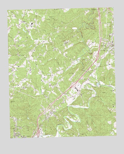
Ball Ground West, GA USGS Topographic Map
Click on map above to begin viewing in our Map Viewer.

This topographic map contains these locations and features:
Feature Name Type Latitude Longitude GNIS ID View Map
Ball GroundPopulated PlaceN34.3381°W84.3766°354443View Map
Ball Ground Baptist CemeteryCemeteryN34.3420°W84.3780°1730648View Map
Ball Ground Baptist ChurchChurchN34.3415°W84.3777°1685693View Map
Ball Ground City CemeteryCemeteryN34.3420°W84.3758°1730649View Map
Ball Ground DivisionCivilN34.3415°W84.3770°1936099View Map
Ball Ground Elementary SchoolSchoolN34.3411°W84.3770°1685694View Map
Ball Ground Methodist ChurchChurchN34.3404°W84.3763°1685695View Map
Ball Ground Police DepartmentBuildingN34.3352°W84.3789°2733830View Map
Ball Ground Post OfficePost OfficeN34.3381°W84.3771°1705283View Map
Bethel Tabernacle ChurchChurchN34.3573°W84.4988°333808View Map
Bluff CreekStreamN34.3537°W84.4258°311570View Map
Bunche SchoolSchoolN34.2598°W84.4885°312033View Map
Burris CrossroadsPopulated PlaceN34.3301°W84.4874°331290View Map
Canton Mills LakeReservoirN34.2777°W84.4778°335947View Map
Canton Mills Lake DamDamN34.2684°W84.4766°335946View Map
Chalcedonia ChurchChurchN34.2693°W84.4552°312538View Map
Cherokee County AirportAirportN34.3100°W84.4234°351704View Map
Cherokee County Fire Department Station 9 - North CanyonBuildingN34.2628°W84.4939°2603916View Map
Church of GodChurchN34.3601°W84.3788°1685727View Map
Clayton ChurchChurchN34.3329°W84.4883°1685729View Map
Clayton Community Volunteer Fire Department Station 6BuildingN34.3274°W84.4892°2603688View Map
Clayton Elementary SchoolSchoolN34.3323°W84.4894°351622View Map
Dowda CemeteryCemeteryN34.2833°W84.4380°1685736View Map
Edward CreekStreamN34.2770°W84.4130°313859View Map
Fairview ChurchChurchN34.3693°W84.3813°314053View Map
Ford LakeReservoirN34.3396°W84.4588°339981View Map
Ford Lake DamDamN34.3418°W84.4583°339980View Map
GoberPopulated PlaceN34.3056°W84.4071°331833View Map
Hickory Log CemeteryCemeteryN34.2604°W84.4810°333806View Map
Hickory Log ChurchChurchN34.2615°W84.4930°315370View Map
Hickory Log CreekStreamN34.2515°W84.4658°315371View Map
Hopewell Baptist ChurchChurchN34.3281°W84.4646°315663View Map
Keith CemeteryCemeteryN34.2584°W84.4649°1685762View Map
KeithsburgPopulated PlaceN34.2745°W84.4516°326352View Map
Lays SchoolSchoolN34.3101°W84.4230°1685771View Map
McFarland CemeteryCemeteryN34.2981°W84.4821°1685778View Map
Moore LakeReservoirN34.3698°W84.4818°335905View Map
Mount Calvary ChurchChurchN34.2918°W84.4346°318587View Map
Murphy CreekStreamN34.3218°W84.4169°319160View Map
Northside ChurchChurchN34.2670°W84.4938°1685786View Map
Northstar at L R Tippens Education CenterSchoolN34.2505°W84.4842°2545962View Map
Old Damascus ChurchChurchN34.3673°W84.4499°319965View Map
Payne-Smith LakeReservoirN34.3391°W84.4736°335907View Map
Pegasus Run Airport (historical)AirportN34.2673°W84.4219°351683View Map
Pilgrim ChurchChurchN34.3356°W84.4458°1685793View Map
Ralph Bunche CenterSchoolN34.2600°W84.4889°2346434View Map
Riggin CreekStreamN34.2893°W84.3980°321604View Map
Riverdale School (historical)SchoolN34.3520°W84.4458°1685798View Map
Sharp Mountain Baptist ChurchChurchN34.3145°W84.3988°322795View Map
Sharp Mountain CreekStreamN34.3020°W84.3933°322796View Map
Sharp Mountain Creek Structure Number Five DamDamN34.3534°W84.4783°335902View Map
Sharp Mountain Creek Structure Number Seven DamDamN34.3401°W84.4733°335906View Map
Sharp Mountain Creek Structure Number Six DamDamN34.3684°W84.4816°335904View Map
Sharp TopPopulated PlaceN34.3631°W84.4830°333016View Map
Shoal Creek ChurchChurchN34.3529°W84.4855°322944View Map
Soap CreekStreamN34.3543°W84.4171°323206View Map
Souls Harbor ChurchChurchN34.2815°W84.4408°333809View Map
Tippens SchoolSchoolN34.2507°W84.4852°333810View Map
Turner LakeReservoirN34.3544°W84.4803°335903View Map
WCHK-AM (Canton)TowerN34.2523°W84.4635°352384View Map
Welcome Valley ChurchChurchN34.3326°W84.3852°324986View Map
Zion TempleChurchN34.2629°W84.4944°333807View Map

Note: Coordinates in the location and feature list above are referenced to NAD83 datum.


Copyright (C) 2008-2025 Ryan Niemi / Sunset Dynamics ... All Rights Reserved