TopoQuest Logo
Do you find TopoQuest useful?
Help keep TopoQuest running and adding new maps/features by donating!
Bitcoin:  19c7KJd3qBynnjoSw5npx9KScwjBe4ifkT
Litecoin:  LXs6TkuXGGXo1vDsWCkWVdjQX94eUKd6ui
Home View Maps Find Maps Find Places Resources & Links


Waleska, Georgia Topographic Map

USGS Map Title: Waleska, GA
USGS Map MRC: 34084C5
DRG (GeoTIFF) Download: o34084c5.tif


Neighboring USGS Topographic Map Quads:


  Fairmount, GA  
34084D6
 

  Ludville, GA  
34084D5
 

  Jasper, GA  
34084D4
 

  White East, GA  
34084C6
 

  Waleska, GA  
34084C5
 

  Ball Ground West, GA  
34084C4
 

  Allatoona Dam, GA  
34084B6
 

  South Canton, GA  
34084B5
 

  Canton, GA  
34084B4


Map MRC Location:

N35°
W85°
N35°
W84°
H8 H7 H6 H5 H4 H3 H2 H1
G8 G7 G6 G5 G4 G3 G2 G1
F8 F7 F6 F5 F4 F3 F2 F1
E8 E7 E6 E5 E4 E3 E2 E1
D8 D7 D6 D5 D4 D3 D2 D1
C8 C7 C6 C5 C4 C3 C2 C1
B8 B7 B6 B5 B4 B3 B2 B1
A8 A7 A6 A5 A4 A3 A2 A1
N34°
W85°
N34°
W84°

Waleska, GA USGS 1:24K Topographic Map Preview:
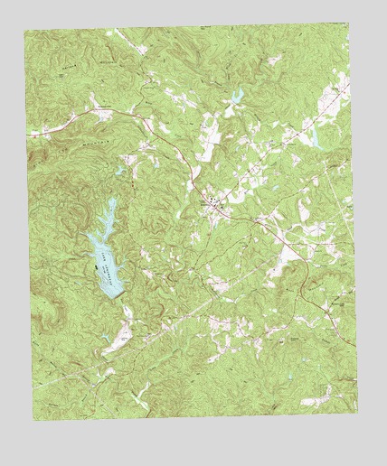
Waleska, GA USGS Topographic Map
Click on map above to begin viewing in our Map Viewer.

This topographic map contains these locations and features:
Feature Name Type Latitude Longitude GNIS ID View Map
Beasley GapPopulated PlaceN34.3490°W84.5972°331114View Map
Brier Patch ChurchChurchN34.3126°W84.5374°311794View Map
Byrd CreekStreamN34.3015°W84.5272°312133View Map
Byrd MountainSummitN34.2879°W84.5177°331302View Map
Cagle CreekStreamN34.2895°W84.5394°1947613View Map
Cherokee County Fire and Emergency Services Station 12BuildingN34.3157°W84.5547°2603710View Map
Cherokee County Fire Department Station 2BuildingN34.3268°W84.5909°2604150View Map
Cherokee County Sheriff's Office Waleska PrecinctBuildingN34.3157°W84.5547°2733490View Map
Chickasaw LakeReservoirN34.3295°W84.5894°339956View Map
Chickasaw Lake DamDamN34.3284°W84.5916°339955View Map
City of WaleskaCivilN34.3170°W84.5505°2405662View Map
Cline LakeReservoirN34.3512°W84.5431°335909View Map
Dry Pond MountainSummitN34.3748°W84.5563°331591View Map
Garland MountainSummitN34.3634°W84.5977°331793View Map
Garland Mountain School (historical)SchoolN34.3631°W84.6180°1685747View Map
Gorman BranchStreamN34.2620°W84.5988°314725View Map
Hickory Log MountainSummitN34.2848°W84.5027°331962View Map
Lake ArrowheadReservoirN34.3018°W84.5949°310637View Map
Lake Arrowhead DamDamN34.2895°W84.5908°339729View Map
Lake Arrowhead Volunteer Fire DepartmentBuildingN34.3050°W84.6081°2603767View Map
Laurel BranchStreamN34.3554°W84.5460°316667View Map
Little CreekStreamN34.2562°W84.5838°317015View Map
Lost Town CreekStreamN34.2820°W84.5872°317417View Map
McCanless CreekStreamN34.2920°W84.5672°317854View Map
McCory CreekStreamN34.3470°W84.5469°317875View Map
Moore Airstrip (historical)AirportN34.2759°W84.5905°1685779View Map
Moore CreekStreamN34.3237°W84.5627°318439View Map
Moore SchoolSchoolN34.3168°W84.5497°318443View Map
Moores Mill BridgeBridgeN34.2634°W84.5955°1685780View Map
Mount Zion ChurchChurchN34.3370°W84.5310°319037View Map
New Friendship ChurchChurchN34.3362°W84.5266°319321View Map
Olive Vine ChurchChurchN34.3045°W84.5408°320052View Map
Pittman LakeReservoirN34.3373°W84.5133°335911View Map
Pleasant Arbor ChurchChurchN34.3559°W84.5741°320788View Map
Pleasant Union ChurchChurchN34.3745°W84.5010°320930View Map
Polecat MountainSummitN34.2743°W84.5252°332719View Map
R M Moore Elementary SchoolSchoolN34.3391°W84.5293°2545866View Map
Refuge ChurchChurchN34.2962°W84.5769°321490View Map
Reinhardt CollegeSchoolN34.3187°W84.5544°321518View Map
Rock House CreekStreamN34.3540°W84.5441°321741View Map
Rocky Bottom BranchStreamN34.2609°W84.6008°321782View Map
Sardis Baptist ChurchChurchN34.3020°W84.5149°322555View Map
Sardis CreekStreamN34.3012°W84.5269°322561View Map
Schoolhouse CreekStreamN34.3259°W84.5610°322632View Map
Shoal Creek Baptist ChurchChurchN34.2765°W84.5794°322943View Map
Shut-in CreekStreamN34.3026°W84.6044°322968View Map
Stamp Shoal Creek Structure Number One DamDamN34.3501°W84.5449°335908View Map
Stamp Shoal Creek Structure Number Two DamDamN34.3368°W84.5149°335910View Map
WaleskaPopulated PlaceN34.3165°W84.5522°333342View Map
Waleska ChurchChurchN34.3529°W84.5041°324759View Map
Waleska DivisionCivilN34.3273°W84.5841°1936623View Map
Wiley CreekStreamN34.3315°W84.5580°325298View Map

Note: Coordinates in the location and feature list above are referenced to NAD83 datum.


Copyright (C) 2008-2024 Ryan Niemi / Sunset Dynamics ... All Rights Reserved