TopoQuest Logo
Do you find TopoQuest useful?
Help keep TopoQuest running and adding new maps/features by donating!
Bitcoin:  19c7KJd3qBynnjoSw5npx9KScwjBe4ifkT
Litecoin:  LXs6TkuXGGXo1vDsWCkWVdjQX94eUKd6ui
Home View Maps Find Maps Find Places Resources & Links


Bee Cave, Texas Topographic Map

USGS Map Title: Bee Cave, TX
USGS Map MRC: 30097C8
DRG (GeoTIFF) Download: o30097c8.tif


Neighboring USGS Topographic Map Quads:


  Pace Bend, TX  
30098D1
 

  Mansfield Dam, TX  
30097D8
 

  Jollyville, TX  
30097D7
 

  Shingle Hills, TX  
30098C1
 

  Bee Cave, TX  
30097C8
 

  Austin West, TX  
30097C7
 

  Dripping Springs, TX  
30098B1
 

  Signal Hill, TX  
30097B8
 

  Oak Hill, TX  
30097B7


Map MRC Location:

N31°
W98°
N31°
W97°
H8 H7 H6 H5 H4 H3 H2 H1
G8 G7 G6 G5 G4 G3 G2 G1
F8 F7 F6 F5 F4 F3 F2 F1
E8 E7 E6 E5 E4 E3 E2 E1
D8 D7 D6 D5 D4 D3 D2 D1
C8 C7 C6 C5 C4 C3 C2 C1
B8 B7 B6 B5 B4 B3 B2 B1
A8 A7 A6 A5 A4 A3 A2 A1
N30°
W98°
N30°
W97°

Bee Cave, TX USGS 1:24K Topographic Map Preview:
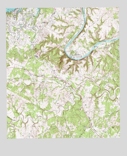
Bee Cave, TX USGS Topographic Map
Click on map above to begin viewing in our Map Viewer.

This topographic map contains these locations and features:
Feature Name Type Latitude Longitude GNIS ID View Map
Austin - Travis County Emergency Medical Service - Medic 09BuildingN30.3591°W97.9787°2655803View Map
Austin Fire Department Station 37BuildingN30.2507°W97.8946°2552516View Map
Bee CavePopulated PlaceN30.3085°W97.9450°1330313View Map
Bee Caves Baptist ChurchChurchN30.3099°W97.9639°2024595View Map
Bohls HollowValleyN30.3250°W97.9207°1331019View Map
Buck HollowValleyN30.2769°W97.9568°1331495View Map
Canyon SpringSpringN30.2600°W97.8843°1332124View Map
Cavalier Stadium at Lake TravisParkN30.3233°W97.9706°2027966View Map
Cedar HollowValleyN30.3307°W97.9344°1332454View Map
Central Texas MissionsChurchN30.3171°W97.9497°2360867View Map
Chalk KnobSummitN30.2916°W97.9920°1332617View Map
Chalk Knob HollowValleyN30.2723°W97.9862°1332618View Map
City of Bee CaveCivilN30.3093°W97.9633°2413532View Map
City of LakewayCivilN30.3558°W97.9806°2411612View Map
Darter CemeteryCemeteryN30.3635°W97.9242°1334055View Map
Dittmar HillSummitN30.2780°W97.9175°1334392View Map
Emmaus Catholic ChurchChurchN30.3563°W97.9783°2024553View Map
First Church of Christ ScientistChurchN30.3145°W97.9480°2360921View Map
Flint Rock HillSummitN30.3269°W97.9753°1335962View Map
Grape CreekStreamN30.2758°W97.9447°1336827View Map
Hamilton Pool Nature TrailTrailN30.3624°W97.9786°2033505View Map
Harrison HollowValleyN30.3541°W97.9177°1337409View Map
Hebbingston HollowValleyN30.2990°W97.8762°1337544View Map
Hickson HollowValleyN30.3044°W97.9839°1337687View Map
Holman HollowValleyN30.2677°W97.9945°1337972View Map
Honey CreekStreamN30.3366°W97.9342°1338013View Map
Hudson Bend Middle SchoolSchoolN30.3189°W97.9507°2361108View Map
Hurst CreekStreamN30.3674°W97.9667°1338326View Map
Iranian Christian Church of the Central United StatesChurchN30.3100°W97.9174°2360534View Map
Lake Hills Congregational ChurchChurchN30.2580°W97.9045°2360545View Map
Lake Pointe Elementary SchoolSchoolN30.3189°W97.9507°2361112View Map
Lake Travis Community LibraryBuildingN30.3189°W97.9507°2360752View Map
Lake Travis Elementary SchoolSchoolN30.3705°W97.9450°2009136View Map
Lake Travis High SchoolSchoolN30.3274°W97.9700°2009137View Map
Lake Travis Middle SchoolSchoolN30.3210°W97.9539°2009138View Map
Lake Travis Middle SchoolSchoolN30.3280°W97.9669°78738View Map
Lake Travis Post OfficePost OfficeN30.3432°W97.9686°2361076View Map
Lakeland ParkParkN30.3285°W97.9258°1339533View Map
LakewayPopulated PlaceN30.3680°W97.9917°1339552View Map
Lakeway AirparkAirportN30.3576°W97.9945°1386187View Map
Lakeway City HallBuildingN30.3642°W97.9811°2753555View Map
Lakeway Elementary SchoolSchoolN30.3529°W97.9760°2009139View Map
Lakeway Police DepartmentBuildingN30.3622°W97.9799°2739176View Map
Limekiln BranchStreamN30.3049°W97.9667°1339931View Map
Little Barton CreekStreamN30.2955°W97.9267°1340011View Map
Lohmans Crossing Shopping CenterLocaleN30.3426°W97.9678°2361033View Map
Long BranchStreamN30.2613°W97.9928°1340432View Map
Mary Quinlan ParkParkN30.3274°W97.9236°2029827View Map
Maul HillSummitN30.3358°W97.9689°1341082View Map
Myrtle CreekStreamN30.2635°W97.9472°1342342View Map
Owl HollowValleyN30.3041°W97.9622°1343382View Map
Panorama RanchLocaleN30.3419°W97.8808°1343516View Map
Pecan Grove TrailTrailN30.3377°W97.8936°2033269View Map
Roberts CemeteryCemeteryN30.3005°W97.8906°1345314View Map
Rocky CreekStreamN30.2652°W97.9958°1345465View Map
Round MountainSummitN30.3610°W97.9556°1345677View Map
Saint Andrews Episcopal Upper School Football FieldParkN30.2627°W97.8917°2027646View Map
Saint Christophers Episcopal ChurchChurchN30.2580°W97.8886°2024477View Map
Santa Monica SpringsSpringN30.3585°W97.9086°1998314View Map
Selma Hughes ParkParkN30.3383°W97.9042°2029398View Map
Shield RanchLocaleN30.2694°W97.9928°1347037View Map
Spillman HollowValleyN30.3021°W97.9792°1347656View Map
The Church of Jesus Christ of Latter Day SaintsChurchN30.3086°W97.8997°2360632View Map
The HillsPopulated PlaceN30.3480°W97.9850°1785535View Map
The Hills Village OfficesBuildingN30.3496°W97.9953°2753985View Map
Thomas SpringsSpringN30.2558°W97.9253°1998319View Map
Thomas Springs BranchStreamN30.2771°W97.9328°1348490View Map
Trading PostLocaleN30.3049°W97.9358°1384221View Map
Travis County Constable's Office Precinct 3BuildingN30.2514°W97.8937°2739528View Map
Travis County Emergency Services District 3 Station 2 Oak HillBuildingN30.2790°W97.8832°2552569View Map
Travis County Emergency Services District 6 Station 2 LakewayBuildingN30.3591°W97.9788°2552527View Map
Travis County Emergency Services District 6 Station 3 Bee CaveBuildingN30.3072°W97.9469°2552526View Map
Travis County Emergency Services District 6 Station 5 Steiner RanchBuildingN30.3701°W97.8944°2552533View Map
Village of The HillsCivilN30.3464°W97.9864°2413592View Map
Waterfall TrailTrailN30.3377°W97.8936°2033089View Map
West Ridge Middle SchoolSchoolN30.3033°W97.8844°2009090View Map
White BranchStreamN30.2646°W97.9695°1349931View Map
White Rock CemeteryCemeteryN30.3099°W97.9625°1349982View Map
Yaupon CreekStreamN30.3635°W97.9686°1350656View Map

Note: Coordinates in the location and feature list above are referenced to NAD83 datum.


Copyright (C) 2008-2024 Ryan Niemi / Sunset Dynamics ... All Rights Reserved