TopoQuest Logo
Do you find TopoQuest useful?
Help keep TopoQuest running and adding new maps/features by donating!
Bitcoin:  19c7KJd3qBynnjoSw5npx9KScwjBe4ifkT
Litecoin:  LXs6TkuXGGXo1vDsWCkWVdjQX94eUKd6ui
Home View Maps Find Maps Find Places Resources & Links


Signal Hill, Texas Topographic Map

USGS Map Title: Signal Hill, TX
USGS Map MRC: 30097B8
DRG (GeoTIFF) Download: o30097b8.tif


Neighboring USGS Topographic Map Quads:


  Shingle Hills, TX  
30098C1
 

  Bee Cave, TX  
30097C8
 

  Austin West, TX  
30097C7
 

  Dripping Springs, TX  
30098B1
 

  Signal Hill, TX  
30097B8
 

  Oak Hill, TX  
30097B7
 

  Driftwood, TX  
30098A1
 

  Mountain City, TX  
30097A8
 

  Buda, TX  
30097A7


Map MRC Location:

N31°
W98°
N31°
W97°
H8 H7 H6 H5 H4 H3 H2 H1
G8 G7 G6 G5 G4 G3 G2 G1
F8 F7 F6 F5 F4 F3 F2 F1
E8 E7 E6 E5 E4 E3 E2 E1
D8 D7 D6 D5 D4 D3 D2 D1
C8 C7 C6 C5 C4 C3 C2 C1
B8 B7 B6 B5 B4 B3 B2 B1
A8 A7 A6 A5 A4 A3 A2 A1
N30°
W98°
N30°
W97°

Signal Hill, TX USGS 1:24K Topographic Map Preview:
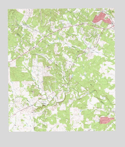
Signal Hill, TX USGS Topographic Map
Click on map above to begin viewing in our Map Viewer.

This topographic map contains these locations and features:
Feature Name Type Latitude Longitude GNIS ID View Map
Austin / Travis County Emergency Medical Service - Medic 31BuildingN30.1829°W97.8976°2656226View Map
Austin Fire Department Station 43BuildingN30.1829°W97.8975°2552525View Map
Bear CreekPopulated PlaceN30.1891°W97.9447°1802731View Map
Cedar ValleyPopulated PlaceN30.2224°W97.9558°1373030View Map
Circle C Slaughter Creek TrailTrailN30.2038°W97.8939°2032887View Map
Driftwood Volunteer Fire DepartmentBuildingN30.1515°W97.9757°2552184View Map
Fellowship of the Hills ChurchChurchN30.2319°W97.9286°2024427View Map
First Baptist Church of Oak HillChurchN30.2297°W97.8784°2360920View Map
Fitzhugh Baptist ChurchChurchN30.2302°W97.9725°2024611View Map
Friday MountainSummitN30.1519°W97.9600°1336214View Map
Friendship ChurchChurchN30.1591°W97.9545°1336228View Map
Gorzycki Middle SchoolSchoolN30.2144°W97.8921°2361126View Map
Heissner RanchLocaleN30.2172°W97.9092°1337568View Map
Hill Country Baptist Church of OakhillChurchN30.2374°W97.8786°2024569View Map
Hill Country Baptist Church of OakhillChurchN30.2375°W97.8785°2360518View Map
Joe Dan Mills Elementary SchoolSchoolN30.2124°W97.8770°2009126View Map
Johnny Voudouris HeliportAirportN30.2327°W97.9150°1387256View Map
Johnson CemeteryCemeteryN30.1563°W97.9583°1338779View Map
Kiker Elementary SchoolSchoolN30.1938°W97.8928°2009131View Map
Koenig RanchLocaleN30.1888°W97.9353°1339211View Map
Majestic Mountain MinistriesChurchN30.1860°W97.8923°2360552View Map
Manchaca Volunteer Fire Department Station 6BuildingN30.1362°W97.8937°2552659View Map
Mills Elementary SchoolSchoolN30.2119°W97.8765°2361114View Map
Mount Olive Lutheran Church PreschoolSchoolN30.2387°W97.8792°2361115View Map
Oak Hill Assembly of God ChurchChurchN30.2488°W97.8906°2024589View Map
Oliver CemeteryCemeteryN30.2322°W97.9431°1343256View Map
Rim Rock TrailTrailN30.2074°W97.9503°1345217View Map
Sawyer RanchLocaleN30.1716°W97.9992°1346742View Map
Scenic Hills Baptist ChurchChurchN30.2360°W97.9108°2024536View Map
Seton Southwest Healthcare CenterHospitalN30.2266°W97.8921°2718984View Map
Signal HillSummitN30.1902°W97.9545°1347114View Map
Signal Hill RanchLocaleN30.1888°W97.9653°1347115View Map
Spillar RanchLocaleN30.1619°W97.9067°1347653View Map
Spring HollowValleyN30.1561°W97.9516°1347743View Map
Travis County Emergency Services District 3 Station 1 Oak HillBuildingN30.2395°W97.9199°2552343View Map
Village of Bear CreekCivilN30.1826°W97.9400°2413531View Map

Note: Coordinates in the location and feature list above are referenced to NAD83 datum.


Copyright (C) 2008-2025 Ryan Niemi / Sunset Dynamics ... All Rights Reserved