TopoQuest Logo
Do you find TopoQuest useful?
Help keep TopoQuest running and adding new maps/features by donating!
Bitcoin:  19c7KJd3qBynnjoSw5npx9KScwjBe4ifkT
Litecoin:  LXs6TkuXGGXo1vDsWCkWVdjQX94eUKd6ui
Home View Maps Find Maps Find Places Resources & Links


Beverly East, West Virginia Topographic Map

USGS Map Title: Beverly East, WV
USGS Map MRC: 38079G7
DRG (GeoTIFF) Download: o38079g7.tif


Neighboring USGS Topographic Map Quads:


  Junior, WV  
38079H8
 

  Elkins, WV  
38079H7
 

  Bowden, WV  
38079H6
 

  Beverly West, WV  
38079G8
 

  Beverly East, WV  
38079G7
 

  Glady, WV  
38079G6
 

  Mill Creek, WV  
38079F8
 

  Wildell, WV  
38079F7
 

  Sinks of Gandy, WV  
38079F6


Map MRC Location:

N39°
W80°
N39°
W79°
H8 H7 H6 H5 H4 H3 H2 H1
G8 G7 G6 G5 G4 G3 G2 G1
F8 F7 F6 F5 F4 F3 F2 F1
E8 E7 E6 E5 E4 E3 E2 E1
D8 D7 D6 D5 D4 D3 D2 D1
C8 C7 C6 C5 C4 C3 C2 C1
B8 B7 B6 B5 B4 B3 B2 B1
A8 A7 A6 A5 A4 A3 A2 A1
N38°
W80°
N38°
W79°

Beverly East, WV USGS 1:24K Topographic Map Preview:
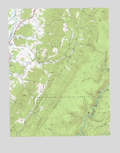
Beverly East, WV USGS Topographic Map
Click on map above to begin viewing in our Map Viewer.

This topographic map contains these locations and features:
Feature Name Type Latitude Longitude GNIS ID View Map
Abundant Life Christian AcademySchoolN38.8439°W79.8736°2088106View Map
Beaver CreekStreamN38.8651°W79.8706°1550217View Map
BeulahPopulated PlaceN38.7512°W79.7578°1553878View Map
Beverly CemeteryCemeteryN38.8459°W79.8734°1727131View Map
Beverly DistrictCivilN38.8523°W79.8227°1928166View Map
Beverly Elementary SchoolSchoolN38.8433°W79.8722°1727132View Map
Beverly Post OfficePost OfficeN38.8401°W79.8712°1727134View Map
Beverly Volunteer Fire DepartmentBuildingN38.8441°W79.8718°2577651View Map
Camp PioneerLocaleN38.8201°W79.8523°1550609View Map
Carrick RunStreamN38.8057°W79.8590°1550641View Map
Cheat JunctionPopulated PlaceN38.7948°W79.7545°1554116View Map
Chenoweth KnobSummitN38.8712°W79.7581°1550680View Map
Childers KnobSummitN38.8259°W79.8351°1554130View Map
Cucumber RidgeRidgeN38.8326°W79.8020°1550856View Map
Deer LickStreamN38.7618°W79.7815°1550902View Map
Dodson RunStreamN38.8532°W79.8709°1550934View Map
Elk River JunctionPopulated PlaceN38.7918°W79.7612°1554385View Map
Elkhorn School (historical)SchoolN38.8343°W79.7951°1727151View Map
Elks Golf CourseLocaleN38.8671°W79.8617°2634078View Map
Elliott RidgeRidgeN38.8440°W79.8084°1551053View Map
Fall RunStreamN38.7723°W79.7781°1551088View Map
Files RunStreamN38.8348°W79.7951°1551104View Map
Greenbrier JunctionPopulated PlaceN38.7801°W79.7653°1554607View Map
Harper KnobSummitN38.7901°W79.8581°1551368View Map
Hawflat KnobSummitN38.8623°W79.7634°1554664View Map
HazelwoodPopulated PlaceN38.8615°W79.8598°1554671View Map
Hazelwood School (historical)SchoolN38.8618°W79.8601°1727170View Map
High FallsFallsN38.7725°W79.7773°1551426View Map
Hill RunStreamN38.8348°W79.7951°1551442View Map
Hoe Lick RunStreamN38.8262°W79.8020°1551461View Map
Imboden KnobSummitN38.8198°W79.8742°1554763View Map
Kings RunStreamN38.8607°W79.8665°1551653View Map
Knights BranchStreamN38.7751°W79.8481°1551665View Map
Kyle RidgeRidgeN38.8184°W79.8109°1551677View Map
Lazy J AerodromeAirportN38.8303°W79.8640°2443445View Map
Left Fork Files CreekStreamN38.8207°W79.8384°1551770View Map
Limekiln RidgeRidgeN38.8026°W79.8215°1551806View Map
Limekiln RunStreamN38.8101°W79.8276°1551808View Map
Little Elliott RidgeRidgeN38.8454°W79.7953°1551851View Map
Middle RidgeRidgeN38.7923°W79.8434°1552084View Map
Millstone Gap RidgeRidgeN38.7823°W79.8378°1552155View Map
Millstone RunStreamN38.7937°W79.8359°1552157View Map
Millstone School (historical)SchoolN38.7943°W79.8359°1727187View Map
Mount Carmel ChurchChurchN38.8187°W79.8537°1552196View Map
Mount Iser CemeteryCemeteryN38.8445°W79.8665°1727193View Map
Mount Vernon ChurchChurchN38.8226°W79.8484°1552218View Map
Mount Vernon School (historical)SchoolN38.8223°W79.8487°1727203View Map
Panther RunStreamN38.8746°W79.7823°1552426View Map
Pleasant View School (historical)SchoolN38.8568°W79.8370°1727200View Map
Red Roaring RunStreamN38.7859°W79.7659°1552611View Map
Red RunStreamN38.7662°W79.7817°1552614View Map
Right Fork Files CreekStreamN38.8207°W79.8384°1552659View Map
Rose RunStreamN38.7671°W79.7895°1552732View Map
Scott Lake DamDamN38.8134°W79.8748°1560617View Map
Sherwan Lake DamDamN38.8284°W79.8748°1559286View Map
Stalnaker CemeteryCemeteryN38.8241°W79.8730°2586266View Map
Town of BeverlyCivilN38.8441°W79.8718°2390729View Map
Valley Bend DistrictCivilN38.7611°W79.8669°1928395View Map
WDNE-FM (Elkins)TowerN38.8648°W79.8070°1559785View Map
West Virginia State Police Troop 3 - HeadquartersBuildingN38.8532°W79.8681°2728166View Map
Wolfpen RunStreamN38.8221°W79.8315°1553510View Map

Note: Coordinates in the location and feature list above are referenced to NAD83 datum.


Copyright (C) 2008-2025 Ryan Niemi / Sunset Dynamics ... All Rights Reserved