TopoQuest Logo
Do you find TopoQuest useful?
Help keep TopoQuest running and adding new maps/features by donating!
Bitcoin:  19c7KJd3qBynnjoSw5npx9KScwjBe4ifkT
Litecoin:  LXs6TkuXGGXo1vDsWCkWVdjQX94eUKd6ui
Home View Maps Find Maps Find Places Resources & Links


Wildell, West Virginia Topographic Map

USGS Map Title: Wildell, WV
USGS Map MRC: 38079F7
DRG (GeoTIFF) Download: o38079f7.tif


Neighboring USGS Topographic Map Quads:


  Beverly West, WV  
38079G8
 

  Beverly East, WV  
38079G7
 

  Glady, WV  
38079G6
 

  Mill Creek, WV  
38079F8
 

  Wildell, WV  
38079F7
 

  Sinks of Gandy, WV  
38079F6
 

  Snyder Knob, WV  
38079E8
 

  Durbin, WV  
38079E7
 

  Thornwood, WV  
38079E6


Map MRC Location:

N39°
W80°
N39°
W79°
H8 H7 H6 H5 H4 H3 H2 H1
G8 G7 G6 G5 G4 G3 G2 G1
F8 F7 F6 F5 F4 F3 F2 F1
E8 E7 E6 E5 E4 E3 E2 E1
D8 D7 D6 D5 D4 D3 D2 D1
C8 C7 C6 C5 C4 C3 C2 C1
B8 B7 B6 B5 B4 B3 B2 B1
A8 A7 A6 A5 A4 A3 A2 A1
N38°
W80°
N38°
W79°

Wildell, WV USGS 1:24K Topographic Map Preview:
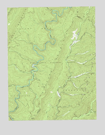
Wildell, WV USGS Topographic Map
Click on map above to begin viewing in our Map Viewer.

This topographic map contains these locations and features:
Feature Name Type Latitude Longitude GNIS ID View Map
Clubhouse RunStreamN38.6323°W79.7603°1550734View Map
Cove RunStreamN38.6284°W79.8062°1550804View Map
Crouch Hunter Access TrailTrailN38.6948°W79.8634°1553576View Map
Crouch Ridge TrailTrailN38.6859°W79.8534°1550848View Map
Crouch RunStreamN38.6787°W79.8420°1550849View Map
Elklick RunStreamN38.6701°W79.7878°1551044View Map
Enviro Energy MineMineN38.6832°W79.8415°1553620View Map
Fox RunStreamN38.6904°W79.7914°1551172View Map
Gaudineer Scenic AreaParkN38.6268°W79.8451°1551210View Map
Gertrude (historical)Populated PlaceN38.6690°W79.7862°1727956View Map
Gertrude RunStreamN38.6696°W79.7876°1551224View Map
Glade RunStreamN38.6634°W79.8459°1551237View Map
Iron Bridge RunStreamN38.6393°W79.8059°1551545View Map
Johns Camp RunStreamN38.6754°W79.8381°1551589View Map
Johns Camp Run ShelterLocaleN38.6618°W79.8220°1551590View Map
MayPopulated PlaceN38.6534°W79.8023°1555070View Map
McGee RunStreamN38.7073°W79.8376°1552030View Map
Mikes RunStreamN38.6962°W79.7878°1552092View Map
Mill RunStreamN38.6534°W79.8031°1552123View Map
North South TrailTrailN38.6954°W79.8034°1552347View Map
Old Road RunStreamN38.6251°W79.8239°1552383View Map
Snorting Lick RunStreamN38.7123°W79.7784°1552954View Map
Span Oak RunStreamN38.6273°W79.7778°1552986View Map
Stalnaker RunStreamN38.7462°W79.8098°1553040View Map
Suter RunStreamN38.7326°W79.8212°1553147View Map
Turkey Hunter Access TrailTrailN38.6890°W79.8492°1553654View Map
Whitmeadow Hunter Access TrailTrailN38.6765°W79.8670°1553573View Map
Whitmeadow RunStreamN38.6629°W79.8631°1553439View Map
WildellPopulated PlaceN38.7112°W79.7806°1553454View Map
Wildell School (historical)SchoolN38.7134°W79.7773°1727986View Map
Wildell ShelterLocaleN38.7446°W79.7762°1553455View Map
Yokum Hunter Access TrailTrailN38.7065°W79.8526°1553653View Map
Yokum RunStreamN38.6896°W79.8323°1553539View Map

Note: Coordinates in the location and feature list above are referenced to NAD83 datum.


Copyright (C) 2008-2025 Ryan Niemi / Sunset Dynamics ... All Rights Reserved